
Smoke Forecast for Friday, July 18, 2025 9:30 AM
Current Conditions
Friday will be the warmest day of the next several days and it will allow fuels to continue to cure. Surface smoke will pour into Montana because of numerous active fires burning around the region. Considering the time of year and the ongoing drought, it is remarkable that there aren’t any large, active wildfires burning in Montana.
The Big Bear and Rush fires burning in the Bitterroot Range of central Idaho, just southwest of the Bitterroot Valley, exhibited active fire behavior again on Thursday. By late afternoon on Thursday, smoke was pouring into southwest Montana. The Big Bear fire has grown to 3,539 acres and the Rush fire is up to 1,269 acres. The Cram fire burning near Madras, Oregon is now the largest fire n the country. It has burned through 91,861 acres. The Hope fire burning in northeast Washington, just south of the Canadian border, grew quickly on Thursday because of breezy and warm weather. It has grown to 7,414 acres.
At 9:00 AM Friday, Great Falls, Libby, and Sleeping Giant's air quality is Moderate.
By Saturday evening, the HRRR smoke model shows some surface smoke over southwest Montana from wildfires burning in Idaho.
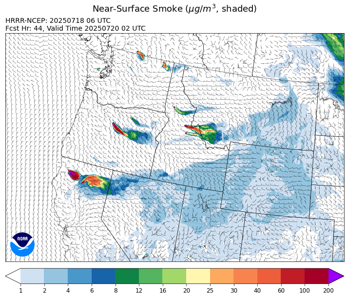
Source: HRRR-smoke
Forecast
Friday will be the warmest day of the week as highs will soar well into the upper 80s and low 90s. The combination of warm temperatures, dry fuels, and gusty afternoon winds will allow the Big Bear and Rush fires burning in central Idaho to expand once more. A westerly flow will push smoke into Ravalli and Beaverhead Counties at times. An isolated thunderstorm is possible by Friday afternoon, particularly across southwest Montana.
Saturday will be cooler but will remain dry and breezy. Gusty winds and low relative humidity will produce critical fire weather and should allow existing blazes to expand further. A weak system will be enough to kick off an isolated thunderstorm or two along the US-2 corridor Saturday afternoon between Glacier National Park and the Hi-Line.
Forecast models continue to agree on another cool, wet storm arriving in Montana by early next week. It will be similar to the storm that preceded it earlier this week. The bulk of the heaviest precipitation will focus over northwest Montana. The storm will trigger scattered showers and thunderstorms late Monday and into Tuesday. The cooler airmass and precipitation should help to moderate fire behavior on existing wildfires and reduce surface smoke concentrations. Stay tuned!
Conditions can change quickly as weather could stimulate active fires and the likelihood of new starts increases. Please keep track of concentrations at todaysair.mtdeq.us or the Fire and Smoke Map.
Friday morning’s satellite shows some light smoke over southwest Montana because of wildfires burning in the central Idaho mountains.
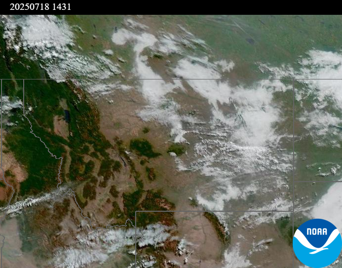
Source: NOAA
| Incident Name | State | Location | Acres | Containment |
|---|---|---|---|---|
| Rush - IDPAF | Idaho | Frank Church-River of No Return Wilderness | 1269 | NA |
| Big Bear - IDPAF | Idaho | Frank Church-River of No Return Wilderness | 3539 | NA |
| Cherry Fire - IDPDS | Idaho | Approximately 1 mile northeast of Deary | 113 | 0% |
| Shingle - IDNCF | Idaho | NA | 100 | NA |
| Post Fire - IDNCF | Idaho | North of US Highway 12, East of Mocus Point Trailhead | 144 | 94% |
| Green Mountain Fire & Garnet Fire - MTMTS | Montana | NA | 70 | 30% |
| Cram Fire - ORPRD | Oregon | 15 miles north of Madras, OR | 91861 | 0% |
| Elk Fire - OR98S | Oregon | 7 miles SW of Beatty, Oregon | 2640 | 61% |
| Hagelstein Fire - OR98S | Oregon | 14 miles north of Klamath Falls, Oregon | 666 | 7% |
| Western Pines - WANES | Washington | 10 miles northeast of Davenport | 5781 | 95% |
| Hope Fire - WANES | Washington | Approximately 15 Miles north of Kettle Falls, WA and 5 miles southwest of Northport, WA | 7414 | 25% |
| Pomas Fire 2025 - WAOWF | Washington | Approximately 36 miles northwest of Entiat, WA | 3521 | NA |
| Bear Gulch Fire - WAOLF | Washington | The fire is burning on a steep, rocky slope near the Mt. Rose Trailhead along the Lake Cushman Corridor (FS-24). | 562 | 19% |
| Greenacres - WANES | Washington | 5 miles north of Omak | 921 | 95% |
| Siegel Fire - WANES | Washington | 14 Miles south of Cheney, WA | 700 | 93% |
Tags: Smoke Forecast 2025