
Smoke Forecast for Thursday, July 18, 2024 10:00 AM
Current Conditions
The Miller Peak fire saw a decrease in fire activity on Wednesday, as high pressure provided less wind. The fire has burned an estimated 1,971 acres. The Horse Gulch blaze showed some growth on Wednesday, but light winds are limiting smoke impacts to areas immediately adjacent to the fire. Because of several active fires in Southeast Montana, the town of Broadus continues to see periods of degraded air quality.
See the latest Air Resource Advisor report from the Horse Gulch fire here
See the latest Air Resource Advisor report from the Miller Peak fire here
At 9:00 AM Thursday, Thompson Falls, Columbia Falls, Seeley Lake, Helena, Sleeping Giant, Frenchtown, Missoula, Great Falls, Butte, West Yellowstone, Bozeman, Billings, and Broadus were enduring Moderate air quality.
Thursday morning’s satellite reveals smoke pouring into Western Montana from fires burning in and out of the state.
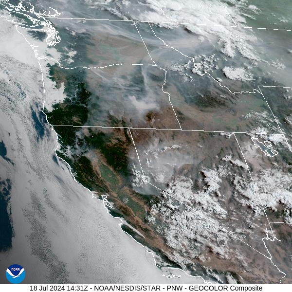
Source: NOAA
Forecast
Mainly high elevation smoke will drift into Montana on Thursday due to numerous wildfires burning upstream in Washington, Idaho, and Oregon. Isolated thunderstorms are possible in the mountains. Any storms that do pop up will be capable of gusty winds and even some hail. Any wildfire adjacent to these storms will experience erratic fire behavior due to strong winds. Some monsoonal moisture has arrived in the Northern Rockies, so any of these storms will be capable of very heavy rain. West of the divide, less moisture is available, and the threat of dry thunderstorms is a possibility. These storms will be capable of igniting new wildfires, due to very dry fuels and unseasonably warm temperatures.
Record warmth is possible by this weekend, depending on how dense the column of smoke is. Thunderstorm chances don’t go away but look to become even more isolated. Light easterly winds are forecasted to develop over the region Saturday night through Monday morning. If this verifies, it has the potential to bring smoke impacts from the Miller Peak fire into parts of the Bitterroot Valley. Depending on fire activity, easterly winds on the Horse Gulch fire would bring localized smoke impacts into parts of the Helena Valley.
By Friday afternoon, the HRRR smoke model shows the greatest smoke impacts over Southwest Montana because of the Miller Peak fire, and numerous fires burning in Idaho and Oregon.
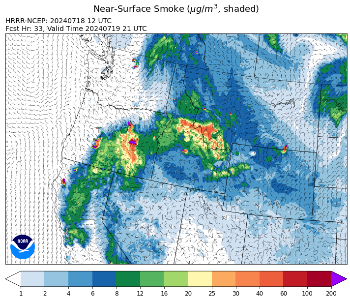
Source: HRRR Smoke
Conditions can change quickly as weather could stimulate active fires and the likelihood of new starts increases. Please keep track of concentrations at todaysair.mtdeq.us or the Fire and Smoke Map.
Current Wildfires
|
Incident |
State |
location |
acres |
containment |
|
Bench Lake Fire - IDSTF |
Idaho |
8 miles south of Stanley, Idaho |
1,850 |
3% |
|
Texas Fire - IDIDS |
Idaho |
Approximately three miles northeast of Kendrick, ID and 12 miles southwest of Deary, ID |
1,352 |
0% |
|
Billy Creek Fire - IDIDS |
Idaho |
14.71 Miles SSE of Asotin, WA |
3,185 |
74% |
|
Deadman Fire - MTMTS |
Montana |
Approx 17 mi south of Birney and north of the Tongue River Reservoir in Rosebud and Big Horn Counties |
39,161 |
0% |
|
Horse Gulch Fire - MTHLF |
Montana |
5 miles south of York |
14,250 |
32% |
|
Miller Peak Fire - MTLNF |
Montana |
8 miles southeast of Missoula |
1,971 |
NA |
|
Falls Fire - ORMAF |
Oregon |
20 miles NW of Burns |
110,674 |
5% |
|
Cow Valley Fire - ORVAD |
Oregon |
9 miles east of Ironside, Ore. |
133,408 |
77% |
|
Larch Creek Fire - OR95S |
Oregon |
Friend, OR, a rural community |
18,690 |
43% |
|
Lone Rock Fire - ORPRD |
Oregon |
Lonerock Oregon stretching West of HWY 207 |
77,020 |
10% |
|
Salt Creek - OR710S |
Oregon |
5 miles SSW of Butte Falls, Oregon |
4,102 |
84% |
|
Pioneer - WASES |
Washington |
10 miles southeast of Stehekin, WA |
25,688 |
14% |
|
Cougar Creek Fire - WAUMF |
Washington |
1 mile west of Hwy 129 and Grand Ronde river intersection |
3,091 |
0% |
Source: Inciweb
Tags: Smoke Forecast 2024