
Smoke Forecast for Thursday, July 17, 2025 9:30 AM
Current Conditions
Fuels are drying out once again across the Treasure State as warmer and drier weather returns. There is some light smoke over the state thanks to numerous regional wildfires.
The Big Bear fire burning in the Bitterroot Range of central Idaho, just southwest of the Bitterroot Valley, exhibited active fire behavior again on Wednesday. By late afternoon on Wednesday, smoke was pouring into Ravalli and Beaverhead Counties. The Big Bear fire has grown to 2,529 acres. The Cram fire burning near Madras, Oregon expanded on Wednesday and is now up to about 64,294 acres. The Hope fire burning in northwest Washington, just south of the Canadian border, grew quickly on Wednesday because of breezy and warm weather. It has grown to 7,414 acres.
At 9:00 AM Thursday, Libby, Columbia Falls, Sleeping Giant, and Sidney’s air quality is Moderate.
By early afternoon Friday, the HRRR smoke model shows some surface smoke over southwest Montana from wildfires burning in Idaho.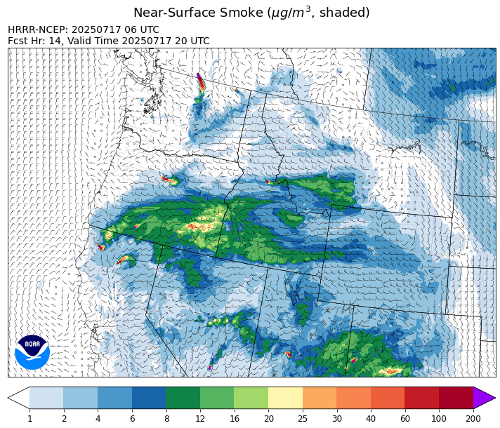
Source: HRRR-smoke
Forecast
A southwesterly flow will produce warm, dry, and breezy weather across Montana and the Pacific Northwest between Thursday and the weekend. This will allow existing wildfires to expand, producing additional surface smoke, particularly over communities adjacent to wildfires. The Big Bear fire in central Idaho remains active, and it will likely send additional smoke into southwest Montana in the coming days.
Friday will be even warmer with highs climbing well in the 90s in many western Montana valleys. There’s a slight chance for an afternoon thunderstorm, particularly across southwest Montana. A weak front will move across the region Friday night. It will be moisture starved, and the biggest impact to fire weather will be from strong westerly winds which will complicate afternoon firefighting operations.
On Monday, an unusually strong area of low pressure will move into the state. It is a similar setup to the storm that moved across the state earlier in the week. It will drag down unseasonably cool air from Canada. The system will bring wet conditions, particularly to northwest portions of the state. Stay tuned!
Conditions can change quickly as weather could stimulate active fires and the likelihood of new starts increases. Please keep track of concentrations at todaysair.mtdeq.us or the Fire and Smoke Map.
Thursday morning’s satellite shows some light smoke over northwest Montana because of wildfires burning in Washington and British Columbia.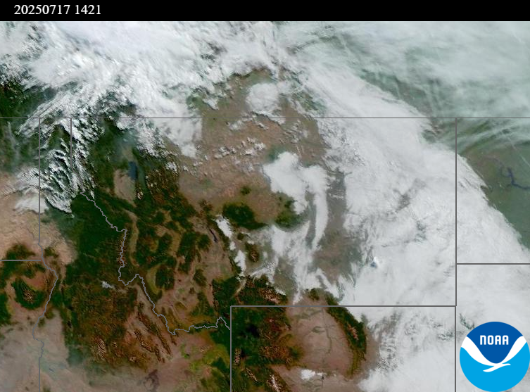
Source: NOAA
| Incident Name | State | Location | Acres | Containment |
|---|---|---|---|---|
| Rush - IDPAF | Idaho | Frank Church-River of No Return Wilderness | 747 | NA |
| Big Bear - IDPAF | Idaho | Frank Church-River of No Return Wilderness | 2529 | NA |
| Cherry Fire - IDPDS | Idaho | Approximately 1 mile northeast of Deary | 77 | 0% |
| Shingle - IDNCF | Idaho | NA | 100 | NA |
| Post Fire - IDNCF | Idaho | North of US Highway 12, East of Mocus Point Trailhead | 144 | 94% |
| Green Mountain Fire & Garnet Fire - MTMTS | Montana | NA | 69 | 10% |
| Cram Fire - ORPRD | Oregon | 15 miles north of Madras, OR | 64294 | 0% |
| Elk Fire - OR98S | Oregon | 7 miles SW of Beatty, Oregon | 2699 | 44% |
| Hagelstein Fire - OR98S | Oregon | 14 miles north of Klamath Falls, Oregon | 523 | 0% |
| Pomas Fire 2025 - WAOWF | Washington | Approximately 36 miles northwest of Entiat, WA | 3519 | NA |
| Hope Fire - WANES | Washington | Approximately 15 Miles north of Kettle Falls, WA and 5 miles southwest of Northport, WA | 7414 | 20% |
| Bear Gulch Fire - WAOLF | Washington | The fire is burning on a steep, rocky slope near the Mt. Rose Trailhead along the Lake Cushman Corridor (FS-24). | 498 | 19% |
| Greenacres - WANES | Washington | 5 miles north of Omak | 921 | 95% |
| Western Pines - WANES | Washington | 10 miles northeast of Davenport | 5781 | 60% |
| Siegel Fire - WANES | Washington | 14 Miles south of Cheney, WA | 700 | 93% |
Tags: Smoke Forecast 2025