
Smoke Forecast for Wednesday, July 16, 2025 9:20 AM
Current Conditions
The rain that fell across Montana moderated fire behavior some on the Garnet and Green Mountain fires burning near Ovando. The storm missed much of the Pacific Northwest, and numerous active fires continue to burn across Washington, Oregon, British Columbia, and Idaho.
The Big Bear fire burning in the Bitterroot Range of central Idaho, just southwest of the Bitterroot Valley, exhibited active fire behavior again on Tuesday. It has grown to 2,525 acres. The Cram fire burning near Madras, Oregon ballooned in size again on Tuesday and is now up to about 41,377 acres. It displayed extreme fire behavior on Tuesday. The Pomas fire burning in the Cascades of Washington was active again on Tuesday. It has burned 3,448 acres thus far. Lastly, the Young Creek fire burning in southern British Columbia exhibited active fire behavior again on Tuesday. Smoke could be seen on satellite pouring south into Washington on Tuesday afternoon.
At 9:00 AM Wednesday, Columbia Falls, Seeley Lake, Missoula, Cut Bank, Choteau, Great Falls, Lewistown, Malta, and Sidney's air quality is Moderate.
By midday Thursday the HRRR smoke model shows some surface smoke over western Montana from wildfires burning in Idaho.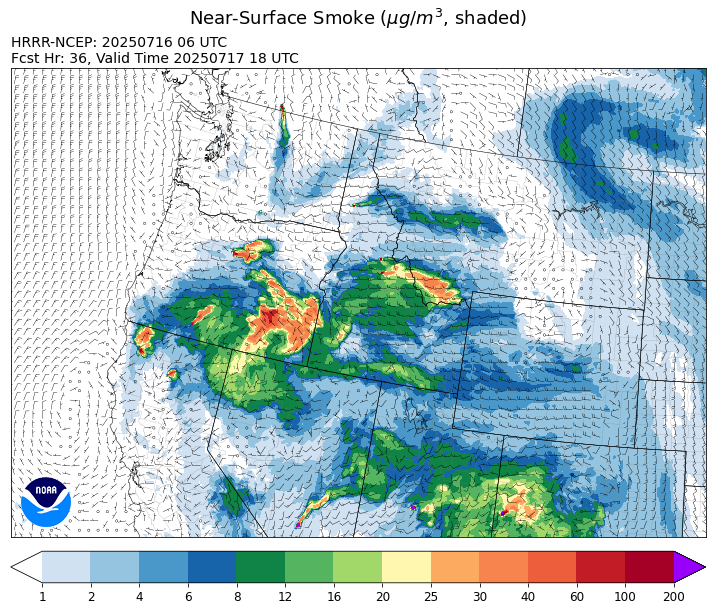
Source: HRRR-smoke
Forecast
The area of low pressure that produced the rainy and unseasonably cool day across the state on Tuesday gradually departs the state on Wednesday. The flow will gradually shift to the west on Wednesday, and this pattern will send smoke from the wildfires burning across Idaho into western portions of the Treasure State. As the flow shifts, the smoke from Canadian wildfires will exit the state, remaining mostly north of the border.
Temperatures should gradually moderate Thursday and Friday as afternoon relative humidity decreases. This drier atmosphere combined with gusty afternoon winds will lead to additional fire growth on the wildfires burning across Idaho and Montana. Smoke models continue to show a westerly flow sending plumes of smoke into western parts of Montana from Idaho wildfires. A fast-moving storm will bring clouds and chances for rain between Glacier National Park and the Hi-Line on Thursday, but much of the state will remain dry.
By Tuesday and Wednesday, forecast models are hinting at another cool and wet system moving across the state. It has the potential to bring some much-needed precipitation to the area and temporarily ease fire weather concerns. Stay tuned!
Conditions can change quickly as weather could stimulate active fires and the likelihood of new starts increases. Please keep track of concentrations at todaysair.mtdeq.us or the Fire and Smoke Map.
Wednesday morning’s satellite shows an area of low pressure departing the Treasure State while smoke from Canadian wildfires remains visible over northern portions of the state.
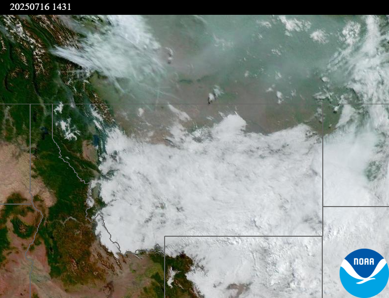
Source: NOAA
Tags: Smoke Forecast 2025