
Smoke Forecast for Tuesday, July 16, 2024 9:30 AM
Current Conditions
Despite breezy and hot conditions, the Horse Gulch fire showed little growth on Monday. Lighter winds on Tuesday will allow the smoke to pool and drain into surrounding areas from York to Canyon Ferry Lake. The Miller Peak Incident, just south of Missoula, experienced explosive growth on Monday, sending smoke east into places like Helena and the I-90 corridor.
See the latest Air Resource Advisor report from the Horse Gulch fire here
At 8:00 AM Tuesday, Thompson Falls, Frenchtown, Missoula, Great Falls, Butte, Dillon, West Yellowstone, Bozeman, Billings, and Broadus were enduring Moderate air quality.
Smoke continues to pour into Montana from fires burning in and out of the state.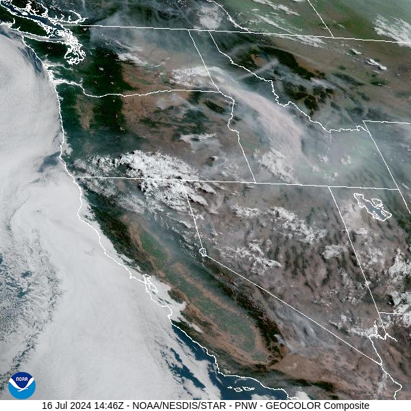
Source: NOAA
Forecast
Light winds are expected on Tuesday which will limit fire growth. However, light easterly winds could send smoke from the Miller Peak fire into parts of the Bitterroot and Missoula Valleys starting Tuesday night. Air quality could become degraded in places like Hamilton, Frenchtown, and Missoula through Wednesday night as light easterly winds persist.
High pressure will continue to provide hot, dry, and breezy conditions across the state. It will continue to dry out fuels across the region and allow for existing fires to gradually expand. Unfortunately, there is very little rain anticipated for the Northern Rockies over the next week so air quality will gradually deteriorate in places.
By late Tuesday night, the HRRR-Smoke model shows a large plume of heavy smoke coming off of the Miller Peak Incident, mixing with smoke from other regional wildfires.
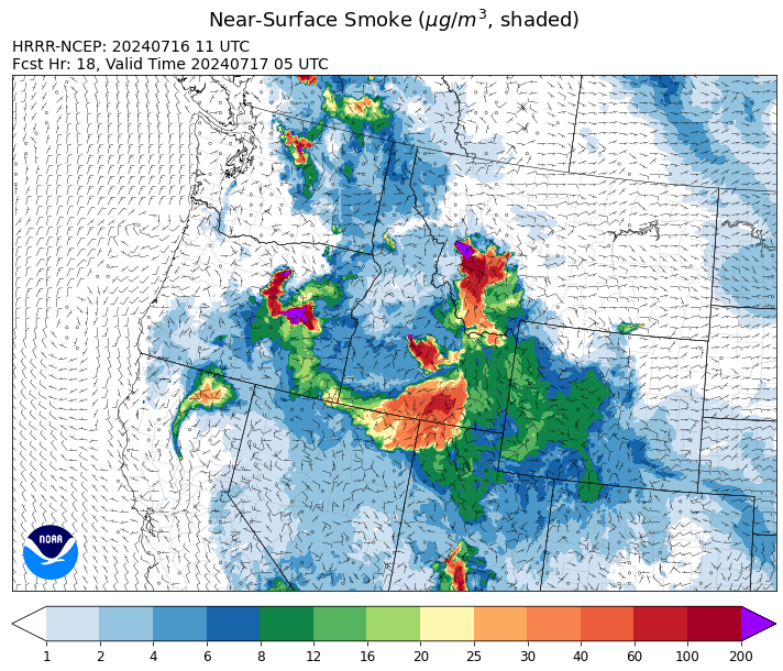
Source: HRRR Smoke
Conditions can change quickly as weather could stimulate active fires and the likelihood of new starts increases. Please keep track of concentrations at todaysair.mtdeq.us or the Fire and Smoke Map.
Current Wildfires
|
Incident |
State |
location |
acres |
containment |
|
Bench Lake Fire - IDSTF |
Idaho |
8 miles south of Stanley, Idaho |
1,275 |
0% |
|
Billy Creek Fire - IDIDS |
Idaho |
14.71 Miles SSE of Asotin, WA |
3,185 |
74% |
|
Deadman Fire - MTMTS |
Montana |
Approx 17 mi south of Birney and north of the Tongue River Reservoir in Rosebud and Big Horn Counties |
22,208 |
0% |
|
Horse Gulch Fire - MTHLF |
Montana |
5 miles south of York |
12,917 |
10% |
|
Miller Peak Fire - MTLNF |
Montana |
8 miles southeast of Missoula |
800 |
NA |
|
Running Wolf Fire - MTHLF |
Montana |
SW of Stanford, MT |
93 |
100% |
|
Falls Fire - ORMAF |
Oregon |
20 miles NW of Burns |
64,225 |
0% |
|
Cow Valley Fire - ORVAD |
Oregon |
9 miles east of Ironside, Ore. |
133,408 |
16% |
|
Salt Creek - OR710S |
Oregon |
5 miles SSW of Butte Falls, Oregon |
4,102 |
58% |
|
Little Yamsay Fire - ORFWF |
Oregon |
NA |
6,340 |
100% |
|
2023 Chilcoot Fire UNF - ORUPF |
Oregon |
Umpqua National Forest - 19 mi ENE of Glide, OR |
1,940 |
96% |
|
2023 Chilcoot Fire UNF - ORUPF |
Oregon |
Umpqua National Forest - 19 mi ENE of Glide, OR |
1,940 |
96% |
|
2023 Ridge Fire UNF - ORUPF |
Oregon |
Umpqua National Forest - 34mi East of Glide, OR and 36mi west of Chemult, OR |
214 |
100% |
|
2023 Ridge Fire UNF - ORUPF |
Oregon |
Umpqua National Forest - 34mi East of Glide, OR and 36mi west of Chemult, OR |
214 |
100% |
|
Pioneer - WASES |
Washington |
10 miles southeast of Stehekin, WA |
18,731 |
14% |
|
Gold Creek - WANES |
Washington |
3.25 miles south of Carlton, WA |
278 |
100% |
Source: Inciweb
Tags: Smoke Forecast 2024