
Smoke Forecast for Tuesday, July 15, 2025 9:30 AM
Current Conditions
Monday’s cold front has brought Canadian wildfire smoke back into northern portions of the state. Regional wildfires expanded over the last 24-hours and continue to transport smoke into Montana.
The Big Bear fire burning in the Bitterroot Range of central Idaho, just southwest of the Bitterroot Valley, exhibited active fire behavior again on Monday. It has grown to 2,052 acres. On Monday, smoke was impacting portions of Ravalli and Beaverhead Counties because of this blaze. A northerly flow should keep most of the impacts over Idaho on Tuesday. The Cram fire burning near Madras, Oregon ballooned in size on Monday and is now up to about 20,000 acres. It displayed extreme fire behavior on Monday. Behind Monday’s cold front, numerous active wildfires burning across Saskatchewan are sending smoke into northern parts of Montana. This smoke has led to deteriorating air quality at some monitors.
At 9:00 AM Tuesday, Havre’s air is Unhealthy. Choteau, Cut Bank, and Malta’s air is Unhealthy for Sensitive Groups. Great Falls and Sidney’s air quality is Moderate.
By Wednesday afternoon, the HRRR smoke model shows decreasing surface smoke concentrations across the state as winds shift from the north to the east.
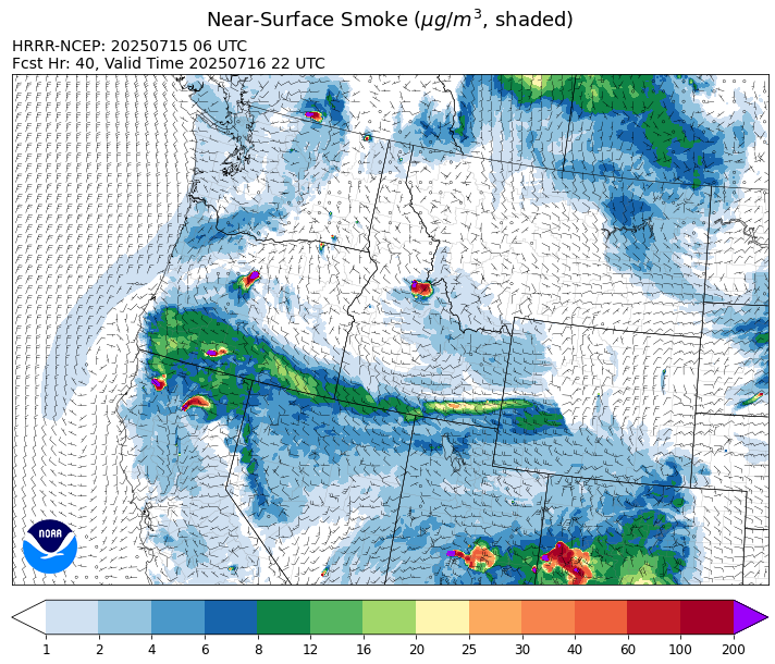
Source: HRRR-smoke
Forecast
Behind Monday’s cold front, Canadian wildfire smoke has sagged south of the border into northern sections of Montana. Strong northeasterly winds will continue to funnel this smoke into Montana. However, as the smoke gets further away from its source in central Saskatchewan, air quality values should gradually improve. Most smoke models show better air quality across the state by Tuesday evening.
An unusually potent area of low pressure will march across the state on Tuesday. It is producing some healthy rainfall totals, particularly north of I-90. Unfortunately, little to no rain will fall on the Garnet fire burning about 30 miles east of Missoula. Temperatures on Tuesday will be about 20-30 degrees cooler than they were on Monday. The cooler air should help moderate fire behavior on regional blazes.
The storm departs on Wednesday as more seasonable temperatures return to the Treasure State. By Thursday, a quick hitting system will race across the northern part of the state. It will provide some light precipitation between Glacier National Park and the Hi-Line, however much of the region will remain dry. A zonal flow will be the theme on Friday and into the weekend, allowing for a gradual moderating trend. The warmer temperatures and mainly dry weather should lead to more active fire behavior. Stay tuned!
Conditions can change quickly as weather could stimulate active fires and the likelihood of new starts increases. Please keep track of concentrations at todaysair.mtdeq.us or the Fire and Smoke Map.
Tuesday morning’s satellite shows widespread cloud cover across Montana because of a potent area of low pressure. This storm will provide some beneficial rain, particularly north of I-90.
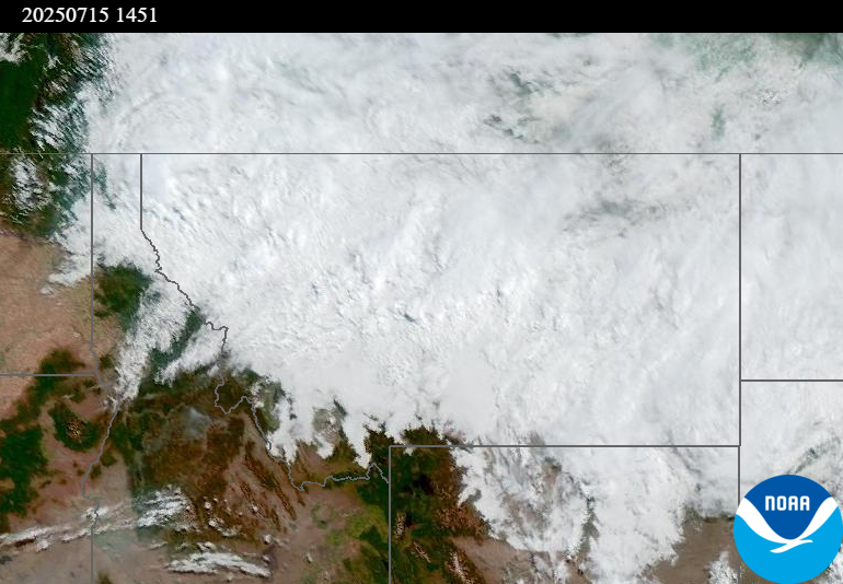
Source: NOAA
Tags: Smoke Forecast 2025