
Smoke Forecast for Monday, July 14, 2025 9:30 AM
Current Conditions
Numerous active regional wildfires burning across Idaho, Washington, and British Columbia continue to transport smoke into parts of Montana. One more warm day will likely generate active fire behavior on these blazes.
Over the weekend, fires in southern British Columbia exhibited extreme fire behavior. The Young Creek fire grew dramatically on Sunday thanks to unseasonably warm air and gusty winds. The smoke plume could be seen on satellite pushing into northwest Montana. The Young and Hope fires in Washington remained active over the weekend as well. Lastly, the Big Bear fire burning in Idaho, just southwest of the Bitterroot Valley, showed active fire behavior again on Sunday. However, a northerly flow kept most of the smoke away from the Treasure State. The only active wildfire burning in western Montana is the Garnet fire. It continues to burn east of Missoula, between I-90 and HWY 200.
At 9:00 AM Monday, Libby, Columbia Falls, and Sleeping Giant's air quality is Moderate.
By Tuesday afternoon, the HRRR smoke model shows a northerly flow sending Canadian wildfire smoke into northern portions of the state.
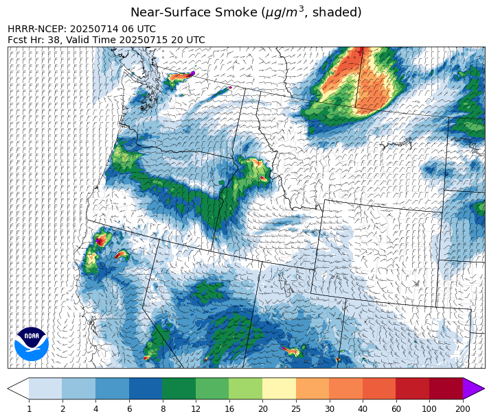
Source: HRRR-smoke
Forecast
The Garnet fire, burning east of Missoula will likely experience additional growth on Monday, due to gusty winds, dry fuels, and unseasonably warm air. An unusually strong cold front will move into northwest Montana by Monday afternoon. The front will generate northeasterly wind gusts up to 40 miles per hour. The front will kick off a few afternoon/evening thunderstorms, particularly across northwest Montana.
An area of low pressure will follow the front. It will produce some much-needed rain for the area, particularly north of I-90. Portions of northwest Montana could receive between one and two inches of rain between Monday and Wednesday. The precipitation and much cooler air should temporarily ease fire weather concerns and limit smoke production on the Garnet fire. The rain will gradually end from northwest to southeast on Wednesday. The northerly flow will push surface smoke from Canadian wildfires into the state on Wednesday, particularly north of I-90. Expect deteriorating air quality as a result.
A weak system will move into the Treasure State on Thursday. It should generate a few showers and thunderstorms. Behind this system, a ridge builds over the state. It should bring more seasonable temperatures to the area and allow fuels to dry out once more. Stay tuned!
Conditions can change quickly as weather could stimulate active fires and the likelihood of new starts increases. Please keep track of concentrations at todaysair.mtdeq.us or the Fire and Smoke Map.
Monday morning’s satellite shows some smoke over northwest Montana. A strong cold front in southern Canada is responsible for the clouds just north of the border.
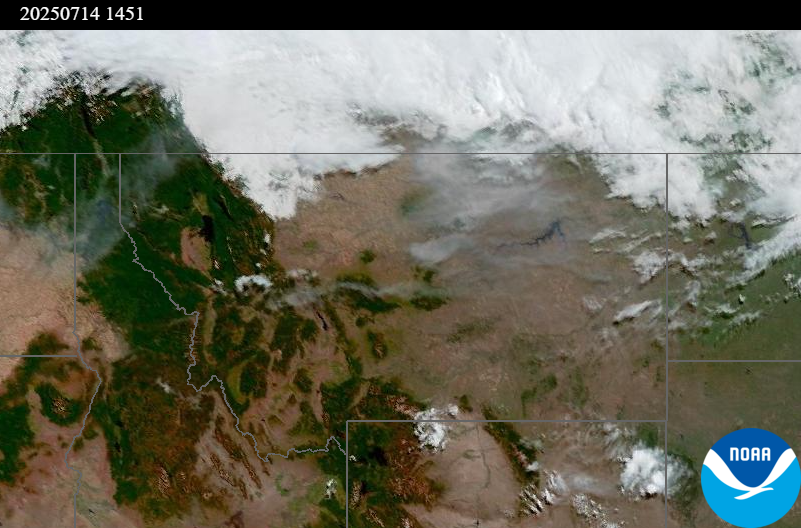
Source: NOAA
Tags: Smoke Forecast 2025