
Smoke Forecast for Friday, July 11, 2025 9:30 AM
Current Conditions
Numerous fires burning over western Canada and the Pacific Northwest are transporting smoke into the Treasure State.
There are several active fires burning over Washington state. On Thursday, the most active of these was the Hope fire burning near Marble, Washington, just south of the Canadian border. It has already burned through 5,634 acres. The Big Bear fire is burning in the Bitterroot Range, about 25 miles west of the Montana border. It exhibited active fire behavior on Thursday. This fire will send smoke into parts of southwest Montana in the coming days. There are also numerous active wildfires burning in Oregon and northern California. These regional wildfires combined with the unusually warm temperatures will contribute to increasing surface smoke over the region.
At 9:00 AM Friday, Sidney and Great Falls’ air quality is Moderate.
By Saturday afternoon, the HRRR smoke model shows some surface smoke moving into southwest Montana and the northeast corner of the state from regional wildfires.
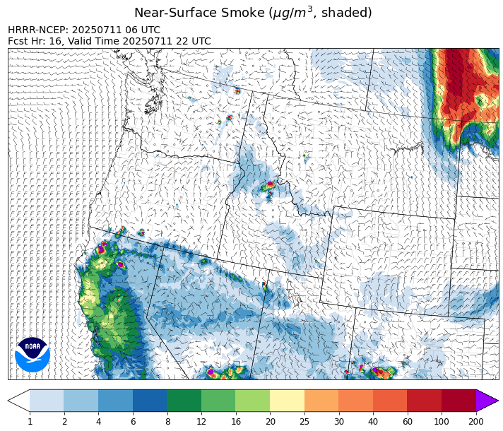
Source: HRRR-smoke
Forecast
A ridge of high pressure will build across the Northern Rockies and the Pacific Northwest Friday and into the weekend. The combination of warming temperatures, drying fuels, and gusty afternoon winds will allow for additional fire growth on regional wildfires. Forecast models continue to highlight the possibility of surface smoke from Canadian wildfires clipping far northeast Montana this weekend.
The Big Bear fire burning just west of the Montana border in the Bitterroot Mountains of Idaho expanded quickly on Thursday. High pressure over the weekend should allow this fire to continue to grow. However, northerly transport winds should keep the bulk of the smoke out of Montana.
Forecast models continue to advertise the potential for a significant storm moving out of British Columbia to impact Montana on Monday and Tuesday. The storm will bring significantly cooler air to the area along with gusty northeasterly winds. Models are showing the potential for widespread precipitation across Montana from this storm. If this were to verify, it would moderate fire behavior around the region and reduce surface smoke. We need the rain, and if this storm were to miss the area, we could go at least another week to ten days before the next round of precipitation. Think rain.
Conditions can change quickly as weather could stimulate active fires and the likelihood of new starts increases. Please keep track of concentrations at todaysair.mtdeq.us or the Fire and Smoke Map.
Friday morning’s satellite reveals some smoke over northern Montana from Canadian wildfires, while a cold front pushes clouds through southeast Montana.
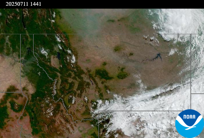
Source: NOAA
Tags: Smoke Forecast 2025