
Smoke Forecast for Wednesday, July 9, 2025 9:30 AM
Current Conditions
Regional wildfires continue to send light surface smoke into portions of Montana early Wednesday. Unseasonably warm temperatures and gusty winds will create erratic fire behavior on existing blazes.
The Pomas Fire burning in the western Washington Cascades continue to exhibit extreme fire behavior. The Pomas Fire has burned 2,890 acres. The Hope fire near Marble, Washington, just south of the Canadian border expanded quickly on Tuesday, exhibiting active fire behavior. It has already burned through 3,000 acres. There are also numerous active wildfires burning in Oregon and northern California. These regional wildfires combined with the unusually warm temperatures will contribute to an uptick in surface smoke around Montana on Wednesday.
At 9:00 AM Wednesday, Great Falls’ air quality is Moderate.
The HRRR smoke model shows some surface smoke moving into Western Montana by midday Thursday from numerous regional wildfires.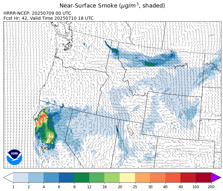
Source: HRRR-smoke
Forecast
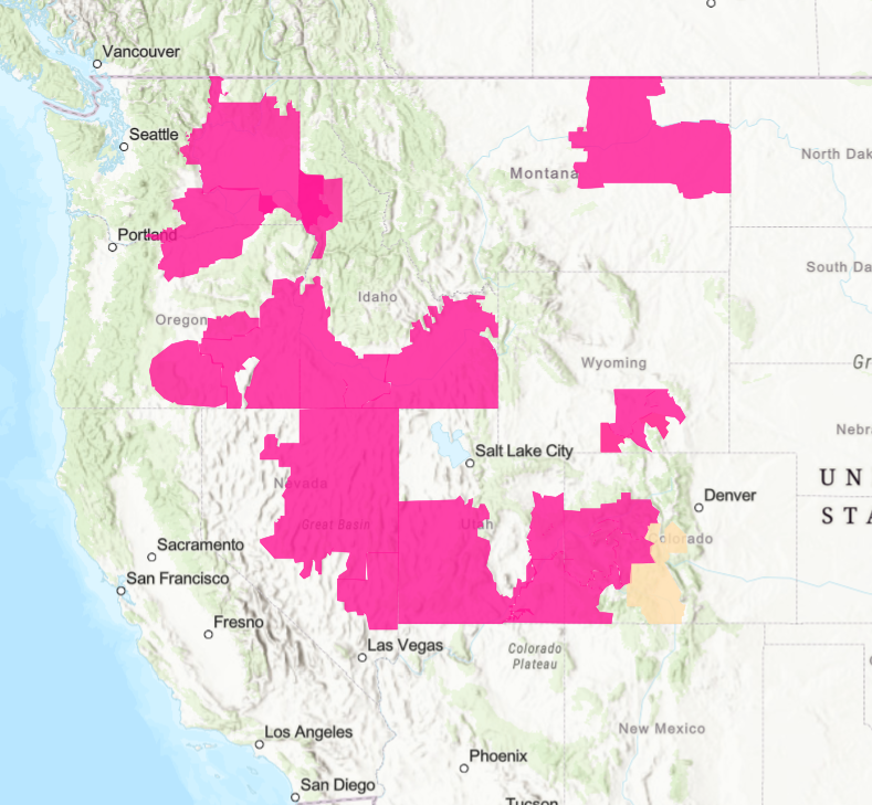
Red flag warnings are in effect for several western states including northeast Montana on Wednesday due to dry fuels, low humidity, gusty winds, and the threat for dry thunderstorms. Numerous wildfires across Oregon, Washington, and northern California have experienced tremendous growth over the last 48-hours. Many of these fires will be active again on Wednesday and they will transport light surface smoke into Montana.
There will be a few scattered storms around the Treasure State on Wednesday. However, the system moving across the Northern Rockies late Wednesday and Thursday has much less rain than was previously modeled.
A trough drops south into Montana on Thursday. It will provide cooler temperatures and some beneficial rainfall, particularly across northwest Montana. The cooler air and higher humidity should ease fire weather concerns. Warmer and drier conditions return for the weekend as high pressure builds over the Northern Rockies. Stay tuned!
Conditions can change quickly as weather could stimulate active fires and the likelihood of new starts increases. Please keep track of concentrations at todaysair.mtdeq.us or the Fire and Smoke Map.
Red flag warnings (in red) are in effect for several western state on Wednesday because of low humidity, dry fuels, and gusty winds.
Source: NOAA
Tags: Smoke Forecast 2025