
Smoke Forecast for Tuesday, October 15, 2024
Current Conditions
One more day of dry and unseasonably warm weather before big changes arrive. Wildfire smoke will continue to impact the region, particularly Southwest Montana.
There are numerous active wildfires still burning in the Central Idaho mountains. This combined with a couple of wildfires in Montana will keep smoke and haze around the Treasure State again on Tuesday. In Central Idaho southwest of Salmon, the Black Eagle and Red Rock fires have merged and remain very active. These wildfires have combined to burn over 82,000 acres. The Daly fire burning east of Hamilton in the Sapphire Mountains has grown over 9.500 acres. This fire is 56% contained and it is the largest staffed wildfire in Montana, with 227 people working on it.
See the latest Air Resource Advisor report from Central Idaho and Southwest Montana here
At 9:00 AM Tuesday, Libby, Missoula, Hamilton, Butte, Dillon, Bozeman, Helena, Sleeping Giant, Great Falls, Lewistown, and Billings were enduring Moderate air quality.
Tuesday morning’s satellite shows widespread smoke lingering over the Northern Rockies because of numerous regional wildfires.
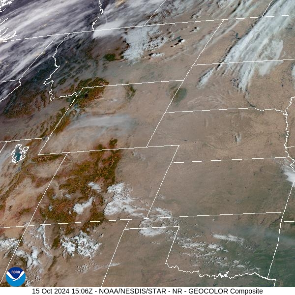
Source: NOAA
Forecast
One more day of ridging can be expected on Tuesday before significant weather changes arrive late Wednesday. The ridge will result in another day of active fire behavior, with surface smoke plaguing parts of Western Montana. The greatest impacts to air quality will likely be felt over portions of Ravalli and Beaverhead Counties.
A cold front will push east of the Montana/Idaho border around sunrise Wednesday. It will be accompanied by breezy surface winds. These winds should help to scour out much of the surface smoke in the valleys of Southwest Montana, allowing air quality to improve. The mountains of Central Idaho where numerous active wildfires continue to burn are expected to receive at least a half an inch of precipitation from this system. The mountains of Southwest Montana should pick up at least a quarter of an inch of rain. The precipitation should help to moderate fire behavior and gradually reduce smoke around the region.
By Thursday morning, snow levels will drop to 3,500 feet. The passes will receive some snowfall from this storm, with 1-2 inches possible before the storm exits early Friday. A ridge builds over the Northern Rockies by this weekend. It will provide slightly warmer temperatures for the Treasure State. The combination of a decreasing fall sun angle and slightly cooler air should keep fire behavior and smoke production in check. Stay tuned!
By midday Wednesday, the HRRR smoke model shows decreasing surface smoke as a cold front marches across the state.
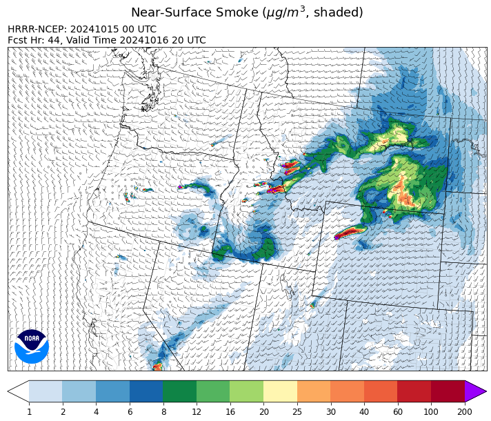
Source: HRRR Smoke
Conditions can change quickly as weather could stimulate active fires and the likelihood of new starts increases. Please keep track of concentrations at todaysair.mtdeq.us or the Fire and Smoke Map.
Current Wildfires
|
Incident |
State |
location |
acres |
containment |
|
Lava Fire - IDBOF |
Idaho |
12 miles SW of Cascade, ID |
97,585 |
90% |
|
Logan Fire - IDPAF |
Idaho |
The fire is centered around Edwardsburg, but has burned north, east, west and south of the community. It has moved into the Wilderness area. Krassel Ranger District, Payette National Forest |
15,131 |
10% |
|
Wapiti Fire - IDBOF |
Idaho |
10 miles west of Stanley, ID |
128,357 |
85% |
|
Middle Fork Complex Fire: Bulldog and Nellie - IDBOF |
Idaho |
7 miles east of Garden Valley, ID |
61,495 |
90% |
|
Snag Fire - IDBOF |
Idaho |
9.5 miles east of Cascade, Idaho |
33,437 |
90% |
|
Goat Fire - IDBOF |
Idaho |
8 miles SE of Cascade, Idaho |
35,648 |
51% |
|
2024 Valley Fire - IDIDS |
Idaho |
Boise Foothills near Warm Springs Avenue and Hwy 21 |
9,904 |
79% |
|
Parks Fire - IDPAF |
Idaho |
NA |
5,978 |
NA |
|
Farrow Fire - IDPAF |
Idaho |
NA |
3,084 |
NA |
|
Elkhorn Fire - IDPAF |
Idaho |
Krassel Ranger District, Payette National Forest |
26,048 |
NA |
|
South Selway Complex - IDNCF |
Idaho |
Selway-Bitterroot Wilderness |
1,927 |
NA |
|
Boulder Creek Fire - IDNCF |
Idaho |
Within Game Unit 12: located ten miles north of the Powell Ranger Station and 12 miles west of Lolo Hot Springs |
40 |
NA |
|
Grave Butte Fire - IDNCF |
Idaho |
Within Game Unit 12: located ten miles west of Jerry Johnson Campground and about half a mile from National Forest Service Road #107 (Saddle Camp Road) |
23 |
NA |
|
Surprise Fire - IDNCF |
Idaho |
Three and one-half miles NE of Hunter Peak, Fifteen miles NW of Darby, MT in the Selway-Bitterroot Wilderness |
792 |
NA |
|
Cracker Jack Complex - IDNCF |
Idaho |
Whistling Pig Canyon East of Jumbo Camp |
5,240 |
NA |
|
Dollar Fire - IDBOF |
Idaho |
18 miles NE of Cascade, Idaho |
4,360 |
8% |
|
Chimney Fire - IDEIX |
Idaho |
9 miles northwest of Fairfield, ID |
6,521 |
80% |
|
Copper Fire - IDPAF |
Idaho |
NA |
2,129 |
NA |
|
Burnt Creek Fire - IDPAF |
Idaho |
NA |
2,665 |
NA |
|
Slab Fire - IDPAF |
Idaho |
NA |
50 |
50% |
|
Moore Square Complex - IDNCF |
Idaho |
Both Fires are located in the Gospel-Hump Wilderness Area near Square Mountain |
3,673 |
50% |
|
Moose Creek Complex - IDNCF |
Idaho |
East Moose creek Bridge to Elbow Bend impacted |
14,762 |
NA |
|
Bulltrout Fire - IDBOF |
Idaho |
15 miles WNW OF Stanley, ID |
271 |
92% |
|
Robbin Fire - IDNCF |
Idaho |
Within Game Unit 12: located less than six and a half miles southwest of Powell Ranger Station and less than three and a half miles south of Wendover Campground |
NA |
NA |
|
Bench Lake Fire - IDSTF |
Idaho |
8 miles south of Stanley, Idaho |
2,595 |
90% |
|
Oxbow Fire - IDPAF |
Idaho |
Near Oxbow dam in Hells Canyon |
6,000 |
NA |
|
Garden Fire - IDSCF |
Idaho |
Approximately two (2) miles southwest of the confluence of Panther Creek and the Main Salmon River on the North Fork Ranger District in the Frank Church River of No Return Wilderness |
10,302 |
0% |
|
Red Rock Fire - IDSCF |
Idaho |
15 miles west of Salmon, ID |
74,131 |
19% |
|
Birch Fire - IDSCF |
Idaho |
The west side of the Middle Fork of the Salmon River on Norton Ridge on the Middle Fork Ranger District in the Frank Church River of No Return Wilderness |
22,545 |
0% |
|
Nugget Fire - IDSCF |
Idaho |
Approximately 40 miles west of Salmon on the North Fork Ranger District in the Frank Church River of No Return Wilderness, west of the Middle Fork of the Salmon River |
994 |
0% |
|
Vanity Fire - IDSCF |
Idaho |
37 NW West of Challis, Idaho |
600 |
30% |
|
Meridian - MTBDF |
Montana |
40 miles south of Ennis, MT |
1,425 |
NA |
|
Sheep Creek - MTBDF |
Montana |
5 miles southwest of Bernice, MT |
574 |
NA |
|
Railroad-Daly Fire - MTBRF |
Montana |
Railroad Creek/ Skalkaho Creek confluence, 26 miles SE of Hamilton |
12,383 |
NA |
|
Johnson Fire - MTBRF |
Montana |
3 miles south of Springer Memorial Community in the East Fork of the Bitterroot |
6,687 |
NA |
|
Grouse - MTBDF |
Montana |
Ten miles southwest of Wise River, MT |
6,100 |
NA |
|
Ratio Mountain - MTBDF |
Montana |
15 miles northwest of Whitehall, MT. |
2,091 |
NA |
|
Sharrott Creek Fire - MTBRF |
Montana |
Three miles west of Stevensville, Montana |
3,204 |
NA |
|
Long Tom Fire - MTMTS |
Montana |
10 miles south of Anaconda, MT |
57 |
57% |
|
Magruder Ridge Fire - MTBRF |
Montana |
Selway Bitterroot Wilderness |
3,625 |
0% |
|
Elkhorn Ridge - MTBRF |
Montana |
West Fork District |
3,125 |
0% |
|
Trail Ridge Fire - MTBDF |
Montana |
22 miles NW of Wisdom MT |
18,138 |
80% |
|
McDermott - MTBDF |
Montana |
17 miles northwest of Philipsburg, MT |
427 |
NA |
|
Marsh Creek - MTHLF |
Montana |
12 Miles Southeast of Lincoln, MT |
151 |
0% |
|
Remington Fire - MTGNF |
Montana |
14 miles NE of Leiter, WY, multiple counties in southeast Montana. |
196,368 |
88% |
|
Pentagon Fire - MTFNF |
Montana |
45 miles SE of Bigfork, MT |
62 |
0% |
|
Rail Ridge - OROCF |
Oregon |
Less than 1 mile south of Dayville, OR |
175,060 |
89% |
|
Willamette Complex Fires - South - ORWIF |
Oregon |
Willamette Complex South fires are 8 miles north and 8 to 22 miles S-SE of Oakridge. |
31,296 |
NA |
|
Tiger Creek Fire - ORUMF |
Oregon |
15 southeast of Walla Walla, WA. |
534 |
73% |
|
Bachelor Complex Fires - ORDEF |
Oregon |
Mt Bachelor, 20 miles SW Bend, OR |
15,342 |
63% |
|
Red Fire - ORDEF |
Oregon |
Diamond Peak Wilderness, 16 miles west, north-west of Crescent Oregon. |
3,033 |
15% |
|
Bingham Fire - ORWIF |
Oregon |
Bingham Ridge: 2 miles east of Marion Forks and 10 miles south east of Idanha |
199 |
94% |
|
Homestead Complex - ORUPF |
Oregon |
Thirty miles northeast of Glide Oregon |
11,073 |
35% |
|
Diamond Complex - ORUPF |
Oregon |
18 miles southwest of Chemult, Oregon |
11,141 |
90% |
|
Lane 1 Fire - OR77S |
Oregon |
Approximately 16 miles SE of Springfield, OR |
25,952 |
99% |
|
North Willamette Complex - ORWIF |
Oregon |
Willamette National Forest |
5,492 |
NA |
|
Whisky Creek Fire - ORMHF |
Oregon |
East fork of Herman Creek, 6 miles SE of Cascade Locks, OR |
3,203 |
25% |
|
Microwave Tower Fire - OR95S |
Oregon |
1 mile WSW of Mosier, OR |
1,313 |
95% |
|
Wiley Flat - OROCF |
Oregon |
10 miles southeast of Post, Oregon |
30,186 |
98% |
|
Buck Creek Fire - ORFWF |
Oregon |
12 miles southwest of Silver Lake in a semi-primitive area of the Forest with limited road access. |
5,758 |
98% |
|
Middle Fork Fire - ORCLP |
Oregon |
Crater Lake National Park; Middle Fork area |
5,286 |
70% |
|
Shoe Fly Fire - OR95S |
Oregon |
6 Miles NE of Mitchell, Oregon |
26,817 |
89% |
|
Copperfield Fire - OR98S |
Oregon |
10 miles east of Chiloquin, Oregon |
3,822 |
94% |
|
Lone Rock Fire - ORPRD |
Oregon |
Lonerock stretching to west of HWY 207 and south to HWY 19 |
137,222 |
98% |
|
Battle Mountain Complex - OR97S |
Oregon |
West and south of Ukiah, OR |
183,026 |
94% |
|
Warner Peak Fire - ORSHR |
Oregon |
3 miles East of Plush, on the Hart Mountain Antelope Refuge |
65,866 |
85% |
|
Town Gulch - ORWWF |
Oregon |
Eagle Creek Rd Area, 24 Miles East of Baker City OR, 8 Miles N of Richland, OR |
18,220 |
89% |
|
Cliff Mountain - ORWWF |
Oregon |
25 Miles East of Joseph, Oregon |
1,108 |
75% |
|
Porcupine Fire - ORBUD |
Oregon |
Porcupine Reservoir |
6,491 |
95% |
|
Badland Complex 2024 - ORVAD |
Oregon |
Baker County, Oregon |
54,563 |
99% |
|
Durkee Fire - ORVAD |
Oregon |
1 mile west of Durkee, Oregon |
294,265 |
95% |
|
Cow Valley Fire - ORVAD |
Oregon |
West of Brogan and Northwest of Vale |
133,490 |
99% |
|
Williams Mine Fire-GPNF - WAGPF |
Washington |
3.5 miles NNW of Trout Lake WA |
13,092 |
32% |
|
Ruby Fire - WANCP |
Washington |
On Ruby Mountain in North Cascade National Park by Diablo and Ross Lake, 9 miles East of Newhalem |
1,336 |
0% |
|
Pincer Two Fire - WAMSF |
Washington |
Johannesburg Mountain. 1 Mile East of Mineral Park Campground |
211 |
0% |
|
Easy Fire - WAOWF |
Washington |
North Cascades Hwy 20 Corridor, 17 air miles west of Mazama, WA |
2,130 |
36% |
|
Retreat - WASES |
Washington |
14 miles WSE of Naches, WA |
45,601 |
85% |
|
Lodgepole - WAOWF |
Washington |
16 miles west of Cliffdell, WA |
35 |
6% |
|
Cougar Creek Fire - WASES |
Washington |
1 mile west of Hwy 129 and Grand Ronde river intersection |
24,091 |
80% |
|
Kachess Complex - WAOWF |
Washington |
12 miles west of Cle Elum drainage |
23 |
NA |
|
Elk Fire 2024 - WYBHF |
Wyoming |
Bighorn National Forest |
90,475 |
26% |
|
House Draw Fire - WYHPD |
Wyoming |
9 Mile SE of Buffalo |
174,547 |
94% |
|
Clearwater - WYSHF |
Wyoming |
11 Miles West of Wapiti, Wyoming |
1,966 |
91% |
|
Pack Trail Fire - WYBTF |
Wyoming |
2 miles northeast of the confluence of the South Fork and North Fork of Fish Creek |
86,555 |
0% |
|
Leeds Creek - WYBTF |
Wyoming |
16 Miles Southwest of Dubois, WY |
780 |
75% |
Source: Inciweb
Tags: Smoke Forecast 2024