
Smoke Forecast for Monday, October 7, 2024 9:00 AM
Current Conditions
Montana DEQ has issued an Air Quality Alert until 8AM Tuesday for Ravalli, Granite, Silver Bow, Madison, Beaverhead, Lewis and Clark, Deer Lodge, Jefferson, and Powell Counties.
A stubborn ridge of high pressure will produce anomalously warm weather across the Northern Rockies this week. It will allow smoke from active wildfires burning in Idaho, Montana, and Wyoming to impact the Treasure State.
At 8:00 AM Monday, Libby, Columbia Falls, Great Falls, Frenchtown, Missoula, Sleeping Giant, Helena, Hamilton, Bozeman, Billings, and Broadus were enduring Moderate air quality. Butte was experiencing air that is Unhealthy for Sensitive Groups.
Monday morning’s satellite shows widespread smoke across much of the southern half of the state from regional wildfires.
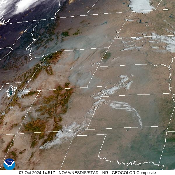
Source: NOAA
Forecast
Numerous active wildfires continue to burn over Montana, Idaho, and Wyoming. These fires will send smoke into Montana at times, particularly the southwest part of the state. Expect the usual diurnal fluctuations in surface smoke. As winds die down in the evening, expect the smoke to drain and pool into adjacent valleys. The worst air quality in this pattern is usually in the morning to around midday. Once the inversions break up around midday, better mixing will gradually push the surface smoke out of the valleys, leading to better air quality.
Afternoon highs will climb 10-15 degrees above average through Wednesday. The combination of warm air, dry fuels, and gusty afternoon winds will allow the fires in the region to remain active, despite a weakening fall sun angle.
Unfortunately, forecast models have backed off on precipitation amounts with a front by the end of the week and into the weekend. Thus, regional wildfires will continue to pump smoke into much of Montana for the foreseeable future. Stay tuned!
By late Tuesday, the HRRR smoke model shows high surface smoke concentrations over the state due to numerous active regional wildfires.
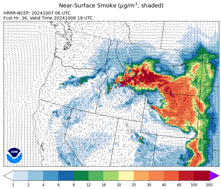
Source: HRRR Smoke
Conditions can change quickly as weather could stimulate active fires and the likelihood of new starts increases. Please keep track of concentrations at todaysair.mtdeq.us or the Fire and Smoke Map.
Current Wildfires
|
Incident |
State |
location |
acres |
containment |
|
Frog - IDSTF |
Idaho |
Little Boulder Creek off the East Fork of the Salmon River. (22 miles east/southeast of Stanley, Idaho) |
3,020 |
87% |
|
Lava Fire - IDBOF |
Idaho |
12 miles SW of Cascade, ID |
197,560 |
90% |
|
Wapiti Fire - IDBOF |
Idaho |
10 miles west of Stanley, ID |
126,817 |
80% |
|
Goat Fire - IDBOF |
Idaho |
8 miles SE of Cascade, Idaho |
31,345 |
27% |
|
Snag Fire - IDBOF |
Idaho |
9.5 miles east of Cascade, Idaho |
33,437 |
90% |
|
Middle Fork Complex Fire: Bulldog and Nellie - IDBOF |
Idaho |
7 miles east of Garden Valley, ID |
61,493 |
90% |
|
Elkhorn Fire - IDPAF |
Idaho |
Krassel Ranger District, Payette National Forest |
26,048 |
NA |
|
Logan Fire - IDPAF |
Idaho |
West of Edwardsburg, Krassel Ranger District, Payette National Forest |
9,747 |
NA |
|
South Selway Complex - IDNCF |
Idaho |
Selway-Bitterroot Wilderness |
1,927 |
NA |
|
Boulder Creek Fire - IDNCF |
Idaho |
Within Game Unit 12: located ten miles north of the Powell Ranger Station and 12 miles west of Lolo Hot Springs |
40 |
NA |
|
Grave Butte Fire - IDNCF |
Idaho |
Within Game Unit 12: located ten miles west of Jerry Johnson Campground and about half a mile from National Forest Service Road #107 (Saddle Camp Road) |
23 |
NA |
|
Surprise Fire - IDNCF |
Idaho |
Three and one-half miles NE of Hunter Peak, Fifteen miles NW of Darby, MT in the Selway-Bitterroot Wilderness |
792 |
NA |
|
Cracker Jack Complex - IDNCF |
Idaho |
Whistling Pig Canyon East of Jumbo Camp |
5,240 |
NA |
|
Parks Fire - IDPAF |
Idaho |
NA |
5,978 |
NA |
|
Dollar Fire - IDBOF |
Idaho |
18 miles NE of Cascade, Idaho |
4,360 |
8% |
|
Chimney Fire - IDEIX |
Idaho |
9 miles northwest of Fairfield, ID |
6,521 |
80% |
|
Copper Fire - IDPAF |
Idaho |
NA |
2,129 |
NA |
|
Burnt Creek Fire - IDPAF |
Idaho |
NA |
2,665 |
NA |
|
Farrow Fire - IDPAF |
Idaho |
NA |
1,783 |
NA |
|
Slab Fire - IDPAF |
Idaho |
NA |
50 |
50% |
|
Moore Square Complex - IDNCF |
Idaho |
Both Fires are located in the Gospel-Hump Wilderness Area near Square Mountain |
3,673 |
50% |
|
Moose Creek Complex - IDNCF |
Idaho |
East Moose creek Bridge to Elbow Bend impacted |
14,762 |
NA |
|
Bulltrout Fire - IDBOF |
Idaho |
15 miles WNW OF Stanley, ID |
271 |
92% |
|
Bench Lake Fire - IDSTF |
Idaho |
8 miles south of Stanley, Idaho |
2,595 |
90% |
|
Oxbow Fire - IDPAF |
Idaho |
Near Oxbow dam in Hells Canyon |
6,000 |
NA |
|
Garden Fire - IDSCF |
Idaho |
Approximately two (2) miles southwest of the confluence of Panther Creek and the Main Salmon River on the North Fork Ranger District in the Frank Church River of No Return Wilderness |
7,186 |
0% |
|
Vanity Fire - IDSCF |
Idaho |
37 NW West of Challis, Idaho |
600 |
30% |
|
Nugget Fire - IDSCF |
Idaho |
Approximately 40 miles west of Salmon on the North Fork Ranger District in the Frank Church River of No Return Wilderness, west of the Middle Fork of the Salmon River |
994 |
0% |
|
Mowitch Fire - IDSCF |
Idaho |
Approximately three (3) miles north of Indian Creek on the MIddle Fork Ranger District in the Frank Church River of No Return Wilderness. |
993 |
0% |
|
Birch Fire - IDSCF |
Idaho |
The west side of the Middle Fork of the Salmon River on Norton Ridge on the Middle Fork Ranger District in the Frank Church River of No Return Wilderness |
13,274 |
0% |
|
Black Eagle Fire - IDSCF |
Idaho |
21 miles west of Salmon |
50,000 |
15% |
|
Red Rock Fire - IDSCF |
Idaho |
15 miles west of Salmon, ID |
52,729 |
5% |
|
Grouse - MTBDF |
Montana |
Ten miles southwest of Wise River, MT |
6,009 |
NA |
|
Railroad-Daly Fire - MTBRF |
Montana |
Railroad Creek/ Skalkaho Creek confluence, 26 miles SE of Hamilton |
9,467 |
NA |
|
Sheep Creek - MTBDF |
Montana |
5 miles southwest of Bernice, MT |
400 |
NA |
|
Ratio Mountain - MTBDF |
Montana |
15 miles northwest of Whitehall, MT. |
2,091 |
NA |
|
Sharrott Creek Fire - MTBRF |
Montana |
Three miles west of Stevensville, Montana |
3,204 |
NA |
|
Long Tom Fire - MTMTS |
Montana |
10 miles south of Anaconda, MT |
57 |
57% |
|
Johnson Fire - MTBRF |
Montana |
3 miles south of Springer Memorial Community in the East Fork of the Bitterroot |
6,687 |
NA |
|
Magruder Ridge Fire - MTBRF |
Montana |
Selway Bitterroot Wilderness |
3,625 |
0% |
|
Elkhorn Ridge - MTBRF |
Montana |
West Fork District |
3,125 |
0% |
|
Trail Ridge Fire - MTBDF |
Montana |
22 miles NW of Wisdom MT |
18,138 |
80% |
|
McDermott - MTBDF |
Montana |
17 miles northwest of Philipsburg, MT |
427 |
NA |
|
Marsh Creek - MTHLF |
Montana |
12 Miles Southeast of Lincoln, MT |
151 |
0% |
|
Remington Fire - MTGNF |
Montana |
14 miles NE of Leiter, WY, multiple counties in southeast Montana. |
196,368 |
88% |
|
Pentagon Fire - MTFNF |
Montana |
45 miles SE of Bigfork, MT |
62 |
0% |
|
Rail Ridge - OROCF |
Oregon |
Less than 1 mile south of Dayville, OR |
169,074 |
89% |
|
Tiger Creek Fire - ORUMF |
Oregon |
15 southeast of Walla Walla, WA. |
398 |
5% |
|
Willamette Complex Fires - South - ORWIF |
Oregon |
Willamette Complex South fires are 8 miles north and 8 to 22 miles S-SE of Oakridge. |
24,792 |
NA |
|
Homestead Complex - ORUPF |
Oregon |
Thirty miles northeast of Glide Oregon |
10,552 |
35% |
|
Diamond Complex - ORUPF |
Oregon |
18 miles southwest of Chemult, Oregon |
11,141 |
90% |
|
Bingham Fire - ORWIF |
Oregon |
Bingham Ridge: 2 miles east of Marion Forks and 10 miles south east of Idanha |
183 |
0% |
|
Bachelor Complex Fires - ORDEF |
Oregon |
Mt Bachelor, 20 miles SW Bend, OR |
12,536 |
68% |
|
Red Fire - ORDEF |
Oregon |
Diamond Peak Wilderness, 16 miles west, north-west of Crescent Oregon. |
2,817 |
15% |
|
Lane 1 Fire - OR77S |
Oregon |
Approximately 16 miles SE of Springfield, OR |
25,952 |
99% |
|
North Willamette Complex - ORWIF |
Oregon |
Willamette National Forest |
5,394 |
NA |
|
Microwave Tower Fire - OR95S |
Oregon |
1 mile WSW of Mosier, OR |
1,313 |
95% |
|
Wiley Flat - OROCF |
Oregon |
10 miles southeast of Post, Oregon |
30,186 |
98% |
|
Sandstone Fire - ORMHF |
Oregon |
9 miles SW of Ripplebrook, OR, on the Mt. Hood National Forest |
702 |
85% |
|
Buck Creek Fire - ORFWF |
Oregon |
12 miles southwest of Silver Lake in a semi-primitive area of the Forest with limited road access. |
5,758 |
98% |
|
Whisky Creek Fire - ORMHF |
Oregon |
East fork of Herman Creek, 6 miles SE of Cascade Locks, OR |
3,203 |
25% |
|
Middle Fork Fire - ORCLP |
Oregon |
Crater Lake National Park; Middle Fork area |
5,286 |
70% |
|
Shoe Fly Fire - OR95S |
Oregon |
6 Miles NE of Mitchell, Oregon |
26,817 |
89% |
|
Copperfield Fire - OR98S |
Oregon |
10 miles east of Chiloquin, Oregon |
3,822 |
94% |
|
Lone Rock Fire - ORPRD |
Oregon |
Lonerock stretching to west of HWY 207 and south to HWY 19 |
137,222 |
98% |
|
Battle Mountain Complex - OR97S |
Oregon |
West and south of Ukiah, OR |
183,026 |
94% |
|
Warner Peak Fire - ORSHR |
Oregon |
3 miles East of Plush, on the Hart Mountain Antelope Refuge |
65,866 |
85% |
|
Town Gulch - ORWWF |
Oregon |
Eagle Creek Rd Area, 24 Miles East of Baker City OR, 8 Miles N of Richland, OR |
18,220 |
89% |
|
Cliff Mountain - ORWWF |
Oregon |
25 Miles East of Joseph, Oregon |
1,108 |
75% |
|
Porcupine Fire - ORBUD |
Oregon |
Porcupine Reservoir |
6,491 |
95% |
|
Badland Complex 2024 - ORVAD |
Oregon |
Baker County, Oregon |
54,563 |
99% |
|
Durkee Fire - ORVAD |
Oregon |
1 mile west of Durkee, Oregon |
294,265 |
95% |
|
Cow Valley Fire - ORVAD |
Oregon |
West of Brogan and Northwest of Vale |
133,490 |
99% |
|
Williams Mine Fire-GPNF - WAGPF |
Washington |
3.5 miles NNW of Trout Lake WA |
13,092 |
32% |
|
Ruby Fire - WANCP |
Washington |
On Ruby Mountain in North Cascade National Park by Diablo and Ross Lake, 9 miles East of Newhalem |
1,336 |
0% |
|
Pincer Two Fire - WAMSF |
Washington |
Johannesburg Mountain. 1 Mile East of Mineral Park Campground |
211 |
0% |
|
Pioneer - WASES |
Washington |
Approximate start 10 miles southeast of Stehekin, WA |
38,735 |
23% |
|
Easy Fire - WAOWF |
Washington |
North Cascades Hwy 20 Corridor, 17 air miles west of Mazama, WA |
2,130 |
36% |
|
Retreat - WASES |
Washington |
14 miles WSE of Naches, WA |
45,601 |
85% |
|
Lodgepole - WAOWF |
Washington |
16 miles west of Cliffdell, WA |
35 |
6% |
|
Cougar Creek Fire - WASES |
Washington |
1 mile west of Hwy 129 and Grand Ronde river intersection |
24,091 |
80% |
|
Kachess Complex - WAOWF |
Washington |
12 miles west of Cle Elum drainage |
23 |
NA |
|
Elk Fire 2024 - WYBHF |
Wyoming |
Bighorn National Forest |
72,998 |
0% |
|
House Draw Fire - WYHPD |
Wyoming |
9 Mile SE of Buffalo |
174,547 |
94% |
|
Clearwater - WYSHF |
Wyoming |
11 Miles West of Wapiti, Wyoming |
1,966 |
91% |
|
Pack Trail Fire - WYBTF |
Wyoming |
2 miles northeast of the confluence of the South Fork and North Fork of Fish Creek |
26,459 |
10% |
|
Fish Creek Fire - WYBTF |
Wyoming |
Twenty-two miles southeast of Moran, WY |
25,443 |
87% |
|
Leeds Creek - WYBTF |
Wyoming |
16 Miles Southwest of Dubois, WY |
780 |
75% |
Source: Inciweb
Tags: Smoke Forecast 2024