
Smoke Forecast for Thursday, September 12, 2024 9:30 AM
Current Conditions
A trough of low pressure continues to slide across the Treasure State. It will provide beneficial rain and mountain snow. The precipitation will moderate fire behavior and reduce smoke on regional wildfires.
Much of Idaho and Montana has already received a good soaking and more is on the way. The Wapiti fire is currently the largest wildfire in Idaho. It’s burning in the mountains of the Boise National Forest of Central Idaho. It has burned nearly 125,000 acres and is only 12% contained.
The Grouse fire burning just east of Wisdom has burned around 6,000 acres and is 22% contained. The Johnson fire burning just east of Sula has burned over 6,600 acres and is 25% contained. The Sharrott Creek fire just west of Stevensville is the largest staffed wildfire in the state, with 326 personnel assigned to it. has burned around 3,200 acres and is 35% contained. The Ratio Mountain fire burning east of Butte has burned more than 1,200 acres. It is 85% contained.
At 9:00 AM Thursday, Libby, Columbia Falls, Cut Bank, Great Falls, Lewistown, Malta, West Yellowstone, Miles City, Glendive, and Sidney were experiencing Moderate air quality.
Thursday morning’s satellite shows an area of low pressure marching across the Northern Rockies.
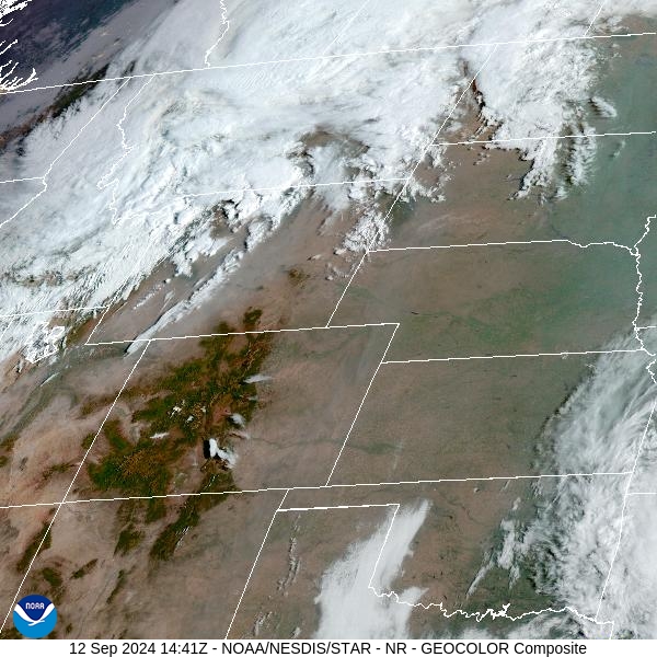
Source: NOAA
Forecast
What a difference a day makes! Beneficial rain arrived over the Northern Rockies late Wednesday. Much of the region has already received several tenths of precipitation and more is on the way. The mountains above 6,000 feet will continue to see periods of heavy snow, creating treacherous travel across the passes. Precipitation has helped to moderate fire behavior across the region and limit smoke production. The storm departs early Friday.
High pressure builds back over the Treasure State this weekend. It will allow temperatures to bounce back to near seasonal levels. Fire activity could briefly pick up as afternoon highs warm back into the 70s. Parts of Southwest Montana adjacent to the wildfires burning in Central Idaho could see some increases in surface smoke.
A trough is expected to be the big weather story for much of the following week. It will produce another round of widespread precipitation for much of the Treasure State along with seasonably cool temperatures. This pattern should do wonders for our air quality and will help to limit smoke production on regional wildfires.
By late Friday, the HRRR smoke model shows surface smoke concentrations picking up over Southwest Montana behind a departing trough.
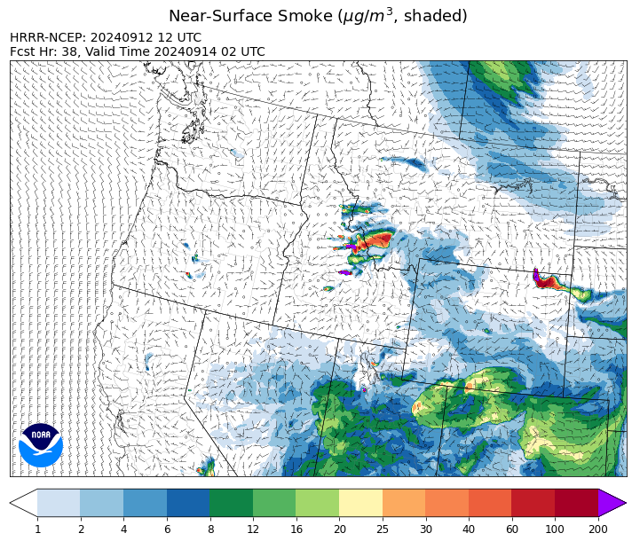
Source: HRRR Smoke
Conditions can change quickly as weather could stimulate active fires and the likelihood of new starts increases. Please keep track of concentrations at todaysair.mtdeq.us or the Fire and Smoke Map.
Current Wildfires
|
Incident |
State |
location |
acres |
containment |
|
Frog - IDSTF |
Idaho |
Little Boulder Creek off the East Fork of the Salmon River |
2,500 |
0% |
|
Wapiti Fire - IDBOF |
Idaho |
2 miles southwest of Grandjean, ID |
125,429 |
12% |
|
Goat Fire - IDBOF |
Idaho |
11 miles SE of Cascade, Idaho |
25,648 |
0% |
|
Dollar Fire - IDBOF |
Idaho |
18 miles NE of Cascade, Idaho |
4,338 |
8% |
|
Snag Fire - IDBOF |
Idaho |
9.5 miles East of Cascade, Idaho |
33,244 |
15% |
|
Chimney Fire - IDEIX |
Idaho |
9 miles northwest of Fairfield, ID |
6,475 |
10% |
|
Moore Square Complex - IDNCF |
Idaho |
Both Fires are located in the Gospel-Hump Wilderness Area near Square Mountain |
3,673 |
49% |
|
Limepoint Fire - IDPAF |
Idaho |
8 miles NE of Oxbow Dam |
33,084 |
95% |
|
Lava Fire - IDBOF |
Idaho |
12 miles SW of Cascade, ID |
93,781 |
6% |
|
Middle Fork Complex Fire: Bulldog and Nellie - IDBOF |
Idaho |
9 miles east of Garden Valley, ID |
61,159 |
30% |
|
Slab Fire - IDPAF |
Idaho |
NA |
25 |
NA |
|
Logan Fire - IDPAF |
Idaho |
West of Edwardsburg, Krassel Ranger District, Payette National Forest |
200 |
NA |
|
Moose Creek Complex - IDNCF |
Idaho |
East Moose creek Bridge to Elbow Bend impacted |
10,388 |
NA |
|
South Selway Complex - IDNCF |
Idaho |
Selway-Bitterroot Wilderness |
NA |
NA |
|
Surprise Fire - IDNCF |
Idaho |
Three and one-half miles NE of Hunter Peak, Fifteen miles NW of Darby, MT in the Selway-Bitterroot Wilderness |
763 |
NA |
|
Copper Fire - IDPAF |
Idaho |
NA |
315 |
NA |
|
Farrow Fire - IDPAF |
Idaho |
NA |
1,069 |
NA |
|
Burnt Creek Fire - IDPAF |
Idaho |
NA |
2,665 |
NA |
|
Parks Fire - IDPAF |
Idaho |
NA |
5,610 |
NA |
|
Cracker Jack Complex - IDNCF |
Idaho |
All four fires are located within half a mile of each other: two and a half miles east of Concord, ID, less than a quarter acre east from Square Lake and less than a quarter acre west from Fish Lake. |
3,800 |
NA |
|
Vanity - IDSCF |
Idaho |
37 NW West of Challis, Idaho |
559 |
20% |
|
Black Eagle Fire - IDSCF |
Idaho |
21 miles west of Salmon |
5,941 |
0% |
|
Red Rock Fire - IDSCF |
Idaho |
15 miles west of Salmon, ID |
2,570 |
0% |
|
Sharrott Creek Fire - MTBRF |
Montana |
Three miles west of Stevensville, Montana |
3,204 |
NA |
|
Ratio Mountain - MTBDF |
Montana |
15 miles northwest of Whitehall, MT. |
1,966 |
NA |
|
Marsh Creek - MTHLF |
Montana |
12 Miles Southeast of Lincoln, MT |
151 |
0% |
|
Magruder Ridge Fire - MTBRF |
Montana |
Selway Bitterroot Wilderness |
3,586 |
0% |
|
McDermott - MTBDF |
Montana |
17 miles northwest of Philipsburg, MT |
425 |
NA |
|
Elkhorn Ridge - MTBRF |
Montana |
West Fork District |
3,125 |
0% |
|
Grouse - MTBDF |
Montana |
Ten miles southwest of Wise River, MT |
6,009 |
22% |
|
Johnson Fire - MTBRF |
Montana |
3 miles south of Springer Memorial Community in the East Fork of the Bitterroot |
6,662 |
NA |
|
Railroad-Daly Fire - MTBRF |
Montana |
Railroad Creek/ Skalkaho Creek confluence, 26 miles SE of Hamilton |
6,721 |
NA |
|
Long Tom Fire - MTMTS |
Montana |
10 miles south of Anaconda, MT |
88 |
0% |
|
McElwain Fire - MTMTS |
Montana |
10 miles west of Helmville, MT |
116 |
75% |
|
Remington Fire - MTGNF |
Montana |
14 miles NE of Leiter, WY, multiple counties in southeast Montana. |
196,368 |
88% |
|
Flat Top and Firestone Fires - ORDEF |
Oregon |
North of Fort Rock, OR |
NA |
NA |
|
Bachelor Complex Fires - ORDEF |
Oregon |
Mt Bachelor, 20 miles SW Bend, OR |
5,987 |
NA |
|
Devils Knob and Milepost 98 Fires - ORUPF |
Oregon |
5 miles southeast of Tiller, OR |
4,130 |
13% |
|
North Willamette Complex - ORWIF |
Oregon |
Willamette National Forest |
4,631 |
NA |
|
Fossil Complex - OR95S |
Oregon |
1.5 miles NW of Spray;10 miles east of Fossil; 5 miles NE of Monument, Oregon |
22,441 |
3% |
|
Wiley Flat - OROCF |
Oregon |
10 miles southeast of post, Oregon |
29,904 |
48% |
|
Buck Creek Fire - ORFWF |
Oregon |
12 miles southwest of Silver Lake in a semi-primitive area of the Forest with limited road access. |
5,062 |
0% |
|
Milepost 98 - ORUPF |
Oregon |
The MIiepost 98 fire is located approximately 1 mile south of Canyonville. |
250 |
21% |
|
Middle Fork Fire - ORCLP |
Oregon |
Crater Lake National Park; Middle Fork area |
5,286 |
70% |
|
Shoe Fly Fire - OR95S |
Oregon |
6 Miles NE of Mitchell, Oregon |
26,774 |
53% |
|
Sandstone Fire - ORMHF |
Oregon |
9 miles SW of Ripplebrook, OR, on the Mt. Hood National Forest |
702 |
75% |
|
Whisky Creek Fire - ORMHF |
Oregon |
East fork of Herman Creek, 6 miles SE of Cascade Locks, OR |
3,047 |
25% |
|
Cottage Grove - Lane 1 - OR77S |
Oregon |
Approximately 16 miles SE of Springfield, OR |
25,927 |
99% |
|
Homestead Complex - ORUPF |
Oregon |
Thirty miles northeast of Glide Oregon |
9,483 |
33% |
|
Microwave Tower Fire - OR95S |
Oregon |
1 mile WSW of Mosier, OR |
1,313 |
95% |
|
Rail Ridge - OROCF |
Oregon |
Approx. 7 miles south of Dayville, OR |
161,675 |
12% |
|
Copperfield Fire - OR98S |
Oregon |
10 miles east of Chiloquin, Oregon |
3,822 |
94% |
|
Two Cabin - OR95S |
Oregon |
4 Miles NE of Monument Oregon |
251 |
5% |
|
Swauk Creek - WASES |
Washington |
Kittitas County, WA |
320 |
3% |
|
Ruby Fire - WANCP |
Washington |
On Ruby Mountain in North Cascade National Park by Diablo and Ross Lake, 9 miles East of Newhalem |
1,300 |
0% |
|
Williams Mine Fire-GPNF - WAGPF |
Washington |
3.5 miles NNW of Trout Lake WA |
13,089 |
31% |
|
Huckleberry Ridge Fire - WAPCS |
Washington |
20 miles south of Pe Ell, Washington |
293 |
8% |
|
Pincer Two Fire - WAMSF |
Washington |
Johannesburg Mountain. 1 Mile East of Mineral Park Campground |
211 |
0% |
|
Pioneer - WASES |
Washington |
Approximate start 10 miles southeast of Stehekin, WA |
38,735 |
23% |
Source: Inciweb
Tags: Smoke Forecast 2024