
Smoke Forecast for Wednesday, September 11, 2024 8:30 AM
Current Conditions
Montana DEQ has issued an Air Quality Alert until 9AM Thursday for Beaverhead, Deer Lodge, Granite, Ravalli, and Silver Bow Counties until 8AM Wednesday because of elevated particulate levels from wildfire smoke.
A trough of low pressure moves across that state late Wednesday. It will gradually help to scour the surface smoke over the region and provide some beneficial rain.
There are still several large, active fires burning in Central Idaho. The Wapiti fire is currently the largest wildfire in Idaho. It’s burning in the mountains of the Boise National Forest of Central Idaho. It has burned nearly 122,000 acres and is only 12% contained.
Several fires burning in Western Montana continue to grow. The Grouse fire burning just east of Wisdom has burned around 6,000 acres and is 22% contained. The Johnson fire burning just east of Sula has burned nearly 6,500 acres and is 25% contained. The Sharrott Creek fire just west of Stevensville is the largest staffed wildfire in the state, with 346 personnel assigned to it. has burned around 3,100 acres and is 36% contained. The Ratio Mountain fire burning east of Butte has burned more than 1,200 acres. It is 85% contained.
At 8:00 AM Wednesday, Libby, Thompson Falls, Columbia Falls, Frenchtown, Missoula, Seeley Lake, Helena, Great Falls, Lewistown, Bozeman, Billings, and Sidney were enduring Moderate air quality. Hamilton, Dillon, and Butte were experiencing air that is Unhealthy. Miles City, Glendive, and Broadus were enduring Unhealthy for Sensitive Groups air.
Wednesday morning’s satellite shows a trough of low pressure approaching providing increasing clouds for Montana.
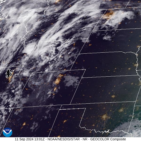
Source: NOAA
Forecast
Air quality will remain degraded over several counties in Southwest Montana again on Wednesday. However, a powerful area of low pressure will begin to scour out the surface smoke late in the day. Much of the region will receive more than half an inch of precipitation from this storm through early Friday. It will help to moderate fire behavior and limit smoke production. By Thursday, the entire region will be breathing cleaner air as a result.
The higher terrain over Western Montana has a good chance of picking up several inches of snow. Snow could fall as low as 6,000 feet from this system, and travel could become tricky over the passes. A ridge moves over the Treasure State this weekend, providing drier and warmer weather.
By Tuesday and Wednesday of next week, another trough of low pressure swings into Montana. Expect another round of beneficial rain and mountain snow. The timely precipitation should help to keep regional wildfires in check and help reduce surface smoke concentrations over the area. Stay tuned!
By late Thursday the HRRR smoke model shows surface smoke concentrations dropping over the Northern Rockies thanks to a trough of low pressure.
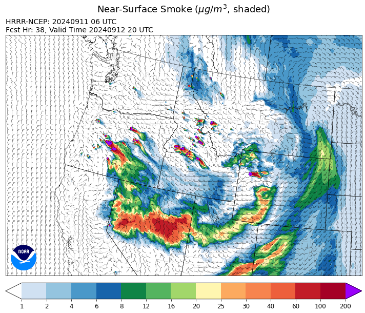
Source: HRRR Smoke
Conditions can change quickly as weather could stimulate active fires and the likelihood of new starts increases. Please keep track of concentrations at todaysair.mtdeq.us or the Fire and Smoke Map.
Current Wildfires
|
Incident |
State |
location |
acres |
containment |
|
Lava Fire - IDBOF |
Idaho |
12 miles SW of Cascade, ID |
69,658 |
0% |
|
Moore Square Complex - IDNCF |
Idaho |
Both Fires are located in the Gospel-Hump Wilderness Area near Square Mountain |
3,673 |
49% |
|
Frog - IDSTF |
Idaho |
Little Boulder Creek off the East Fork of the Salmon River |
1,800 |
0% |
|
Snag Fire - IDBOF |
Idaho |
9.5 miles East of Cascade, Idaho |
33,139 |
15% |
|
Goat Fire - IDBOF |
Idaho |
11 miles SE of Cascade, Idaho |
21,449 |
0% |
|
Dollar Fire - IDBOF |
Idaho |
18 miles NE of Cascade, Idaho |
4,338 |
8% |
|
Boulder Fire - IDBOF |
Idaho |
9 Miles Southwest of Cascade, Idaho. |
8,799 |
24% |
|
Wapiti Fire - IDBOF |
Idaho |
2 miles southwest of Grandjean, ID |
122,233 |
12% |
|
Middle Fork Complex Fire: Bulldog and Nellie - IDBOF |
Idaho |
9 miles east of Garden Valley, ID |
60,807 |
30% |
|
Chimney Fire - IDEIX |
Idaho |
9 miles northwest of Fairfield, ID |
6,146 |
10% |
|
Slab Fire - IDPAF |
Idaho |
NA |
25 |
NA |
|
Logan Fire - IDPAF |
Idaho |
West of Edwardsburg, Krassel Ranger District, Payette National Forest |
200 |
NA |
|
Limepoint Fire - IDPAF |
Idaho |
8 miles NE of Oxbow Dam |
33,075 |
95% |
|
Moose Creek Complex - IDNCF |
Idaho |
East Moose creek Bridge to Elbow Bend impacted |
10,388 |
NA |
|
South Selway Complex - IDNCF |
Idaho |
Selway-Bitterroot Wilderness |
NA |
NA |
|
Surprise Fire - IDNCF |
Idaho |
Three and one-half miles NE of Hunter Peak, Fifteen miles NW of Darby, MT in the Selway-Bitterroot Wilderness |
763 |
NA |
|
Copper Fire - IDPAF |
Idaho |
NA |
315 |
NA |
|
Farrow Fire - IDPAF |
Idaho |
NA |
1,069 |
NA |
|
Burnt Creek Fire - IDPAF |
Idaho |
NA |
2,665 |
NA |
|
Parks Fire - IDPAF |
Idaho |
NA |
5,610 |
NA |
|
Cracker Jack Complex - IDNCF |
Idaho |
All four fires are located within half a mile of each other: two and a half miles east of Concord, ID, less than a quarter acre east from Square Lake and less than a quarter acre west from Fish Lake. |
3,800 |
NA |
|
Red Rock Fire - IDSCF |
Idaho, United States |
15 miles west of Salmon, ID |
2,570 |
0% |
|
Black Eagle Fire - IDSCF |
Idaho, United States |
21 miles west of Salmon |
5,941 |
0% |
|
Vanity - IDSCF |
Idaho, United States |
37 NW West of Challis, Idaho |
559 |
20% |
|
Johnson Fire - MTBRF |
Montana |
3 miles south of Springer Memorial Community in the East Fork of the Bitterroot |
6,469 |
NA |
|
Sharrott Creek Fire - MTBRF |
Montana |
Three miles west of Stevensville, Montana |
3,193 |
NA |
|
Marsh Creek - MTHLF |
Montana |
12 Miles Southeast of Lincoln, MT |
130 |
0% |
|
Long Tom Fire - MTMTS |
Montana |
10 miles south of Anaconda, MT |
90 |
0% |
|
Grouse - MTBDF |
Montana |
Ten miles southwest of Wise River, MT |
6,000 |
22% |
|
Railroad-Daly Fire - MTBRF |
Montana |
Railroad Creek/ Skalkaho Creek confluence, 26 miles SE of Hamilton |
6,080 |
6% |
|
McDermott - MTBDF |
Montana |
17 miles northwest of Philipsburg, MT |
425 |
NA |
|
Elkhorn Ridge - MTBRF |
Montana |
West Fork District |
3,125 |
0% |
|
McElwain Fire - MTMTS |
Montana |
10 miles west of Helmville, MT |
116 |
75% |
|
Magruder Ridge Fire - MTBRF |
Montana |
Selway Bitterroot Wilderness |
1652 |
0% |
|
Remington Fire - MTGNF |
Montana |
14 miles NE of Leiter, WY, multiple counties in southeast Montana. |
196,368 |
88% |
|
Ratio Mountain - MTBDF |
Montana |
15 miles northwest of Whitehall, MT. |
1,226 |
NA |
|
Middle Fork Fire - ORCLP |
Oregon |
Crater Lake National Park; Middle Fork area |
5,286 |
70% |
|
Diamond Complex - ORUPF |
Oregon |
18 miles southwest of Chemult, Oregon |
11,141 |
86% |
|
North Willamette Complex - ORWIF |
Oregon |
Willamette National Forest |
4,631 |
NA |
|
Flat Top and Firestone Fires - ORDEF |
Oregon |
North of Fort Rock, OR |
NA |
NA |
|
Bachelor Complex Fires - ORDEF |
Oregon |
Mt Bachelor, 20 miles SW Bend, OR |
5,987 |
NA |
|
Rail Ridge - OROCF |
Oregon |
Approx. 7 miles south of Dayville, OR |
157,759 |
12% |
|
Devils Knob and Milepost 98 Fires - ORUPF |
Oregon |
5 miles southeast of Tiller, OR |
4,058 |
0% |
|
Red Fire - ORDEF |
Oregon |
Diamond Peak Wilderness, 16 miles west, north-west of Crescent Oregon. |
1,696 |
0% |
|
Willamette Complex Fires - South - ORWIF |
Oregon |
Willamette Complex South fires are 8 miles north and 8 to 22 miles S-SE of Oakridge. |
22,943 |
NA |
|
Shoe Fly Fire - OR95S |
Oregon |
6 Miles NE of Mitchell, Oregon |
26,502 |
41% |
|
Milepost 98 - ORUPF |
Oregon |
The MIiepost 98 fire is located approximately 1 mile south of Canyonville. |
240 |
0% |
|
Wiley Flat - OROCF |
Oregon |
10 miles southeast of post, Oregon |
28,396 |
41% |
|
Sandstone Fire - ORMHF |
Oregon |
9 miles SW of Ripplebrook, OR, on the Mt. Hood National Forest |
702 |
75% |
|
Whisky Creek Fire - ORMHF |
Oregon |
East fork of Herman Creek, 6 miles SE of Cascade Locks, OR |
2,977 |
25% |
|
Cottage Grove - Lane 1 - OR77S |
Oregon |
Approximately 16 miles SE of Springfield, OR |
25,927 |
99% |
|
Buck Creek Fire - ORFWF |
Oregon |
12 miles southwest of Silver Lake in a semi-primitive area of the Forest with limited road access. |
3,501 |
0% |
|
Homestead Complex - ORUPF |
Oregon |
Thirty miles northeast of Glide Oregon |
18,973 |
33% |
|
Fossil Complex - OR95S |
Oregon |
1.5 miles NW of Spray;10 miles east of Fossil; 5 miles NE of Monument, Oregon |
15,552 |
3% |
|
Copperfield Fire - OR98S |
Oregon |
10 miles east of Chiloquin, Oregon |
3,822 |
86% |
|
Two Cabin - OR95S |
Oregon |
4 Miles NE of Monument Oregon |
251 |
5% |
|
Swauk Creek - WASES |
Washington |
Kittitas County, WA |
214 |
3% |
|
Ruby Fire - WANCP |
Washington |
On Ruby Mountain in North Cascade National Park by Diablo and Ross Lake, 9 miles East of Newhalem |
1,300 |
0% |
|
Williams Mine Fire-GPNF - WAGPF |
Washington |
3.5 miles NNW of Trout Lake WA |
13,089 |
31% |
|
Huckleberry Ridge Fire - WAPCS |
Washington |
20 miles south of Pe Ell, Washington |
293 |
0% |
|
Pincer Two Fire - WAMSF |
Washington |
Johannesburg Mountain. 1 Mile East of Mineral Park Campground |
211 |
0% |
|
Pioneer - WASES |
Washington |
Approximate start 10 miles southeast of Stehekin, WA |
38,735 |
23% |
Source: HRRR Smoke
Tags: Smoke Forecast 2024