
Smoke Forecast for Tuesday, September 10, 2024 9:30 AM
Current Conditions
Montana DEQ has issued an Air Quality Alert until 8AM Wednesday for Beaverhead, Deer Lodge, Granite, Madison, Ravalli, and Silver Bow Counties until 8AM Wednesday because of elevated particulate levels from wildfire smoke.
Surface smoke remains a concern across much of the state. Gusty afternoon winds will help to scour out smoke from some of the valleys, while pushing smoke further away from regional wildfires.
There are still several large, active fires burning in Central Idaho. The Wapiti fire is currently the largest wildfire in Idaho. It’s burning in the mountains of the Boise National Forest of Central Idaho. It has burned nearly 120,000 acres and is only 12% contained.
Several fires burning in Western Montana continue to grow. The Grouse fire burning just east of Wisdom has burned around 5,700 acres and is 22% contained. The Johnson fire burning just east of Sula has burned nearly 6,300 acres and is 25% contained. The Sharrott Creek fire just west of Stevensville is the largest staffed wildfire in the state, with 354 personnel assigned to it. has burned around 3,000 acres and is 36% contained. The Ratio Mountain fire burning east of Butte has burned more than 1,200 acres. It is 54% contained.
At 9:00 AM Tuesday, Libby, Columbia Falls, Frenchtown, Missoula, Helena, Lewistown, West Yellowstone, Sidney, Broadus, and Lewistown were enduring Moderate air quality. Hamilton, Butte, Bozeman, Billings, Miles City, and Glendive were experiencing air that is Unhealthy. Dillon was enduring Very Unhealthy air.
Tuesday morning’s satellite shows widespread heavy smoke across much of Montana, Idaho, and Oregon.
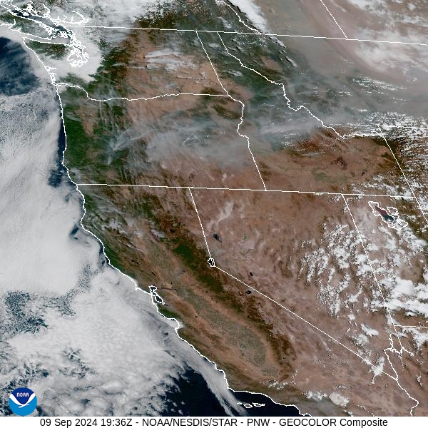
Source: NOAA
Forecast
An approaching trough will be enough to kick up wind across the Northern Rockies by Tuesday afternoon. Gusts over 30 miles per hour will help to scour out surface smoke in many of the valleys. Southwest Montana will continue to experience poor air quality at times due to westerly transport winds and their proximity to numerous wildfires. A widely isolated shower or storm is possible Tuesday afternoon, but the smoke will tend to limit their development.
A powerful area of low pressure will march across Montana Wednesday through Friday. It will provide a good soaking for the region, with most valleys receiving at least a half an inch of precipitation. Snow levels will tumble to 6,000 feet and several inches of snow will fall in the mountains. The precipitation will help to moderate fire behavior across the region and limit smoke production.
There will be a lull in the precipitation Saturday and Sunday as temperatures moderate closer to seasonal averages. Another area of low pressure will move through the Treasure State next Tuesday. It should provide another round of rain and mountain snow for the area. The active weather pattern should keep regional wildfires in check, and limit smoke production. Stay tuned!
By late Wednesday the HRRR smoke model shows a trough moving over Montana beginning to scour out surface smoke.
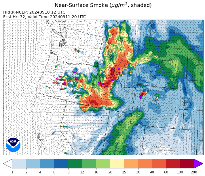
Source: HRRR Smoke
Conditions can change quickly as weather could stimulate active fires and the likelihood of new starts increases. Please keep track of concentrations at todaysair.mtdeq.us or the Fire and Smoke Map.
Current Wildfires
|
Incident |
State |
location |
acres |
containment |
|
Logan Fire - IDPAF |
Idaho |
West of Edwardsburg, Krassel Ranger District, Payette National Forest |
200 |
NA |
|
Frog - IDSTF |
Idaho |
Little Boulder Creek off the East Fork of the Salmon River |
1,500 |
0% |
|
Chimney Fire - IDEIX |
Idaho |
9 miles northwest of Fairfield, ID |
6,140 |
10% |
|
Wapiti Fire - IDBOF |
Idaho |
2 miles southwest of Grandjean, ID |
120,354 |
12% |
|
Lava Fire - IDBOF |
Idaho |
12 miles SW of Cascade, ID |
69,658 |
0% |
|
Limepoint Fire - IDPAF |
Idaho |
8 miles NE of Oxbow Dam |
33,075 |
95% |
|
Snag Fire - IDBOF |
Idaho |
9.5 miles East of Cascade, Idaho |
33,084 |
15% |
|
Goat Fire - IDBOF |
Idaho |
11 miles SE of Cascade, Idaho |
6,054 |
0% |
|
Dollar Fire - IDBOF |
Idaho |
18 miles NE of Cascade, Idaho |
4,308 |
8% |
|
Boulder Fire - IDBOF |
Idaho |
9 Miles Southwest of Cascade, Idaho. |
7,883 |
24% |
|
Middle Fork Complex Fire: Bulldog and Nellie - IDBOF |
Idaho |
9 miles east of Garden Valley, ID |
58,770 |
30% |
|
Moose Creek Complex - IDNCF |
Idaho |
East Moose creek Bridge to Elbow Bend impacted |
10,388 |
NA |
|
Surprise Fire - IDNCF |
Idaho |
Three and one-half miles NE of Hunter Peak, Fifteen miles NW of Darby, MT in the Selway-Bitterroot Wilderness |
763 |
NA |
|
Copper Fire - IDPAF |
Idaho |
NA |
315 |
NA |
|
Farrow Fire - IDPAF |
Idaho |
NA |
1,069 |
NA |
|
Burnt Creek Fire - IDPAF |
Idaho |
NA |
2,665 |
NA |
|
Parks Fire - IDPAF |
Idaho |
NA |
5,610 |
NA |
|
Moore Square Complex - IDNCF |
Idaho |
Both Fires are located in the Gospel-Hump Wilderness Area near Square Mountain |
3,093 |
0% |
|
Cracker Jack Complex - IDNCF |
Idaho |
All four fires are located within half a mile of each other: two and a half miles east of Concord, ID, less than a quarter acre east from Square Lake and less than a quarter acre west from Fish Lake. |
3,800 |
NA |
|
2024 Flat - IDIDS |
Idaho |
One mile east of Pioneerville, Idaho |
3,734 |
61% |
|
Bulltrout Fire - IDBOF |
Idaho |
15 miles WNW OF Stanley, ID |
271 |
92% |
|
Monumental Fire - IDPAF |
Idaho |
NA |
11 |
NA |
|
Robbin Fire - IDNCF |
Idaho |
Within Game Unit 12: located less than six and a half miles southwest of Powell Ranger Station and less than three and a half miles south of Wendover Campground |
NA |
NA |
|
Grave Butte Fire - IDNCF |
Idaho |
Within Game Unit 12: located ten miles west of Jerry Johnson Campground and about half a mile from National Forest Service Road #107 (Saddle Camp Road) |
10 |
NA |
|
Boulder Creek Fire - IDNCF |
Idaho |
Within Game Unit 12: located ten miles north of the Powell Ranger Station and 12 miles west of Lolo Hot Springs |
25 |
NA |
|
Bench Lake Fire - IDSTF |
Idaho |
8 miles south of Stanley, Idaho |
2,595 |
90% |
|
Shepp Fire - IDNCF |
Idaho |
Approximately 30 miles Southwest of Elk City, Idaho |
100 |
NA |
|
Black Eagle Fire - IDSCF |
Idaho |
21 miles west of Salmon |
3,451 |
0% |
|
Red Rock Fire - IDSCF |
Idaho |
15 miles west of Salmon, ID |
1,846 |
0% |
|
Sharrott Creek Fire - MTBRF |
Montana |
Three miles west of Stevensville, Montana |
3,193 |
NA |
|
Long Tom Fire - MTMTS |
Montana |
10 miles south of Anaconda, MT |
110 |
0% |
|
Johnson Fire - MTBRF |
Montana |
3 miles south of Springer Memorial Community in the East Fork of the Bitterroot |
6,301 |
NA |
|
McDermott - MTBDF |
Montana |
17 miles northwest of Philipsburg, MT |
319 |
NA |
|
Elkhorn Ridge - MTBRF |
Montana |
West Fork District |
3,125 |
0% |
|
Railroad-Daly Fire - MTBRF |
Montana |
Railroad Creek/ Skalkaho Creek confluence, 26 miles SE of Hamilton |
2,418 |
6% |
|
Marsh Creek - MTHLF |
Montana |
12 Miles Southeast of Lincoln, MT |
130 |
0% |
|
McElwain Fire - MTMTS |
Montana |
10 miles west of Helmville, MT |
116 |
75% |
|
Grouse - MTBDF |
Montana |
Ten miles southwest of Wise River, MT |
5,743 |
22% |
|
Magruder Ridge Fire - MTBRF |
Montana |
Selway Bitterroot Wilderness |
1,652 |
0% |
|
Remington Fire - MTGNF |
Montana |
14 miles NE of Leiter, WY, multiple counties in southeast Montana. |
196,368 |
88% |
|
Ratio Mountain - MTBDF |
Montana |
15 miles northwest of Whitehall, MT. |
1,226 |
NA |
|
Pentagon Fire - MTFNF |
Montana |
45 miles SE of Bigfork, MT |
62 |
0% |
|
Willamette Complex Fires - South - ORWIF |
Oregon |
Willamette Complex South fires are 8 miles north and 8 to 22 miles S-SE of Oakridge. |
22,943 |
NA |
|
Fossil Complex - OR95S |
Oregon |
1.5 miles NW of Spray;10 miles east of Fossil; 5 miles NE of Monument, Oregon |
15,552 |
3% |
|
North Willamette Complex - ORWIF |
Oregon |
Willamette National Forest |
4,631 |
NA |
|
Rail Ridge - OROCF |
Oregon |
Approx. 7 miles south of Dayville, OR |
157,759 |
11% |
|
Cottage Grove - Lane 1 - OR77S |
Oregon |
Approximately 16 miles SE of Springfield, OR |
25,927 |
99% |
|
Copperfield Fire - OR98S |
Oregon |
10 miles east of Chiloquin, Oregon |
3,822 |
86% |
|
Red Fire - ORDEF |
Oregon |
Diamond Peak Wilderness, 16 miles west, north-west of Crescent Oregon. |
1,289 |
0% |
|
Whisky Creek Fire - ORMHF |
Oregon |
East fork of Herman Creek, 6 miles SE of Cascade Locks, OR |
2,977 |
25% |
|
Devils Knob and Milepost 98 Fires - ORUPF |
Oregon |
5 miles southeast of Tiller, OR |
3,466 |
0% |
|
Shoe Fly Fire - OR95S |
Oregon |
6 Miles NE of Mitchell, Oregon |
26,463 |
32% |
|
Milepost 98 - ORUPF |
Oregon |
The MIiepost 98 fire is located approximately 1 mile north of Canyonville. |
328 |
0% |
|
Sandstone Fire - ORMHF |
Oregon |
9 miles SW of Ripplebrook, OR, on the Mt. Hood National Forest |
702 |
75% |
|
Diamond Complex - ORUPF |
Oregon |
18 miles southwest of Chemult, Oregon |
11,141 |
83% |
|
Wiley Flat - OROCF |
Oregon |
10 miles southeast of post, Oregon |
26,873 |
13% |
|
Homestead Complex - ORUPF |
Oregon |
Thirty miles northeast of Glide Oregon |
8,640 |
60% |
|
Middle Fork Fire - ORCLP |
Oregon |
Crater Lake National Park; Middle Fork area |
5,286 |
70% |
|
Two Cabin - OR95S |
Oregon |
4 Miles NE of Monument Oregon |
251 |
5% |
|
Crazy Creek - OROCF |
Oregon |
Crazy Creek:16 miles north of Paulina, OR |
86,968 |
95% |
|
Microwave Tower Fire - OR95S |
Oregon |
1 mile WSW of Mosier, OR |
1,313 |
95% |
|
Lone Rock Fire - ORPRD |
Oregon |
Lonerock stretching to west of HWY 207 and south to HWY 19 |
137,222 |
98% |
|
Dixon Fire - ORUPF |
Oregon |
Tiller, Oregon |
1,970 |
87% |
|
Battle Mountain Complex - OR97S |
Oregon |
West and south of Ukiah, OR |
183,026 |
94% |
|
Warner Peak Fire - ORSHR |
Oregon |
3 miles East of Plush, on the Hart Mountain Antelope Refuge |
65,866 |
85% |
|
Town Gulch - ORWWF |
Oregon |
Eagle Creek Rd Area, 24 Miles East of Baker City OR, 8 Miles N of Richland, OR |
18,220 |
89% |
|
Cliff Mountain - ORWWF |
Oregon |
25 Miles East of Joseph, Oregon |
1,108 |
75% |
|
Porcupine Fire - ORBUD |
Oregon |
Porcupine Reservoir |
6,491 |
95% |
|
Badland Complex 2024 - ORVAD |
Oregon |
Baker County, Oregon |
54,563 |
99% |
|
Durkee Fire - ORVAD |
Oregon |
1 mile west of Durkee, Oregon |
294,265 |
95% |
|
Ruby Fire - WANCP |
Washington |
On Ruby Mountain in North Cascade National Park by Diablo and Ross Lake, 9 miles East of Newhalem |
1,300 |
0% |
|
Williams Mine Fire-GPNF - WAGPF |
Washington |
3.5 miles NNW of Trout Lake WA |
13,089 |
31% |
|
Swauk Creek - WASES |
Washington |
Kittitas County, WA |
150 |
0% |
|
Pincer Two Fire - WAMSF |
Washington |
Johannesburg Mountain. 1 Mile East of Mineral Park Campground |
211 |
0% |
|
Huckleberry Ridge Fire - WAPCS |
Washington |
20 miles south of Pe Ell, Washington |
293 |
0% |
|
Pioneer - WASES |
Washington |
Approximate start 10 miles southeast of Stehekin, WA |
38,735 |
23% |
|
Easy Fire - WAOWF |
Washington |
North Cascades Hwy 20 Corridor, 17 air miles west of Mazama, WA |
2,130 |
36% |
|
Retreat - WASES |
Washington |
14 miles WSE of Naches, WA |
45,601 |
85% |
|
Six Mile - WACOA |
Washington |
Two miles east of Nine Mile Hellgate Road, near the head of Cottonwood Creek |
113 |
90% |
|
Stranger Creek II - WACOA |
Washington |
NA |
66 |
90% |
|
Lodgepole - WAOWF |
Washington |
16 miles west of Cliffdell, WA |
35 |
6% |
|
Cougar Creek Fire - WASES |
Washington |
1 mile west of Hwy 129 and Grand Ronde river intersection |
24,091 |
80% |
|
Kachess Complex - WAOWF |
Washington |
12 miles west of Cle Elum drainage |
23 |
NA |
Source: Inciweb
Tags: Smoke Forecast 2024