
Smoke Forecast for Monday, September 9, 2024 9:30 AM
Current Conditions
Montana DEQ has issued an Air Quality Alert until 8AM Tuesday for Broadwater, Cascade, Deer Lodge, Granite, Jefferson, Lake, Lewis and Clark, Mineral, Missoula, Powell, Ravalli, Sanders, Silver Bow, and Teton Counties because of elevated particulate levels from wildfire smoke.
Surface smoke and haze are widespread across much of Western Montana early Monday. Expect air quality to be a concern through Tuesday.
The Lava, Boulder, and Goat fires burning in Central Idaho are exhibiting extreme fire behavior again Monday. The Wapiti fire is currently the largest wildfire in Idaho. It’s burning in the mountains of the Boise National Forest of Central Idaho. It has burned nearly 116,000 acres and is only 12% contained.
Several fires burning in Western Montana continue to grow. The Grouse fire burning just east of Wisdom has burned around 5,700 acres and is 22% contained. The Johnson fire burning just east of Sula has burned nearly 6,300 acres and is 25% contained. The Sharrott Creek fire just west of Stevensville is the largest staffed wildfire in the state, with 355 personnel assigned to it. has burned around 3,000 acres and is 36% contained. The Ratio Mountain fire burning east of Butte has burned more than 1,200 acres. It is 54% contained. The Daly fire burning in the Sapphire Mountains east of the Bitterroot Valley was active again on Sunday. It has burned around 2,100 acres and is 6% contained. Lastly, the Mile Marker 104 fire burning northwest of Missoula has burned 400 acres and is 80% contained.
At 9:00 AM Monday, Miles City, Broadus, Bozeman, Dillon, Cut Bank, Columbia Falls, Thompson Falls were enduring Moderate air quality. Seeley Lake was experiencing air that is Unhealthy for Sensitive Groups. Hamilton, Missoula, Frenchtown, Butte, Helena, Sleeping Giant, Lewistown, Havre, and Choteau were enduring Unhealthy air.
Monday morning’s satellite shows widespread heavy smoke across much of Montana, Idaho, and Oregon.
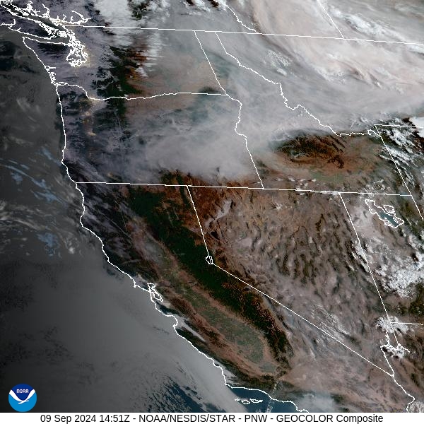
Source: NOAA
Forecast
Heavy surface smoke will continue to impact air quality around much of the state again on Monday. Winds perk up a bit by Monday afternoon, and it should help to mix out some of the heavy surface smoke over the valleys. Numerous active wildfires burning over Western Montana and Idaho will send additional smoke across the region, leading to deteriorating air quality.
Starting Tuesday, better ventilation arrives as a Pacific trough approaches. It should help to begin to scour out the surface smoke in many of the valleys. Temperatures will begin to cool on Tuesday. The combination of cooler air and higher relative humidity should moderate fire behavior and begin to limit smoke production.
By Wednesday, a trough of low pressure marches across the Treasure State. It will provide some beneficial rain for the entire region. Some areas in Idaho and Northwest Montana could receive more than an inch of rain from this storm. Cooler air and widespread rainfall should help to ease fire weather concerns across the area. Air quality is expected to improve for the Northern Rockies thanks to the cooler and wetter pattern. Another trough of low pressure is possible by early next week, bringing additional rainfall for the state. Stay tuned!
By late Tuesday, the HRRR smoke model shows heavy surface smoke lingering over the western half of Montana.
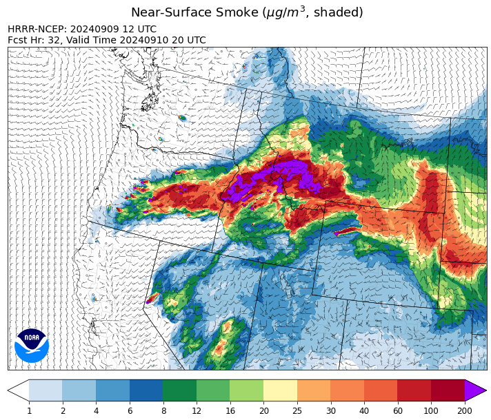
Source: HRRR Smoke
Conditions can change quickly as weather could stimulate active fires and the likelihood of new starts increases. Please keep track of concentrations at todaysair.mtdeq.us or the Fire and Smoke Map.
Current Wildfires
|
Incident |
State |
location |
acres |
containment |
|
Wapiti Fire - IDBOF |
Idaho |
2 miles southwest of Grandjean, ID |
120,354 |
12% |
|
Lava Fire - IDBOF |
Idaho |
12 miles SW of Cascade, ID |
46,733 |
0% |
|
Chimney Fire - IDEIX |
Idaho |
9 miles northwest of Fairfield, ID |
4,892 |
10% |
|
Limepoint Fire - IDPAF |
Idaho |
8 miles NE of Oxbow Dam |
33,075 |
95% |
|
Goat Fire - IDBOF |
Idaho |
11 miles SE of Cascade, Idaho |
6,054 |
0% |
|
Snag Fire - IDBOF |
Idaho |
9.5 miles East of Cascade, Idaho |
33,014 |
16% |
|
Dollar Fire - IDBOF |
Idaho |
18 miles NE of Cascade, Idaho |
4,297 |
8% |
|
Boulder Fire - IDBOF |
Idaho |
9 Miles Southwest of Cascade, Idaho. |
4,159 |
24% |
|
Middle Fork Complex Fire: Bulldog and Nellie - IDBOF |
Idaho |
9 miles east of Garden Valley, ID |
58,770 |
30% |
|
Parks Fire - IDPAF |
Idaho |
NA |
3,850 |
NA |
|
Farrow Fire - IDPAF |
Idaho |
NA |
900 |
NA |
|
Burnt Creek Fire - IDPAF |
Idaho |
NA |
2,666 |
NA |
|
Copper Fire - IDPAF |
Idaho |
NA |
315 |
NA |
|
Moore Square Complex - IDNCF |
Idaho |
Both Fires are located in the Gospel-Hump Wilderness Area near Square Mountain |
3,093 |
0% |
|
Cracker Jack Complex - IDNCF |
Idaho |
All four fires are located within half a mile of each other: two and a half miles east of Concord, ID, less than a quarter acre east from Square Lake and less than a quarter acre west from Fish Lake. |
3,800 |
NA |
|
Moose Creek Complex - IDNCF |
Idaho |
East Moose creek Bridge to Elbow Bend impacted |
10,388 |
NA |
|
Surprise Fire - IDNCF |
Idaho |
Three and one-half miles NE of Hunter Peak, Fifteen miles NW of Darby, MT in the Selway-Bitterroot Wilderness |
40 |
NA |
|
2024 Flat - IDIDS |
Idaho |
One mile east of Pioneerville, Idaho |
3,734 |
61% |
|
Bulltrout Fire - IDBOF |
Idaho |
15 miles WNW OF Stanley, ID |
271 |
92% |
|
Monumental Fire - IDPAF |
Idaho |
NA |
11 |
NA |
|
Robbin Fire - IDNCF |
Idaho |
Within Game Unit 12: located less than six and a half miles southwest of Powell Ranger Station and less than three and a half miles south of Wendover Campground |
NA |
NA |
|
Grave Butte Fire - IDNCF |
Idaho |
Within Game Unit 12: located ten miles west of Jerry Johnson Campground and about half a mile from National Forest Service Road #107 (Saddle Camp Road) |
10 |
NA |
|
Boulder Creek Fire - IDNCF |
Idaho |
Within Game Unit 12: located ten miles north of the Powell Ranger Station and 12 miles west of Lolo Hot Springs |
25 |
NA |
|
Bench Lake Fire - IDSTF |
Idaho |
8 miles south of Stanley, Idaho |
2,595 |
90% |
|
Shepp Fire - IDNCF |
Idaho |
Approximately 30 miles Southwest of Elk City, Idaho |
100 |
NA |
|
Oxbow Fire - IDPAF |
Idaho |
Near Oxbow dam in Hells Canyon |
6,000 |
NA |
|
Black Eagle Fire - IDSCF |
Idaho |
21 miles west of Salmon |
2,410 |
0% |
|
Red Rock Fire - IDSCF |
Idaho |
15 miles west of Salmon, ID |
707 |
0% |
|
McDermott - MTBDF |
Montana |
17 miles northwest of Philipsburg, MT |
216 |
NA |
|
McElwain Fire - MTMTS |
Montana |
10 miles west of Helmville, MT |
116 |
75% |
|
Sharrott Creek Fire - MTBRF |
Montana |
Three miles west of Stevensville, Montana |
3,018 |
NA |
|
Railroad-Daly Fire - MTBRF |
Montana |
Railroad Creek/ Skalkaho Creek confluence, 26 miles SE of Hamilton |
2,418 |
4% |
|
Grouse - MTBDF |
Montana |
Ten miles southwest of Wise River, MT |
5,743 |
22% |
|
Johnson Fire - MTBRF |
Montana |
Johnson fire is located in and out of the A-P wilderness & community of Springer |
6,301 |
0% |
|
Marsh Creek - MTHLF |
Montana |
12 Miles Southeast of Lincoln, MT |
110 |
0% |
|
Elkhorn Ridge - MTBRF |
Montana |
West Fork District |
3,125 |
0% |
|
Magruder Ridge Fire - MTBRF |
Montana |
Selway Bitterroot Wilderness |
1,652 |
0% |
|
Remington Fire - MTGNF |
Montana |
14 miles NE of Leiter, WY, multiple counties in southeast Montana. |
196,368 |
88% |
|
Ratio Mountain - MTBDF |
Montana |
15 miles northwest of Whitehall, MT. |
1,226 |
NA |
|
Big Hollow Fire - MTMTS |
Montana |
36 miles southwest of Dillon, MT |
3,435 |
90% |
|
Pentagon Fire - MTFNF |
Montana |
45 miles SE of Bigfork, MT |
62 |
0% |
|
Muir Creek Fire - MTGNP |
Montana |
20 miles southeast of West Glacier, MT and east of the Middle Fork of the Flathead River |
30 |
0% |
|
Sandstone Fire - ORMHF |
Oregon |
9 miles SW of Ripplebrook, OR, on the Mt. Hood National Forest |
702 |
75% |
|
Whisky Creek Fire - ORMHF |
Oregon |
East fork of Herman Creek, 6 miles SE of Cascade Locks, OR |
2,935 |
25% |
|
Homestead Complex - ORUPF |
Oregon |
Thirty miles northeast of Glide Oregon |
8,640 |
60% |
|
North Willamette Complex - ORWIF |
Oregon |
Willamette National Forest |
4,631 |
NA |
|
Fossil Complex - OR95S |
Oregon |
1.5 miles NW of Spray;10 miles east of Fossil; 5 miles NE of Monument, Oregon |
4,421 |
3% |
|
Willamette Complex Fires - South - ORWIF |
Oregon |
Willamette Complex South fires are 8 miles north and 8 to 22 miles S-SE of Oakridge. |
22,422 |
NA |
|
Copperfield Fire - OR98S |
Oregon |
10 miles east of Chiloquin, Oregon |
3,822 |
77% |
|
Middle Fork Fire - ORCLP |
Oregon |
Crater Lake National Park; Middle Fork area |
5,286 |
70% |
|
Diamond Complex - ORUPF |
Oregon |
18 miles southwest of Chemult, Oregon |
11,141 |
83% |
|
Devils Knob and Milepost 98 Fires - ORUPF |
Oregon |
5 miles southeast of Tiller, OR |
3,466 |
0% |
|
Shoe Fly Fire - OR95S |
Oregon |
6 Miles NE of Mitchell, Oregon |
26,409 |
26% |
|
Rail Ridge - OROCF |
Oregon |
Approx. 7 miles south of Dayville, OR |
135,067 |
7% |
|
Cottage Grove - Lane 1 - OR77S |
Oregon |
Approximately 16 miles SE of Springfield, OR |
25,884 |
97% |
|
Red Fire - ORDEF |
Oregon |
Diamond Peak Wilderness, 16 miles west, north-west of Crescent Oregon. |
1,289 |
0% |
|
Wiley Flat - OROCF |
Oregon |
10 miles southeast of post, Oregon |
20,774 |
3% |
|
Two Cabin - OR95S |
Oregon |
4 Miles NE of Monument Oregon |
251 |
5% |
|
Crazy Creek - OROCF |
Oregon |
Crazy Creek:16 miles north of Paulina, OR |
86,968 |
95% |
|
Microwave Tower Fire - OR95S |
Oregon |
1 mile WSW of Mosier, OR |
1,313 |
95% |
|
Lone Rock Fire - ORPRD |
Oregon |
Lonerock stretching to west of HWY 207 and south to HWY 19 |
137,222 |
98% |
|
Dixon Fire - ORUPF |
Oregon |
Tiller, Oregon |
1,970 |
87% |
|
Battle Mountain Complex - OR97S |
Oregon |
West and south of Ukiah, OR |
183,026 |
94% |
|
Warner Peak Fire - ORSHR |
Oregon |
3 miles East of Plush, on the Hart Mountain Antelope Refuge |
65,866 |
85% |
|
Town Gulch - ORWWF |
Oregon |
Eagle Creek Rd Area, 24 Miles East of Baker City OR, 8 Miles N of Richland, OR |
18,220 |
89% |
|
Cliff Mountain - ORWWF |
Oregon |
25 Miles East of Joseph, Oregon |
1,108 |
75% |
|
Porcupine Fire - ORBUD |
Oregon |
Porcupine Reservoir |
6,491 |
95% |
|
Badland Complex 2024 - ORVAD |
Oregon |
Baker County, Oregon |
54,563 |
99% |
|
Durkee Fire - ORVAD |
Oregon |
1 mile west of Durkee, Oregon |
294,265 |
95% |
|
Cow Valley Fire - ORVAD |
Oregon |
West of Brogan and Northwest of Vale |
133,490 |
99% |
|
Larch Creek Fire - OR95S |
Oregon |
Friend, OR, a rural community |
18,286 |
81% |
|
Ruby Fire - WANCP |
Washington |
On Ruby Mountain in North Cascade National Park by Diablo and Ross Lake, 9 miles East of Newhalem |
1,217 |
0% |
|
Williams Mine Fire-GPNF - WAGPF |
Washington |
3.5 miles NNW of Trout Lake WA |
13,057 |
31% |
|
Pioneer - WASES |
Washington |
Approximate start 10 miles southeast of Stehekin, WA |
38,735 |
23% |
|
Huckleberry Ridge Fire - WAPCS |
Washington |
20 miles south of Pe Ell, Washington |
293 |
0% |
|
Pincer Two Fire - WAMSF |
Washington |
Johannesburg Mountain. 1 Mile East of Mineral Park Campground |
211 |
0% |
|
Easy Fire - WAOWF |
Washington |
North Cascades Hwy 20 Corridor, 17 air miles west of Mazama, WA |
2,130 |
36% |
|
Retreat - WASES |
Washington |
14 miles WSE of Naches, WA |
45,601 |
85% |
|
Six Mile - WACOA |
Washington |
Two miles east of Nine Mile Hellgate Road, near the head of Cottonwood Creek |
113 |
90% |
|
Stranger Creek II - WACOA |
Washington |
NA |
66 |
90% |
|
Lodgepole - WAOWF |
Washington |
16 miles west of Cliffdell, WA |
35 |
6% |
|
Cougar Creek Fire - WASES |
Washington |
1 mile west of Hwy 129 and Grand Ronde river intersection |
24,091 |
80% |
|
Kachess Complex - WAOWF |
Washington |
12 miles west of Cle Elum drainage |
23 |
NA |
Source: Inciweb
Tags: Smoke Forecast 2024