
Smoke Forecast for Sunday, September 8, 2024 9:00 AM
Current Conditions
The Montana DEQ is issuing an Air Quality Alert through Monday at 8AM for Deer Lodge, Granite, Mineral, Missoula, and Ravalli Counties because of elevated particulate levels from wildfire smoke.
Surface smoke and haze will remain widespread over much of the Treasure State again on Sunday. A system will spread scattered storms and a bit more wind for the area by Sunday afternoon.
There are numerous active fires burning in the Bitterroot Mountains of Idaho and Montana. These fires will continue to spread smoke into portions of Southwest Montana. The largest of the group is the Wye fire burning 30 miles west of Hamilton. This fire has burned almost 10,000 acres and is 0% contained.
The Wapiti fire is currently the largest wildfire in Idaho. It’s burning in the mountains of the Boise National Forest of Central Idaho. It has burned nearly 115,000 acres and is only 12% contained.
Several fires burning in Western Montana continue to grow. The Grouse fire burning just east of Wisdom has burned around 5,700 acres and is 22% contained. The Johnson fire burning just east of Sula has burned nearly 5,500 acres and is 25% contained. The Sharrott Creek fire just west of Stevensville is the largest staffed wildfire in the state, with 499 personnel assigned to it. has burned around 3,000 acres and is 36% contained. The Ratio Mountain fire burning east of Butte has burned more than 1,200 acres. It is 54% contained. The Daly fire burning in the Sapphire Mountains east of the Bitterroot Valley was active again on Saturday. It has burned around 2,100 acres and is 6% contained. Lastly, the Mile Marker 104 fire burning northwest of Missoula has burned 400 acres and is 60% contained.
At 8:00 AM Saturday, Libby, Thompson Falls, Cut Bank, Columbia Falls, Frenchtown, Missoula, Helena, Sleeping Giant, Butte, Lewistown, Billings, Seeley Lake, Butte, and Broadus were enduring Moderate air quality. Bozeman was experiencing air that is Unhealthy for Sensitive Groups. Hamilton was enduring Unhealthy air.
Sunday morning’s satellite shows widespread smoke over much of Montana from regional wildfires.
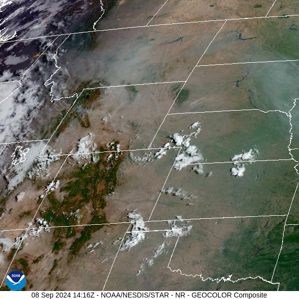
Source: NOAA
Forecast
Unseasonably warm air, gusty winds, and dry fuels will lead to another day of active fire behavior on many regional wildfires. A disturbance will slide across the state late on Sunday. It will bring a bit more wind and produce some widely scattered showers and storms. Much of the precipitation will evaporate before reaching the surface due to very dry air. The flow will shift to the southwest, pushing much of the heaviest surface smoke into parts of Mineral and Missoula Counties at times.
Isolated showers and thunderstorms are possible again on Monday as the ridge gradually starts to weaken. Gusty winds, dry fuels, and warm temperatures will produce another round of active fire behavior. Expect surface smoke to be an issue, particularly across Southwest Montana.
A major pattern shift to our weather is likely starting Wednesday as a trough pushes into the state. Some much-needed rain will fall across much of the Northern Rockies, along with cooler temperatures. The pattern shift should help to moderate fire behavior and reduce surface smoke concentrations. Stay tuned!
By late Monday, the HRRR smoke model shows heavy surface smoke surging further east into much of Montana.
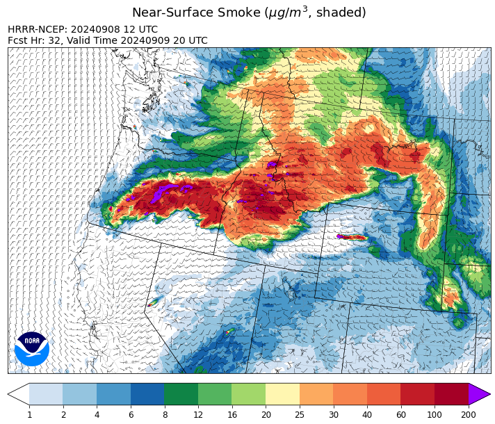
Source: HRRR Smoke
Conditions can change quickly as weather could stimulate active fires and the likelihood of new starts increases. Please keep track of concentrations at todaysair.mtdeq.us or the Fire and Smoke Map.
Current Wildfires
|
Incident |
State |
location |
acres |
containment |
|
Limepoint Fire - IDPAF |
Idaho |
8 miles NE of Oxbow Dam |
33,016 |
95% |
|
Wapiti Fire - IDBOF |
Idaho |
2 miles southwest of Grandjean, ID |
116,788 |
12% |
|
Snag Fire - IDBOF |
Idaho |
9.5 miles East of Cascade, Idaho |
32,737 |
15% |
|
Goat Fire - IDBOF |
Idaho |
11 miles SE of Cascade, Idaho |
5,427 |
0% |
|
Dollar Fire - IDBOF |
Idaho |
18 miles NE of Cascade, Idaho |
4,261 |
8% |
|
Boulder Fire - IDBOF |
Idaho |
9 Miles Southwest of Cascade, Idaho. |
4,128 |
24% |
|
Lava Fire - IDBOF |
Idaho |
12 miles SW of Cascade, ID |
1,611 |
0% |
|
Moore Square Complex - IDNCF |
Idaho |
Both Fires are located in the Gospel-Hump Wilderness Area near Square Mountain |
3,093 |
0% |
|
Middle Fork Complex Fire: Bulldog and Nellie - IDBOF |
Idaho |
9 miles east of Garden Valley, ID |
58,351 |
30% |
|
Chimney Fire - IDEIX |
Idaho |
9 miles northwest of Fairfield, ID |
3,247 |
10% |
|
Copper Fire - IDPAF |
Idaho |
NA |
315 |
NA |
|
Burnt Creek Fire - IDPAF |
Idaho |
NA |
2,666 |
NA |
|
Farrow Fire - IDPAF |
Idaho |
NA |
900 |
NA |
|
Parks Fire - IDPAF |
Idaho |
NA |
3,850 |
NA |
|
Cracker Jack Complex - IDNCF |
Idaho |
All four fires are located within half a mile of each other: two and a half miles east of Concord, ID, less than a quarter acre east from Square Lake and less than a quarter acre west from Fish Lake. |
3,800 |
NA |
|
Moose Creek Complex - IDNCF |
Idaho |
East Moose creek Bridge to Elbow Bend impacted |
10,388 |
NA |
|
Red Rock Fire - IDSCF |
Idaho |
15 miles west of Salmon, ID |
273 |
0% |
|
Black Eagle Fire - IDSCF |
Idaho |
21 miles west of Salmon |
2,081 |
0% |
|
Johnson Fire - MTBRF |
Montana |
Johnson fire is located in and out of the A-P wilderness & community of Springer |
6,301 |
0% |
|
Sharrott Creek Fire - MTBRF |
Montana |
Three miles west of Stevensville, Montana |
3,018 |
NA |
|
Marsh Creek - MTHLF |
Montana |
12 Miles Southeast of Lincoln, MT |
110 |
0% |
|
McDermott - MTBDF |
Montana |
17 miles northwest of Philipsburg, MT |
216 |
NA |
|
Grouse - MTBDF |
Montana |
Ten miles southwest of Wise River, MT |
5,743 |
22% |
|
Railroad-Daly Fire - MTBRF |
Montana |
Railroad Creek/ Skalkaho Creek confluence, 26 miles SE of Hamilton |
2,068 |
4% |
|
Elkhorn Ridge - MTBRF |
Montana |
West Fork District |
3,125 |
0% |
|
Magruder Ridge Fire - MTBRF |
Montana |
Selway Bitterroot Wilderness |
1,652 |
0% |
|
Remington Fire - MTGNF |
Montana |
14 miles NE of Leiter, WY, multiple counties in southeast Montana. |
196,368 |
88% |
|
Ratio Mountain - MTBDF |
Montana |
15 miles northwest of Whitehall, MT. |
1,226 |
NA |
|
McElwain Fire - MTMTS |
Montana |
10 miles west of Helmville, MT |
116 |
60% |
|
Willamette Complex Fires - South - ORWIF |
Oregon |
Willamette Complex South fires are 8 miles north and 8 to 22 miles S-SE of Oakridge. |
21,858 |
NA |
|
Whisky Creek Fire - ORMHF |
Oregon |
East fork of Herman Creek, 6 miles SE of Cascade Locks, OR |
2,856 |
25% |
|
Rail Ridge - OROCF |
Oregon |
Approx. 7 miles south of Dayville, OR |
135,067 |
7% |
|
North Willamette Complex - ORWIF |
Oregon |
Willamette National Forest |
4,631 |
NA |
|
Copperfield Fire - OR98S |
Oregon |
10 miles east of Chiloquin, Oregon |
3,822 |
68% |
|
Fossil Complex - OR95S |
Oregon |
1.5 miles NW of Spray;10 miles east of Fossil; 5 miles NE of Monument, Oregon |
752 |
0% |
|
Shoe Fly Fire - OR95S |
Oregon |
6 Miles NE of Mitchell, Oregon |
25,142 |
19% |
|
Wiley Flat - OROCF |
Oregon |
10 miles southeast of post, Oregon |
20,774 |
3% |
|
Sandstone Fire - ORMHF |
Oregon |
9 miles SW of Ripplebrook, OR, on the Mt. Hood National Forest |
702 |
75% |
|
Red Fire - ORDEF |
Oregon |
Diamond Peak Wilderness, 16 miles west, north-west of Crescent Oregon. |
1,289 |
0% |
|
Devils Knob and Milepost 98 Fires - ORUPF |
Oregon |
5 miles southeast of Tiller, OR |
1,200 |
0% |
|
Cottage Grove - Lane 1 - OR77S |
Oregon |
Approximately 16 miles SE of Springfield, OR |
25,305 |
97% |
|
Homestead Complex - ORUPF |
Oregon |
Thirty miles northeast of Glide Oregon |
6,156 |
60% |
|
Middle Fork Fire - ORCLP |
Oregon |
Crater Lake National Park; Middle Fork area |
5,286 |
62% |
|
Diamond Complex - ORUPF |
Oregon |
18 miles southwest of Chemult, Oregon |
11,141 |
81% |
|
Two Cabin - OR95S |
Oregon |
4 Miles NE of Monument Oregon |
251 |
5% |
|
Crazy Creek - OROCF |
Oregon |
Crazy Creek:16 miles north of Paulina, OR |
86,968 |
95% |
|
Microwave Tower Fire - OR95S |
Oregon |
1 mile WSW of Mosier, OR |
1,313 |
95% |
|
Ruby Fire - WANCP |
Washington |
On Ruby Mountain in North Cascade National Park by Diablo and Ross Lake, 9 miles East of Newhalem |
1,217 |
0% |
|
Williams Mine Fire-GPNF - WAGPF |
Washington |
3.5 miles NNW of Trout Lake WA |
13,049 |
31% |
|
Pioneer - WASES |
Washington |
Approximate start 10 miles southeast of Stehekin, WA |
38,735 |
23% |
|
Huckleberry Ridge Fire - WAPCS |
Washington |
20 miles south of Pe Ell, Washington |
343 |
0% |
|
Pincer Two Fire - WAMSF |
Washington |
Johannesburg Mountain. 1 Mile East of Mineral Park Campground |
211 |
0% |
Source: Inciweb
Tags: Smoke Forecast 2024