
Smoke Forecast for Thursday, September 5, 2024 9:30 AM
Current Conditions
High pressure will dominate the weather pattern across the Northern Rockies in the coming days. Numerous active fires continue to burn across Montana and Idaho, but light winds should keep the bulk of the surface smoke from Idaho’s wildfires south of Montana.
There are numerous active fires burning in the Bitterroot Mountains of Idaho and Montana. These fires will continue to spread smoke into portions of Western Montana in the coming days. The largest of the group is the Wye fire burning 30 miles west of Hamilton. This fire has burned almost 9,500 acres and is 0% contained.
The Wapiti fire is currently the largest wildfire in Idaho. It’s burning in the mountains of the Boise National Forest of Central Idaho. It has burned more than 110,000 acres and is only 8% contained.
Several fires burning in Western Montana are slowly expanding. The Grouse fire burning just east of Wisdom has burned around 5,000 acres and is 22% contained. The Johnson fire burning just east of Sula has burned more than 4,300 acres and is 0% contained. The Sharrott Creek fire just west of Stevensville is the largest staffed wildfire in the state, with 626 personnel assigned to it. has burned more than 2,800 acres and is 23% contained. Lastly, the Ratio Mountain fire burning east of Butte has burned more than 1,200 acres. It is 54% contained.
The Remington fire started in Wyoming on August 22. It is burning in mainly grassland and scrubland. The fire quickly expanded north into Montana and has now burned nearly 200,000 acres. The Remington fire is now 88% contained.
At 9:00 AM Thursday, Libby, Frenchtown, Hamilton, Bozeman, and Broadus were enduring Moderate air quality.
Thursday morning’s satellite shows light smoke over Western Montana, with heavier smoke over Washington, Idaho, and Oregon.
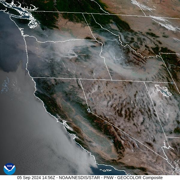
Source: NOAA
Forecast
A ridge of high pressure will continue to dominate the weather pattern across the Northern Rockies Thursday and into the weekend. It will produce unseasonably warm air, with highs well into the 80s and 90s. Winds will be light and variable, so the typical diurnal smoke patterns can be expected. For valleys adjacent to active wildfires like the Bitterroot and Big Hole, smoke will tend to drain overnight, with the worst air quality by late morning. As the inversion lifts, better mixing will help to scour out the surface smoke, leading to better afternoon air quality.
By late Sunday, a southwesterly flow will return to the region. This will begin to send smoke from fires burning upstream in Idaho, back into the Treasure State. Surface concentrations of smoke could deteriorate as a result, particularly across the western half of the state. The flow will also provide more moisture and introduce the potential for a few scattered thunderstorms.
By Wednesday, most forecast models bring a trough of low pressure into Montana. This will lead to progressively cooler air and provide chances for much-needed rain. Stay tuned!
By late Friday, the HRRR smoke model shows smoke impacting Southwest Montana from fires burning across the region.
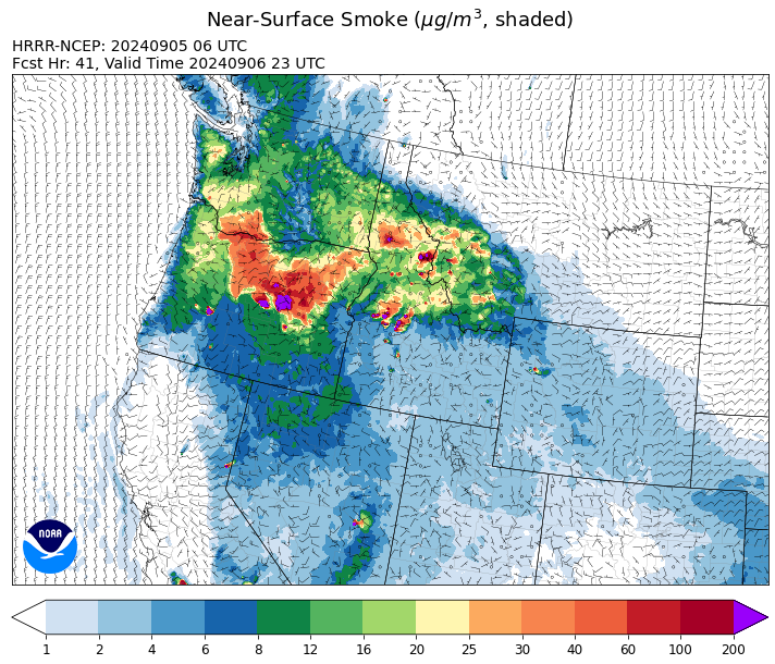
Source: HRRR Smoke
Conditions can change quickly as weather could stimulate active fires and the likelihood of new starts increases. Please keep track of concentrations at todaysair.mtdeq.us or the Fire and Smoke Map.
Current Wildfires
|
Incident |
State |
location |
acres |
containment |
|
Goat Fire - IDBOF |
Idaho |
11 miles SE of Cascade, Idaho |
3,952 |
0% |
|
Dollar Fire - IDBOF |
Idaho |
18 miles NE of Cascade, Idaho |
4,137 |
8% |
|
Wapiti Fire - IDBOF |
Idaho |
2 miles southwest of Grandjean, ID |
112,321 |
8% |
|
Middle Fork Complex Fire: Bulldog, Nellie, Anderson - IDBOF |
Idaho |
9 miles east of Garden Valley, ID |
57,836 |
28% |
|
Boulder Fire - IDBOF |
Idaho |
9 Miles Southwest of Cascade, Idaho. |
3,842 |
24% |
|
Snag Fire - IDBOF |
Idaho |
9.5 miles East of Cascade, Idaho |
32,204 |
12% |
|
Limepoint Fire - IDPAF |
Idaho |
8 miles NE of Oxbow Dam |
32,998 |
95% |
|
Anchor Fire - IDNCF |
Idaho |
About half way between Hanover Mountain and Square Mountain in the Gospel Hump Wilderness |
400 |
NA |
|
Ace Butte Fire - IDNCF |
Idaho |
Approximately 30 miles Southeast of Grangeville, Idaho |
152 |
NA |
|
Wye Fire - IDNCF |
Idaho |
East Moose creek Bridge to Elbow Bend impacted |
7,739 |
NA |
|
Cracker Jack Complex - IDNCF |
Idaho |
All four fires are located within half a mile of each other: two and a half miles east of Concord, ID, less than a quarter acre east from Square Lake and less than a quarter acre west from Fish Lake. |
1,345 |
NA |
|
Wolf Creek Fire - IDPAF |
Idaho |
11 Miles NW of Cascade, ID |
1,154 |
95% |
|
Parks Fire - IDPAF |
Idaho |
NA |
3,850 |
NA |
|
Farrow Fire - IDPAF |
Idaho |
NA |
900 |
NA |
|
Burnt Creek Fire - IDPAF |
Idaho |
NA |
2,497 |
NA |
|
Mineral Fire - IDPAF |
Idaho |
The fire is located approximately 12 miles north of Steck Park along the Snake River. |
15,000 |
0% |
|
Surprise Fire - IDNCF |
Idaho |
Three and one-half miles NE of Hunter Peak, Fifteen miles NW of Darby, MT in the Selway-Bitterroot Wilderness |
40 |
NA |
|
Red Rock Fire - IDSCF |
Idaho, United States |
15 miles west of Salmon, ID |
189 |
0% |
|
Black Eagle Fire - IDSCF |
Idaho, United States |
21 miles west of Salmon |
1,949 |
NA |
|
Remington Fire - MTGNF |
Montana |
14 miles NE of Leiter, WY, multiple counties in southeast Montana. |
196,368 |
88% |
|
Sharrott Creek Fire - MTBRF |
Montana |
Three miles west of Stevensville, Montana |
2,873 |
25% |
|
Railroad-Daly Fire - MTBRF |
Montana |
Railroad Creek/ Skalkaho Creek confluence, 26 miles SE of Hamilton |
1,670 |
0% |
|
Magruder Ridge Fire - MTBRF |
Montana |
Selway Bitterroot Wilderness |
800 |
0% |
|
Johnson Fire - MTBRF |
Montana |
Johnson fire is located in and out of the A-P wilderness & community of Springer |
4,325 |
0% |
|
Ratio Mountain - MTBDF |
Montana |
15 miles northwest of Whitehall, MT. |
1,158 |
NA |
|
McElwain Fire - MTMTS |
Montana |
10 miles west of Helmville, MT |
116 |
60% |
|
Grouse - MTBDF |
Montana |
Ten miles southwest of Wise River, MT |
4,822 |
22% |
|
Elkhorn Ridge - MTBRF |
Montana |
West Fork District |
2,482 |
0% |
|
Marsh Creek - MTHLF |
Montana |
12 Miles Southeast of Lincoln, MT |
88 |
0% |
|
Big Hollow Fire - MTMTS |
Montana |
36 miles southwest of Dillon, MT |
3,435 |
90% |
|
Whisky Creek Fire - ORMHF |
Oregon |
East fork of Herman Creek, 6 miles SE of Cascade Locks, OR |
2,105 |
25% |
|
Two Cabin - OR95S |
Oregon |
4 Miles NE of Monument Oregon |
251 |
3% |
|
Shoe Fly Fire - OR95S |
Oregon |
6 Miles NE of Mitchell, Oregon |
21,623 |
5% |
|
North Willamette Complex - ORWIF |
Oregon |
Willamette National Forest |
4,615 |
NA |
|
Diamond Complex - ORUPF |
Oregon |
18 miles southwest of Chemult, Oregon |
11,141 |
81% |
|
Red Fire - ORDEF |
Oregon |
Diamond Peak Wilderness, 16 miles west, north-west of Crescent Oregon. |
877 |
0% |
|
Middle Fork Fire - ORCLP |
Oregon |
Crater Lake National Park; Middle Fork area |
5,286 |
58% |
|
Homestead Complex - ORUPF |
Oregon |
Thirty miles northeast of Glide Oregon |
5,918 |
60% |
|
Copperfield Fire - OR98S |
Oregon |
10 miles east of Chiloquin, Oregon |
3,802 |
26% |
|
Rail Ridge - OROCF |
Oregon |
Approx. 7 miles south of Dayville, OR |
61,433 |
0% |
|
Willamette Complex Fires - South - ORWIF |
Oregon |
Willamette Complex South fires are 8 miles north and 8 to 22 miles S-SE of Oakridge. |
13,644 |
64% |
|
Sandstone Fire - ORMHF |
Oregon |
9 miles SW of Ripplebrook, OR, on the Mt. Hood National Forest |
702 |
75% |
|
Cottage Grove - Lane 1 - OR77S |
Oregon |
Approximately 16 miles SE of Springfield, OR |
25,305 |
97% |
|
Wiley Flat - OROCF |
Oregon |
10 miles southeast of post, Oregon |
14,000 |
0% |
|
Crazy Creek - OROCF |
Oregon |
Crazy Creek:16 miles north of Paulina, OR |
86,968 |
95% |
|
Microwave Tower Fire - OR95S |
Oregon |
1 mile WSW of Mosier, OR |
1,313 |
95% |
|
Ruby Fire - WANCP |
Washington |
On Ruby Mountain in North Cascade National Park by Diablo and Ross Lake, 9 miles East of Newhalem |
959 |
0% |
|
Williams Mine Fire-GPNF - WAGPF |
Washington |
3.5 miles NNW of Trout Lake WA |
12,418 |
31% |
|
Pincer Two Fire - WAMSF |
Washington |
Johannesburg Mountain. 1 Mile East of Mineral Park Campground |
211 |
0% |
|
Pioneer - WASES |
Washington |
Approximate start 10 miles southeast of Stehekin, WA |
38,735 |
23% |
Source: Inciweb
Tags: Smoke Forecast 2024