
Smoke Forecast for September 4, 2024 9:30 AM
Current Conditions
A trough of low pressure exits the state on Wednesday. A scattered shower or storm is possible over the central and eastern portions of the state.
There are numerous active fires burning in the Bitterroot Mountains of Idaho and Montana. These fires will continue to spread smoke into portions of Western Montana in the coming days. The largest of the group is the Wye fire burning 30 miles west of Hamilton. This fire has burned more than 9,200 acres and is 0% contained.
There are several fires burning in Western Montana continue to slowly expand. The Grouse fire burning just east of Wisdom has burned more than 4,800 acres and is 22% contained. The Johnson fire burning just east of Sula has burned more than 3,800 acres and is 0% contained. It is largely burning on land with no known fire history, so there is plenty of fuel for this fire. The Sharrott Creek fire just west of Stevensville is the largest staffed wildfire in the state, with 650 personnel assigned to it. has burned around 2,400 acres and is 0% contained. Lastly, the Ratio Mountain fire burning east of Butte has burned more than 1,200 acres. The fire received a good soaking on Tuesday, and the blaze is now 54% contained.
The Remington fire started in Wyoming on August 22. It is burning in mainly grassland and scrubland. The fire quickly expanded north into Montana and has now burned nearly 200,000 acres. The Remington fire is now 88% contained.
At 9:00 AM Wednesday air quality is Unhealthy in Sidney and Glendive. Air quality is Unhealthy for Sensitive Groups in Hamilton. Libby, Thompson Falls, Frenchtown, Columbia Falls, Cut Bank, Great Falls, Sleeping Giant, Butte, Dillon, Malta, Miles City, and Broadus were enduring Moderate air quality.
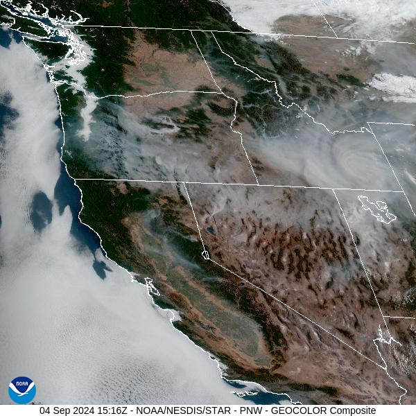
Wednesday morning’s satellite shows light smoke over Western Montana, with heavier smoke over the southern half of Idaho.
Source: NOAA
Forecast
A trough of low pressure is shifting east across the Treasure State on Wednesday. It will produce rain and scattered thunderstorms, primarily east of I-15. Some of the stronger storms will produce frequent lightning and gusty winds. Apart from areas adjacent to wildfires, Western Montana will enjoy a reprieve from heavy surface smoke with the upper-level flow remaining out of the north on Wednesday.
On Thursday and Friday, a ridge of high pressure builds over Montana. It will begin a dramatic warming trend, with temperatures 10-15 degrees above average. Despite this ridge, the upper-level flow will still be out of the west, which should keep much of the smoke from large wildfires burning in Idaho south of Montana. Areas adjacent to wildfires, like the Bitterroot and Big Hole Valleys, will see the usual diurnal fluctuations in surface smoke. High pressure will allow the smoke to pool and drain into the valleys, leading to deteriorating air quality overnight and early in the morning.
Starting Saturday, the upper-level flow turns around to the southwest. This will lead to more widespread surface smoke impacts over Montana due to the massive wildfires burning in Idaho. Expect deteriorating air quality across the western half of the state for the upcoming weekend. The ridge finally breaks down by Tuesday or Wednesday of next week. This should lead to a cooler and wetter weather pattern across the Treasure State. It should also help to reduce smoke production and moderate fire behavior on existing wildfires in the region. Stay tuned!
By late Thursday, the HRRR smoke model shows much of the heaviest smoke remaining south and west of Montana.
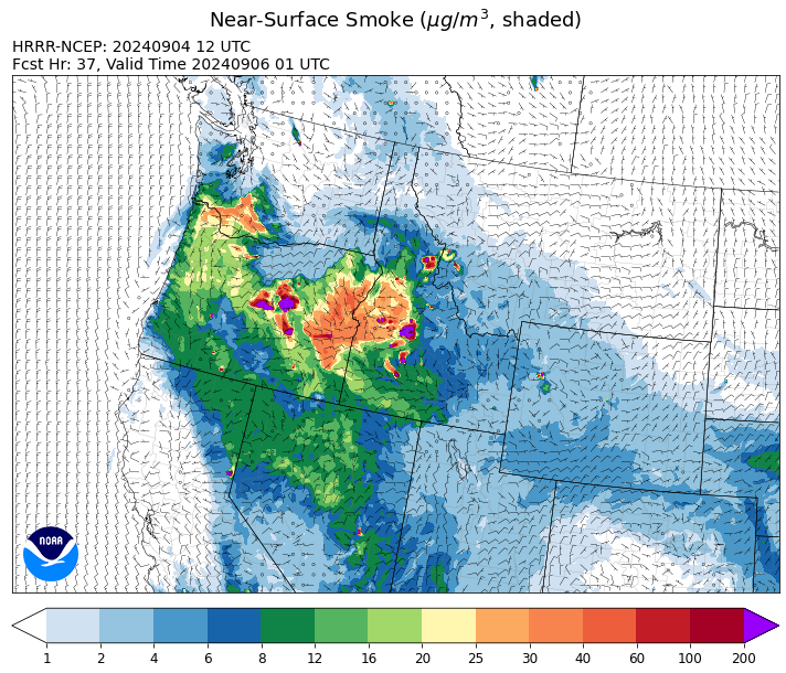
Source: HRRR Smoke
Conditions can change quickly as weather could stimulate active fires and the likelihood of new starts increases. Please keep track of concentrations at todaysair.mtdeq.us or the Fire and Smoke Map.
Current Wildfires
|
Incident |
State |
location |
acres |
containment |
|
Wapiti Fire - IDBOF |
Idaho |
2 miles southwest of Grandjean, ID |
110,425 |
4% |
|
Goat Fire - IDBOF |
Idaho |
11 miles SE of Cascade, Idaho |
3,265 |
0% |
|
Snag Fire - IDBOF |
Idaho |
9.5 miles East of Cascade, Idaho |
31,809 |
1% |
|
Dollar Fire - IDBOF |
Idaho |
18 miles NE of Cascade, Idaho |
4,010 |
0% |
|
Boulder Fire - IDBOF |
Idaho |
9 Miles Southwest of Cascade, Idaho. |
2,868 |
36% |
|
Limepoint Fire - IDPAF |
Idaho |
8 miles NE of Oxbow Dam |
32,998 |
95% |
|
Middle Fork Complex Fire: Bulldog, Nellie, Anderson - IDBOF |
Idaho |
9 miles east of Garden Valley, ID |
57,466 |
23% |
|
Anchor Fire - IDNCF |
Idaho |
About half way between Hanover Mountain and Square Mountain in the Gospel Hump Wilderness |
400 |
NA |
|
Ace Butte Fire - IDNCF |
Idaho |
Approximately 30 miles Southeast of Grangeville, Idaho |
152 |
NA |
|
Wye Fire - IDNCF |
Idaho |
East Moose creek Bridge to Elbow Bend impacted |
7,739 |
NA |
|
Cracker Jack Complex - IDNCF |
Idaho |
All four fires are located within half a mile of each other: two and a half miles east of Concord, ID, less than a quarter acre east from Square Lake and less than a quarter acre west from Fish Lake. |
1,345 |
NA |
|
Wolf Creek Fire - IDPAF |
Idaho |
11 Miles NW of Cascade, ID |
1,154 |
95% |
|
Parks Fire - IDPAF |
Idaho |
NA |
3,850 |
NA |
|
Farrow Fire - IDPAF |
Idaho |
NA |
900 |
NA |
|
Burnt Creek Fire - IDPAF |
Idaho |
NA |
2,497 |
NA |
|
Mineral Fire - IDPAF |
Idaho |
The fire is located approximately 12 miles north of Steck Park along the Snake River. |
15,000 |
0% |
|
Surprise Fire - IDNCF |
Idaho |
Three and one-half miles NE of Hunter Peak, Fifteen miles NW of Darby, MT in the Selway-Bitterroot Wilderness |
40 |
NA |
|
Red Rock Fire - IDSCF |
Idaho, United States |
15 miles west of Salmon, ID |
165 |
0% |
|
Black Eagle Fire - IDSCF |
Idaho, United States |
21 miles west of Salmon |
1,922 |
NA |
|
Sharrott Creek Fire - MTBRF |
Montana |
Three miles west of Stevensville, Montana |
2,873 |
23% |
|
Johnson Fire - MTBRF |
Montana |
Johnson fire is located in and out of the A-P wilderness & community of Springer |
3,812 |
0% |
|
Grouse - MTBDF |
Montana |
Ten miles southwest of Wise River, MT |
4,822 |
22% |
|
Remington Fire - MTGNF |
Montana |
14 miles NE of Leiter, WY, multiple counties in southeast Montana. |
196,368 |
88% |
|
Railroad-Daly Fire - MTBRF |
Montana |
Railroad Creek/ Skalkaho Creek confluence, 26 miles SE of Hamilton |
160 |
0% |
|
Elkhorn Ridge - MTBRF |
Montana |
West Fork District |
2,482 |
0% |
|
Magruder Ridge Fire - MTBRF |
Montana |
Selway Bitterroot Wilderness |
800 |
0% |
|
Marsh Creek - MTHLF |
Montana |
12 Miles Southeast of Lincoln, MT |
88 |
0% |
|
Ratio Mountain - MTBDF |
Montana |
15 miles northwest of Whitehall, MT. |
1,158 |
NA |
|
McElwain Fire - MTMTS |
Montana |
10 miles west of Helmville, MT |
116 |
50% |
|
Big Hollow Fire - MTMTS |
Montana |
36 miles southwest of Dillon, MT |
3,435 |
90% |
|
Rail Ridge - OROCF |
Oregon |
Approx. 7 miles south of Dayville, OR |
61,433 |
0% |
|
North Willamette Complex - ORWIF |
Oregon |
Willamette National Forest |
4,588 |
NA |
|
Whisky Creek Fire - ORMHF |
Oregon |
East fork of Herman Creek, 6 miles SE of Cascade Locks, OR |
2,097 |
25% |
|
Middle Fork Fire - ORCLP |
Oregon |
Crater Lake National Park; Middle Fork area |
5,286 |
55% |
|
Diamond Complex - ORUPF |
Oregon |
18 miles southwest of Chemult, Oregon |
11,141 |
79% |
|
Willamette Complex Fires - South - ORWIF |
Oregon |
Willamette Complex South fires are 8 miles north and 8 to 22 miles S-SE of Oakridge. |
13,644 |
64% |
|
Copperfield Fire - OR98S |
Oregon |
10 miles east of Chiloquin, Oregon |
3,656 |
0% |
|
Red Fire - ORDEF |
Oregon |
Diamond Peak Wilderness, 16 miles west, north-west of Crescent Oregon. |
851 |
0% |
|
Cottage Grove - Lane 1 - OR77S |
Oregon |
Approximately 16 miles SE of Springfield, OR |
25,305 |
97% |
|
Homestead Complex - ORUPF |
Oregon |
Thirty miles northeast of Glide Oregon |
5,918 |
60% |
|
Sandstone Fire - ORMHF |
Oregon |
9 miles SW of Ripplebrook, OR, on the Mt. Hood National Forest |
702 |
75% |
|
Shoe Fly Fire - OR95S |
Oregon |
NA |
20,247 |
0% |
|
Crazy Creek - OROCF |
Oregon |
Crazy Creek:16 miles north of Paulina, OR |
86,968 |
95% |
|
Microwave Tower Fire - OR95S |
Oregon |
1 mile WSW of Mosier, OR |
1,313 |
95% |
|
Williams Mine Fire-GPNF - WAGPF |
Washington |
3.5 miles NNW of Trout Lake WA |
12,661 |
31% |
|
Ruby Fire - WANCP |
Washington |
On Ruby Mountain in North Cascade National Park by Diablo and Ross Lake, 9 miles East of Newhalem |
959 |
0% |
|
Pioneer - WASES |
Washington |
Approximate start 10 miles southeast of Stehekin, WA |
38,735 |
23% |
|
Pincer Two Fire - WAMSF |
Washington |
Johannesburg Mountain. 1 Mile East of Mineral Park Campground |
211 |
0% |
|
Easy Fire - WAOWF |
Washington |
North Cascades Hwy 20 Corridor, 17 air miles west of Mazama, WA |
2,130 |
36% |
|
Retreat - WASES |
Washington |
14 miles WSE of Naches, WA |
45,601 |
85% |
Source: Inciweb
Tags: Smoke Forecast 2024