
Smoke Forecast for Tuesday, September 3, 2024 9:30 AM
Current Conditions
A trough of low pressure will swing east across Montana on Tuesday. It will produce scattered showers and thunderstorms. The low will provide better mixing and should help to reduce the amount of surface smoke.
There are numerous active fires burning in the Bitterroot Mountains of Idaho and Montana. These fires will continue to spread smoke into portions of Western Montana in the coming days. The largest of the group is the Wye fire burning 30 miles west of Hamilton. This fire has burned more than 9,200 acres and is 0% contained.
On Tuesday, there were four fires burning in Western Montana that exhibited active fire behavior. The Grouse fire burning just east of Wisdom has burned more than 4,200 acres and is 22% contained. The Johnson fire burning just east of Sula has burned more than 3,700 acres and is 0% contained. It is largely burning on land with no known fire history, so there is plenty of fuel for this fire. The Sharrott Creek fire just west of Stevensville has burned around 2,400 acres and is 0% contained. Lastly, the Ratio Mountain fire burning east of Butte has burned more than 1,100 acres and is 22% contained.
The Remington fire started in Wyoming on August 22. It is burning in mainly grassland and scrubland. The fire quickly expanded north into Montana and has now burned nearly 200,000 acres. The Remington fire is now 86% contained.
At 9:00 AM Tuesday, Missoula, Columbia Falls, Frenchtown, Libby, Thompson Falls, Seeley Lake, Helena, Choteau, Cut Bank, Great Falls, and Lewistown were enduring Moderate air quality.
Tuesday morning’s satellite shows areas an area of low pressure moving across the Northern Rockies, with heavy smoke over Idaho and Oregon.
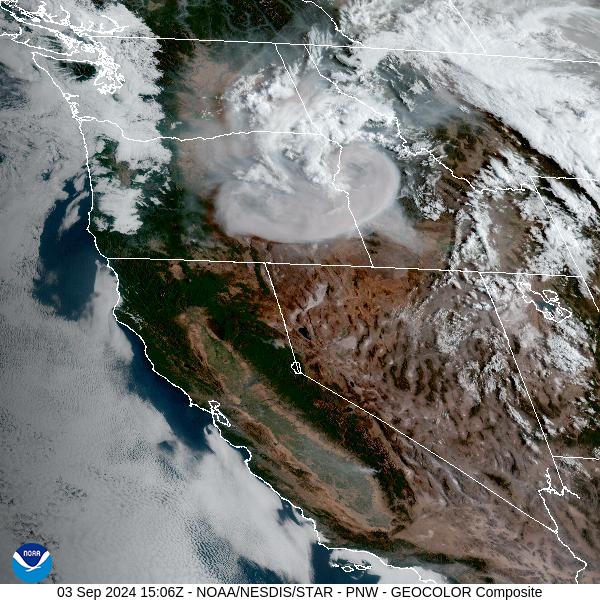
Source: NOAA
Forecast
A trough of low pressure shifts east over the Treasure State on Tuesday. It will provide scattered showers and storms. The main threats from these storms will be gusty outflow winds from a few of the stronger storms. The trough should shift the flow to the northwest, preventing wildfire smoke from impacting communities further away from the Idaho/Montana border that were seeing impacts over the weekend.
As the area of low-pressure swings east, a ridge of high pressure builds back over the Northern Rockies Wednesday and Thursday. This ridge will bring another round of unseasonably warm temperatures. The combination of dry fuels, gusty winds, and warm air will lead to additional growth on regional wildfires and increased smoke production. Under this pattern, air quality will likely deteriorate, particularly in communities adjacent to wildfires.
The ridge shifts east by Sunday as the flow turns more southwesterly. This will provide some monsoonal moisture for the Northern Rockies, with daily chances for afternoon storms. It will also send smoke from fires burning in Idaho into Western Montana. Stay tuned!
By late Wednesday, the HRRR smoke model shows a departing trough shifting much of the heaviest smoke south into Idaho.
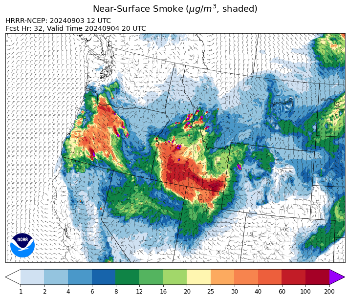
Source: HRRR Smoke
Conditions can change quickly as weather could stimulate active fires and the likelihood of new starts increases. Please keep track of concentrations at todaysair.mtdeq.us or the Fire and Smoke Map.
Current Wildfires
|
Incident |
State |
location |
acres |
containment |
|
Wapiti Fire - IDBOF |
Idaho |
2 miles southwest of Grandjean, ID |
108,017 |
0% |
|
Limepoint Fire - IDPAF |
Idaho |
8 miles NE of Oxbow Dam |
32,973 |
93% |
|
Boulder Fire - IDBOF |
Idaho |
9 Miles Southwest of Cascade, Idaho. |
2,868 |
36% |
|
Mineral Fire - IDPAF |
Idaho |
The fire is located approximately 12 miles north of Steck Park along the Snake River. |
3,000 |
0% |
|
Goat Fire - IDBOF |
Idaho |
11 miles SE of Cascade, Idaho |
3,265 |
0% |
|
Snag Fire - IDBOF |
Idaho |
9.5 miles East of Cascade, Idaho |
31,809 |
1% |
|
Dollar Fire - IDBOF |
Idaho |
18 miles NE of Cascade, Idaho |
4,010 |
0% |
|
Middle Fork Complex Fire: Bulldog, Nellie, Anderson - IDBOF |
Idaho |
9 miles east of Garden Valley, ID |
56,806 |
14% |
|
Burnt Creek Fire - IDPAF |
Idaho |
NA |
2,497 |
NA |
|
Farrow Fire - IDPAF |
Idaho |
NA |
900 |
NA |
|
Parks Fire - IDPAF |
Idaho |
NA |
3,850 |
NA |
|
Wolf Creek Fire - IDPAF |
Idaho |
11 Miles NW of Cascade, ID |
1,154 |
95% |
|
Surprise Fire - IDNCF |
Idaho |
Three and one-half miles NE of Hunter Peak, Fifteen miles NW of Darby, MT in the Selway-Bitterroot Wilderness |
40 |
NA |
|
Wye Fire - IDNCF |
Idaho |
East Moose creek Bridge to Elbow Bend impacted |
7,739 |
NA |
|
Cracker Jack Complex - IDNCF |
Idaho |
All four fires are located within half a mile of each other: two and a half miles east of Concord, ID, less than a quarter acre east from Square Lake and less than a quarter acre west from Fish Lake. |
1,345 |
NA |
|
Anchor Fire - IDNCF |
Idaho |
About half way between Hanover Mountain and Square Mountain in the Gospel Hump Wilderness |
400 |
NA |
|
Black Eagle Fire - IDSCF |
Idaho, United States |
21 miles west of Salmon |
2,000 |
NA |
|
Sharrott Creek Fire - MTBRF |
Montana |
Three miles west of Stevensville, Montana |
2,399 |
NA |
|
Remington Fire - MTGNF |
Montana |
14 miles NE of Leiter, WY, multiple counties in southeast Montana. |
196,368 |
86% |
|
Marsh Creek - MTHLF |
Montana |
12 Miles Southeast of Lincoln, MT |
88 |
0% |
|
Johnson Fire - MTBRF |
Montana |
Johnson fire is located in and out of the A-P wilderness & community of Springer |
3,753 |
0% |
|
Magruder Ridge Fire - MTBRF |
Montana |
Selway Bitterroot Wilderness |
800 |
0% |
|
Railroad-Daly Fire - MTBRF |
Montana |
Railroad Creek/ Skalkaho Creek confluence, 26 miles SE of Hamilton |
160 |
0% |
|
Elkhorn Ridge - MTBRF |
Montana |
West Fork District |
2,482 |
0% |
|
Ratio Mountain - MTBDF |
Montana |
15 miles northwest of Whitehall, MT. |
1,058 |
NA |
|
Grouse - MTBDF |
Montana |
Ten miles southwest of Wise River, MT |
4,822 |
22% |
|
McElwain Fire - MTMTS |
Montana |
10 miles west of Helmville, MT |
116 |
50% |
|
Big Hollow Fire - MTMTS |
Montana |
36 miles southwest of Dillon, MT |
3,435 |
90% |
|
Diamond Complex - ORUPF |
Oregon |
18 miles southwest of Chemult, Oregon |
11,141 |
78% |
|
North Willamette Complex - ORWIF |
Oregon |
Willamette National Forest |
4,588 |
NA |
|
Red Fire - ORDEF |
Oregon |
Diamond Peak Wilderness, 16 miles west, north-west of Crescent Oregon. |
851 |
0% |
|
Homestead Complex - ORUPF |
Oregon |
Thirty miles northeast of Glide Oregon |
5,918 |
60% |
|
Copperfield Fire - OR98S |
Oregon |
10 miles east of Chiloquin, Oregon |
3,241 |
0% |
|
Cottage Grove - Lane 1 - OR77S |
Oregon |
Approximately 16 miles SE of Springfield, OR |
25,305 |
93% |
|
Willamette Complex Fires - South - ORWIF |
Oregon |
Willamette Complex South fires are 8 miles north and 8 to 22 miles S-SE of Oakridge. |
13,242 |
64% |
|
Sandstone Fire - ORMHF |
Oregon |
9 miles SW of Ripplebrook, OR, on the Mt. Hood National Forest |
702 |
75% |
|
Whisky Creek Fire - ORMHF |
Oregon |
East fork of Herman Creek, 6 miles SE of Cascade Locks, OR |
2,092 |
25% |
|
Middle Fork Fire - ORCLP |
Oregon |
Crater Lake National Park; Middle Fork area |
5,282 |
46% |
|
Crazy Creek - OROCF |
Oregon |
Crazy Creek:16 miles north of Paulina, OR |
86,968 |
95% |
|
Microwave Tower Fire - OR95S |
Oregon |
1 mile WSW of Mosier, OR |
1,313 |
95% |
|
Ruby Fire - WANCP |
Washington |
On Ruby Mountain in North Cascade National Park by Diablo and Ross Lake, 9 miles East of Newhalem |
959 |
0% |
|
Williams Mine Fire-GPNF - WAGPF |
Washington |
3.5 miles NNW of Trout Lake WA |
12,161 |
31% |
|
Pioneer - WASES |
Washington |
Approximate start 10 miles southeast of Stehekin, WA |
38,735 |
23% |
|
Pincer Two Fire - WAMSF |
Washington |
Johannesburg Mountain. 1 Mile East of Mineral Park Campground |
211 |
0% |
|
Easy Fire - WAOWF |
Washington |
North Cascades Hwy 20 Corridor, 17 air miles west of Mazama, WA |
2,130 |
36% |
|
Retreat - WASES |
Washington |
14 miles WSE of Naches, WA |
45,601 |
85% |
Source: Inciweb
Tags: Smoke Forecast 2024