
Smoke Forecast for Monday, September 2, 2024 1:30 PM
Current Conditions
An Air Quality Alert is in effect for Beaverhead, Ravalli, Silver Bow, Deer Lodge, Granite, Missoula, Mineral, Lake, and Sanders Counties until 4PM Tuesday because of elevated particulate levels from wildfires smoke.
An area of low pressure will move across the Northern Rockies on Monday. It will bring scattered storms and gusty winds, which could lead to extreme fire behavior on existing wildfires.
There are numerous active fires burning in the Bitterroot Mountains of Idaho and Montana. These fires will continue to spread smoke into portions of Western Montana in the coming days. The largest of the group is the Wye fire burning 30 miles west of Hamilton. This fire has burned more than 7,300 acres and is 0% contained.
On Monday, there were four fires burning in Western Montana that exhibited active fire behavior. The Grouse fire burning just east of Wisdom has burned more than 4,200 acres and is 22% contained. The Johnson fire burning just east of Sula has burned more than 3,500 acres and is 0% contained. It is largely burning on land with no known fire history, so there is plenty of fuel for this fire. The Sharrott Creek fire just west of Stevensville has burned over 1,700 acres and is 0% contained. Lastly, the Ratio Mountain fire burning east of Butte has burned more than 1,000 acres and is 22% contained.
The Remington fire started in Wyoming on August 22. It is burning in mainly grassland and scrubland. The fire quickly expanded north into Montana and has now burned nearly 200,000 acres. The Remington fire is now 81% contained.
At 1:00 PM Monday, Frenchtown, Columbia Falls, Seeley Lake, Helena, Great Falls, Lewistown, Billings, Bozeman, Dillon were enduring Moderate air quality. Missoula and Butte were experiencing air that is Unhealthy for Sensitive Groups. Hamilton was experiencing air that is considered Very Unhealthy.
Monday afternoon’s satellite shows areas of heavy smoke over Western Montana as a trough of low pressure provides clouds and showers.
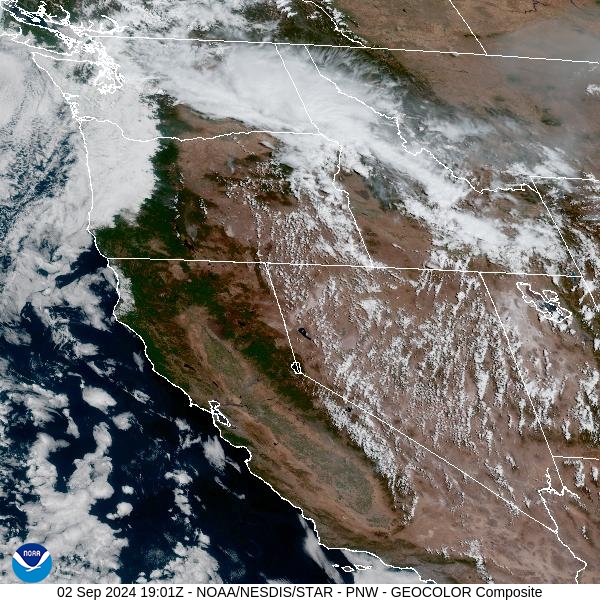
Source: NOAA
Forecast
An area of low pressure will march across the Northern Rockies on Monday and Tuesday. It will provide scattered showers and storms. Some of the stronger storms will produce gusty outflow winds, with gusts between 40-50 miles per hour. The combination of dry fuels, gusty winds, and unseasonably warm temperatures will continue to produce active fire behavior on existing wildfires. Because of very dry air, the potential for dry thunderstorms has increased across the Treasure State Monday afternoon and evening. Any of these storms has the potential to create new fire starts.
On Tuesday, atmospheric moisture will increase across the region. This will lead to more widespread showers and thunderstorms. These storms will again bring the threat for gusty outflow winds, producing erratic behavior on wildfires. Temperatures will cool a bit and relative humidity will gradually increase, reducing the threat of dramatic fire growth.
On Wednesday, the trough will remain over much of Montana. It will keep precipitation chances in the forecast and produce seasonable temperatures for the region. Surface winds will be out of the northwest, keeping the bulk of the smoke south of Montana at least temporarily. This will provide some improvements to air quality across Western Montana.
By the end of the week, a ridge of high pressure builds over the Northern Rockies. It will bring another round of unseasonable warmth to the area. The combination of warm temperatures, dry fuels, and gusty winds will bring the threat for rapid fire growth to existing wildfires. Stay tuned!
By late Tuesday, the HRRR smoke model shows a trough shifting some of the heavier smoke further east in Montana.
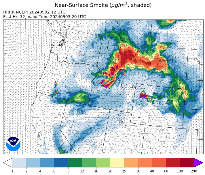
Source: HRRR Smoke
Conditions can change quickly as weather could stimulate active fires and the likelihood of new starts increases. Please keep track of concentrations at todaysair.mtdeq.us or the Fire and Smoke Map.
Current Wildfires
|
Incident |
State |
location |
acres |
containment |
|
Goat Fire - IDBOF |
Idaho |
11 miles SE of Cascade, Idaho |
2,964 |
0% |
|
Snag Fire - IDBOF |
Idaho |
9.5 miles East of Cascade, Idaho |
30,324 |
3% |
|
Boulder Fire - IDBOF |
Idaho |
9 Miles Southwest of Cascade, Idaho. |
2,393 |
57% |
|
Dollar Fire - IDBOF |
Idaho |
18 miles NE of Cascade, Idaho |
3,483 |
0% |
|
Wapiti Fire - IDBOF |
Idaho |
2 miles southwest of Grandjean, ID |
107,986 |
0% |
|
Middle Fork Complex Fire: Bulldog, Nellie, Anderson - IDBOF |
Idaho |
9 miles east of Garden Valley, ID |
56,806 |
14% |
|
Burnt Creek Fire - IDPAF |
Idaho |
NA |
2,497 |
NA |
|
Farrow Fire - IDPAF |
Idaho |
NA |
900 |
NA |
|
Parks Fire - IDPAF |
Idaho |
NA |
3,850 |
NA |
|
Limepoint Fire - IDPAF |
Idaho |
8 miles NE of Oxbow Dam |
32,973 |
93% |
|
Wolf Creek Fire - IDPAF |
Idaho |
11 Miles NW of Cascade, ID |
1,154 |
95% |
|
Surprise Fire - IDNCF |
Idaho |
Three and one-half miles NE of Hunter Peak, Fifteen miles NW of Darby, MT in the Selway-Bitterroot Wilderness |
40 |
NA |
|
Wye Fire - IDNCF |
Idaho |
East Moose creek Bridge to Elbow Bend impacted |
7,739 |
NA |
|
Cracker Jack Complex - IDNCF |
Idaho |
All four fires are located within half a mile of each other: two and a half miles east of Concord, ID, less than a quarter acre east from Square Lake and less than a quarter acre west from Fish Lake. |
1,345 |
NA |
|
Anchor Fire - IDNCF |
Idaho |
About half way between Hanover Mountain and Square Mountain in the Gospel Hump Wilderness |
400 |
NA |
|
2024 Flat - IDIDS |
Idaho |
One mile east of Pioneerville, Idaho |
3,734 |
61% |
|
Johnson Fire - MTBRF |
Montana |
3 miles west of the Springer Memorial Community in the East Fork on the Bitterroot NF |
3,753 |
0% |
|
Magruder Ridge Fire - MTBRF |
Montana |
Selway Bitterroot Wilderness |
800 |
0% |
|
Railroad-Daly Fire - MTBRF |
Montana |
Railroad Creek/ Skalkaho Creek confluence, 26 miles SE of Hamilton |
160 |
0% |
|
Sharrott Creek Fire - MTBRF |
Montana |
Three miles west of Stevensville, Montana |
1,775 |
NA |
|
Elkhorn Ridge - MTBRF |
Montana |
West Fork District |
2,482 |
0% |
|
Ratio Mountain - MTBDF |
Montana |
15 miles northwest of Whitehall, MT. |
1,058 |
NA |
|
Grouse - MTBDF |
Montana |
Ten miles southwest of Wise River, MT |
4,822 |
22% |
|
Remington Fire - MTGNF |
Montana |
14 miles NE of Leiter, WY, multiple counties in southeast Montana. |
196,368 |
81% |
|
Marsh Creek - MTHLF |
Montana |
12 Miles Southeast of Lincoln, MT |
25 |
0% |
|
McElwain Fire - MTMTS |
Montana |
10 miles west of Helmville, MT |
116 |
50% |
|
Big Hollow Fire - MTMTS |
Montana |
36 miles southwest of Dillon, MT |
3,435 |
90% |
|
Sandstone Fire - ORMHF |
Oregon |
9 miles SW of Ripplebrook, OR, on the Mt. Hood National Forest |
702 |
75% |
|
Middle Fork Fire - ORCLP |
Oregon |
Crater Lake National Park; Middle Fork area |
5,282 |
46% |
|
Diamond Complex - ORUPF |
Oregon |
18 miles southwest of Chemult, Oregon |
11,141 |
78% |
|
North Willamette Complex - ORWIF |
Oregon |
Willamette National Forest |
4,588 |
NA |
|
Homestead Complex - ORUPF |
Oregon |
Thirty miles northeast of Glide Oregon |
5,913 |
60% |
|
Crazy Creek - OROCF |
Oregon |
Crazy Creek:16 miles north of Paulina, OR |
86,968 |
95% |
|
Whisky Creek Fire - ORMHF |
Oregon |
East fork of Herman Creek, 6 miles SE of Cascade Locks, OR |
2,092 |
25% |
|
Willamette Complex Fires - South - ORWIF |
Oregon |
Willamette Complex South fires are 8 miles north and 8 to 22 miles S-SE of Oakridge. |
13,242 |
64% |
|
Red Fire - ORDEF |
Oregon |
Diamond Peak Wilderness, 16 miles west, north-west of Crescent Oregon. |
784 |
0% |
|
Cottage Grove - Lane 1 - OR77S |
Oregon |
Approximately 16 miles SE of Springfield, OR |
25,305 |
93% |
|
Microwave Tower Fire - OR95S |
Oregon |
1 mile WSW of Mosier, OR |
1,313 |
95% |
|
Lone Rock Fire - ORPRD |
Oregon |
Lonerock stretching to west of HWY 207 and south to HWY 19 |
137,222 |
98% |
|
Pincer Two Fire - WAMSF |
Washington |
Johannesburg Mountain. 1 Mile East of Mineral Park Campground |
211 |
0% |
|
Williams Mine Fire-GPNF - WAGPF |
Washington |
3.5 miles NNW of Trout Lake WA |
11,904 |
31% |
|
Ruby Fire - WANCP |
Washington |
On Ruby Mountain in North Cascade National Park by Diablo and Ross Lake, 9 miles East of Newhalem |
959 |
0% |
|
Pioneer - WASES |
Washington |
Approximate start 10 miles southeast of Stehekin, WA |
38,735 |
23% |
|
Easy Fire - WAOWF |
Washington |
North Cascades Hwy 20 Corridor, 17 air miles west of Mazama, WA |
2,130 |
36% |
|
Retreat - WASES |
Washington |
14 miles WSE of Naches, WA |
45,601 |
85% |
Source: Inciweb
Tags: Smoke Forecast 2024