
Smoke Forecast for Sunday, September 1, 2024 1:30 PM
Current Conditions
An Air Quality Alert is in effect for Beaverhead, Ravalli, Silver Bow, Deer Lodge, Granite, Missoula, Mineral, Lake, and Sanders Counties until 4PM Monday because of elevated particulate levels from wildfires smoke.
Active wildfires continue to burn across Western Montana and central and southern Idaho. These fires are responsible for the smoke that is filling in across several Montana counties.
There are numerous active fires burning in the Bitterroot Mountains of Idaho and Montana. These fires will continue to spread smoke into portions of Western Montana in the coming days. The largest of the group is the Wye fire burning 30 miles west of Hamilton. This fire has burned more than 7,300 acres and is 0% contained.
On Sunday, there were four fires burning in Western Montana that exhibited active fire behavior. The Grouse fire burning just east of Wisdom has burned more than 4,200 acres and is 22% contained. The Johnson fire burning just east of Sula has burned more than 1,400 acres and is 0% contained. The Sharrott Creek fire just west of Stevensville has burned over 1,400 acres and is 0% contained. Lastly, the Ratio Mountain fire burning east of Butte has burned more than 1,000 acres and is 9% contained.
The Remington fire started in Wyoming last week. It is burning in mainly grassland and scrubland. The fire quickly expanded north into Montana over the weekend and has now burned nearly 200,000 acres. The Remington is now 81% contained.
At 1:00 PM Sunday, Missoula, Butte, Dillon, Great Falls, Bozeman, and West Yellowstone were enduring Moderate air quality. Hamilton was experiencing air that is considered Unhealthy.
Sunday afternoon’s satellite shows areas of heavy smoke over Western Montana from wildfires burning across the region.
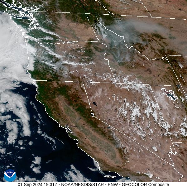
Source: NOAA
Forecast
Near record warmth, dry fuels, and gusty winds will create dangerous fire weather conditions around the Northern Rockies through Monday night. Smoke from wildfires in Idaho and Western Montana will produce unhealthy amounts of smoke in several counties. Surface concentrations of smoke will gradually deteriorate across a winder swath of Montana through late Monday, as a southwesterly flow lingers.
A trough swings across the region starting on Monday. It will provide scattered showers and thunderstorms, particularly over the higher terrain. Gusty outflow winds will have the potential to create erratic fire conditions on existing wildfires adjacent to the storms.
Cooler air will wrap around the departing storm on Tuesday. The flow over the Tresure State will gradually shift to the north and northwest. This will help to eventually reduce the amount of surface smoke across the region. Stay tuned!
By late Monday, the HRRR smoke model shows heavy smoke moving into several Western Montana counties.
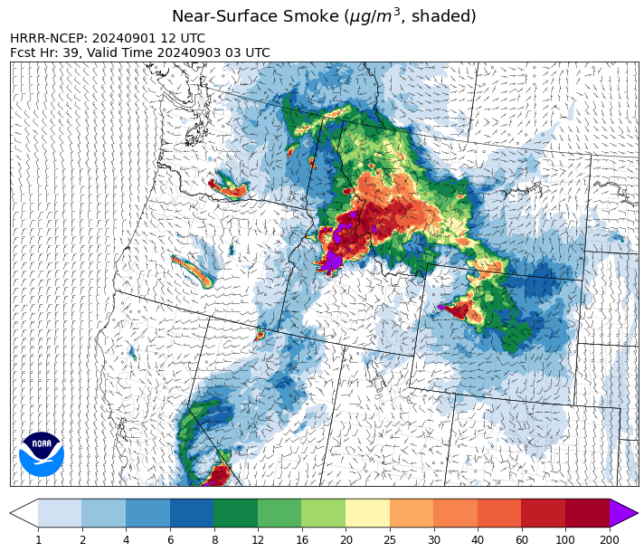
Source: HRRR Smoke
Conditions can change quickly as weather could stimulate active fires and the likelihood of new starts increases. Please keep track of concentrations at todaysair.mtdeq.us or the Fire and Smoke Map.
Current Wildfires
|
Incident |
State |
location |
acres |
containment |
|
Wapiti Fire - IDBOF |
Idaho |
2 miles southwest of Grandjean, ID |
97,753 |
0% |
|
Parks Fire - IDPAF |
Idaho |
NA |
3,850 |
NA |
|
Wolf Creek Fire - IDPAF |
Idaho |
11 Miles NW of Cascade, ID |
1,154 |
95% |
|
Burnt Creek Fire - IDPAF |
Idaho |
NA |
2,497 |
NA |
|
Farrow Fire - IDPAF |
Idaho |
NA |
852 |
NA |
|
Dollar Fire - IDBOF |
Idaho |
18 miles NE of Cascade, Idaho |
3,419 |
0% |
|
Boulder Fire - IDBOF |
Idaho |
9 Miles Southwest of Cascade, Idaho. |
2,393 |
57% |
|
Snag Fire - IDBOF |
Idaho |
9.5 miles East of Cascade, Idaho |
30,046 |
3% |
|
Goat Fire - IDBOF |
Idaho |
11 miles SE of Cascade, Idaho |
2,708 |
0% |
|
Middle Fork Complex Fire: Bulldog, Nellie, Anderson - IDBOF |
Idaho |
9 miles east of Garden Valley, ID |
54,902 |
13% |
|
Limepoint Fire - IDPAF |
Idaho |
8 miles NE of Oxbow Dam |
32,973 |
93% |
|
Surprise Fire - IDNCF |
Idaho |
Three and one-half miles NE of Hunter Peak, Fifteen miles NW of Darby, MT in the Selway-Bitterroot Wilderness |
40 |
NA |
|
Wye Fire - IDNCF |
Idaho |
East Moose creek Bridge to Elbow Bend impacted |
7,739 |
NA |
|
Cracker Jack Complex - IDNCF |
Idaho |
All four fires are located within half a mile of each other: two and a half miles east of Concord, ID, less than a quarter acre east from Square Lake and less than a quarter acre west from Fish Lake. |
1,345 |
NA |
|
Anchor Fire - IDNCF |
Idaho |
About half way between Hanover Mountain and Square Mountain in the Gospel Hump Wilderness |
400 |
NA |
|
2024 Flat - IDIDS |
Idaho |
One mile east of Pioneerville, Idaho |
3,734 |
61% |
|
Bulltrout Fire - IDBOF |
Idaho |
15 miles WNW OF Stanley, ID |
271 |
92% |
|
Monumental Fire - IDPAF |
Idaho |
NA |
11 |
NA |
|
Ace Butte Fire - IDNCF |
Idaho |
Approximately 30 miles Southeast of Grangeville, Idaho |
152 |
NA |
|
Robbin Fire - IDNCF |
Idaho |
Within Game Unit 12: located less than six and a half miles southwest of Powell Ranger Station and less than three and a half miles south of Wendover Campground |
NA |
NA |
|
Grave Butte Fire - IDNCF |
Idaho |
Within Game Unit 12: located ten miles west of Jerry Johnson Campground and about half a mile from National Forest Service Road #107 (Saddle Camp Road) |
10 |
NA |
|
Boulder Creek Fire - IDNCF |
Idaho |
Within Game Unit 12: located ten miles north of the Powell Ranger Station and 12 miles west of Lolo Hot Springs |
25 |
NA |
|
Bench Lake Fire - IDSTF |
Idaho |
8 miles south of Stanley, Idaho |
2,595 |
90% |
|
Shepp Fire - IDNCF |
Idaho |
Approximately 30 miles Southwest of Elk City, Idaho |
100 |
NA |
|
Oxbow Fire - IDPAF |
Idaho |
Near Oxbow dam in Hells Canyon |
6,000 |
NA |
|
Sharrott Creek Fire - MTBRF |
Montana |
Three miles west of Stevensville, Montana |
1,775 |
NA |
|
Railroad-Daly Fire - MTBRF |
Montana |
Railroad Creek/ Skalkaho Creek confluence, 26 miles SE of Hamilton |
160 |
0% |
|
McElwain Fire - MTMTS |
Montana |
10 miles west of Helmville, MT |
116 |
50% |
|
Ratio Mountain - MTBDF |
Montana |
15 miles northwest of Whitehall, MT. |
1,058 |
NA |
|
Johnson Fire - MTBRF |
Montana |
3 miles west of the Springer Memorial Community in the East Fork on the Bitterroot NF |
1,428 |
0% |
|
Remington Fire - MTGNF |
Montana |
14 miles NE of Leiter, WY, multiple counties in southeast Montana. |
196,368 |
81% |
|
Marsh Creek - MTHLF |
Montana |
12 Miles Southeast of Lincoln, MT |
20 |
0% |
|
Grouse - MTBDF |
Montana |
Ten miles southwest of Wise River, MT |
4,266 |
22% |
|
Big Hollow Fire - MTMTS |
Montana |
36 miles southwest of Dillon, MT |
3,435 |
90% |
|
Elkhorn Ridge - MTBRF |
Montana |
West Fork District |
2,482 |
0% |
|
Pentagon Fire - MTFNF |
Montana |
45 miles SE of Bigfork, MT |
62 |
0% |
|
Muir Creek Fire - MTGNP |
Montana |
20 miles southeast of West Glacier, MT and east of the Middle Fork of the Flathead River |
30 |
0% |
|
Diamond Complex - ORUPF |
Oregon |
18 miles southwest of Chemult, Oregon |
11,141 |
78% |
|
Homestead Complex - ORUPF |
Oregon |
Thirty miles northeast of Glide Oregon |
5,910 |
60% |
|
Sandstone Fire - ORMHF |
Oregon |
9 miles SW of Ripplebrook, OR, on the Mt. Hood National Forest |
702 |
75% |
|
Whisky Creek Fire - ORMHF |
Oregon |
East fork of Herman Creek, 6 miles SE of Cascade Locks, OR |
2,086 |
25% |
|
Middle Fork Fire - ORCLP |
Oregon |
Crater Lake National Park; Middle Fork area |
5,282 |
46% |
|
Cottage Grove - Lane 1 - OR77S |
Oregon |
Approximately 16 miles SE of Springfield, OR |
25,305 |
93% |
|
Red Fire - ORDEF |
Oregon |
Diamond Peak Wilderness, 16 miles west, north-west of Crescent Oregon. |
784 |
0% |
|
Willamette Complex Fires - South - ORWIF |
Oregon |
Willamette Complex South fires are 8 miles north and 8 to 22 miles S-SE of Oakridge. |
13,179 |
64% |
|
Crazy Creek - OROCF |
Oregon |
Crazy Creek:16 miles north of Paulina, OR |
86,968 |
93% |
|
North Willamette Complex - ORWIF |
Oregon |
Willamette National Forest |
4,583 |
NA |
|
Microwave Tower Fire - OR95S |
Oregon |
1 mile WSW of Mosier, OR |
1,313 |
95% |
|
Lone Rock Fire - ORPRD |
Oregon |
Lonerock stretching to west of HWY 207 and south to HWY 19 |
137,222 |
98% |
|
Dixon Fire - ORUPF |
Oregon |
Tiller, Oregon |
1,970 |
87% |
|
Battle Mountain Complex - OR97S |
Oregon |
West and south of Ukiah, OR |
183,026 |
94% |
|
Warner Peak Fire - ORSHR |
Oregon |
3 miles East of Plush, on the Hart Mountain Antelope Refuge |
65,866 |
85% |
|
Town Gulch - ORWWF |
Oregon |
Eagle Creek Rd Area, 24 Miles East of Baker City OR, 8 Miles N of Richland, OR |
18,220 |
89% |
|
Cliff Mountain - ORWWF |
Oregon |
25 Miles East of Joseph, Oregon |
1,108 |
75% |
|
Porcupine Fire - ORBUD |
Oregon |
Porcupine Reservoir |
6,491 |
95% |
|
Badland Complex 2024 - ORVAD |
Oregon |
Baker County, Oregon |
54,563 |
99% |
|
Durkee Fire - ORVAD |
Oregon |
1 mile west of Durkee, Oregon |
294,265 |
95% |
|
Cow Valley Fire - ORVAD |
Oregon |
West of Brogan and Northwest of Vale |
133,,490 |
99% |
|
Ruby Fire - WANCP |
Washington |
On Ruby Mountain in North Cascade National Park by Diablo and Ross Lake, 9 miles East of Newhalem |
959 |
0% |
|
Williams Mine Fire-GPNF - WAGPF |
Washington |
3.5 miles NNW of Trout Lake WA |
11904 |
31% |
|
Pincer Two Fire - WAMSF |
Washington |
Johannesburg Mountain. 1 Mile East of Mineral Park Campground |
211 |
0% |
|
Upper Ruby - WACOF |
Washington |
Ruby Creek Drainage - approximately 16 miles northwest of Cusick, WA |
280 |
94% |
|
Pioneer - WASES |
Washington |
Approximate start 10 miles southeast of Stehekin, WA |
38,735 |
23% |
|
Easy Fire - WAOWF |
Washington |
North Cascades Hwy 20 Corridor, 17 air miles west of Mazama, WA |
2,130 |
36% |
|
Retreat - WASES |
Washington |
14 miles WSE of Naches, WA |
45,601 |
85% |
|
Stranger Creek II - WACOA |
Washington |
NA |
66 |
90% |
|
Six Mile - WACOA |
Washington |
Two miles east of Nine Mile Hellgate Road, near the head of Cottonwood Creek |
113 |
90% |
|
Lodgepole - WAOWF |
Washington |
16 miles west of Cliffdell, WA |
35 |
6% |
|
Cougar Creek Fire - WASES |
Washington |
1 mile west of Hwy 129 and Grand Ronde river intersection |
24,091 |
80% |
|
Kachess Complex - WAOWF |
Washington |
12 miles west of Cle Elum drainage |
23 |
NA |
Source: Inciweb
Tags: Smoke Forecast 2024