
Smoke Forecast for Saturday, August 31, 2024 4:30 PM
Current Conditions
An Air Quality Alert is in effect for Beaverhead and Ravalli Counties until 4PM Sunday because of elevated particulate levels from wildfires smoke.
High pressure, dry fuels, and numerous active wildfires continue to spread smoke into parts of Western Montana.
There are numerous active fires burning in the Bitterroot Mountains of Idaho and Montana. These fires will continue to spread smoke into portions of Western Montana in the coming days. The Elkhorn Ridge fire has burned more than 3,120 acres and is 0% contained. It is burning along the Salmon River just a few miles west of the Montana border. Just west of Salmon, Idaho, the Burnt Creek fire expanded again on Wednesday. It has burned close to 2,500 acres and is 0% contained. The Wye fire is burning 30 miles west of Hamilton and has burned more than 7,000 acres. It is 0% contained.
On Saturday, there were four fires burning in Western Montana that exhibited active fire behavior. The Grouse fire burning just east of Wisdom has burned more than 4,000 acres and is 22% contained. The Johnson fire burning just east of Sula has burned 800 acres and is 0% contained. The Sharrott Creek fire just west of Stevensville has burned over 1,300 acres and is 0% contained. Lastly, the Ratio Mountain fire burning east of Butte has burned more than 700 acres and is 9% contained.
The Remington fire started in Wyoming last week. It is burning in mainly grassland and scrubland. The fire quickly expanded north into Montana over the weekend and has now burned nearly 200,000 acres. A crew of 196 has made considerable progress on the fire which is now 76% contained.
At 4:00 PM Saturday, Great Falls, Missoula, Butte, Bozeman, Dillon, West Yellowstone, and Broadus were enduring Moderate air quality. Hamilton was experiencing air that is considered Unhealthy for Sensitive Groups.
Saturday afternoon’s satellite shows areas of heavy smoke over Western Montana from wildfires burning across the region.
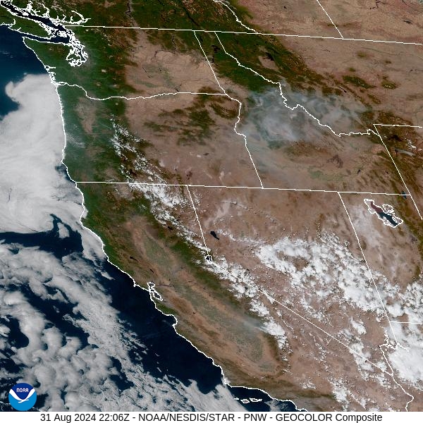
Source: NOAA
Forecast
Unseasonably warm temperatures, dry fuels, and high pressure have produced active fire behavior on numerous blazes in Idaho and Western Montana. The ridge will strengthen on Sunday, providing near record high temperatures. Smoke will continue to plague much of the Bitterroot and Big Hole Valleys, with the usual diurnal fluctuations in air quality anticipated. Smoke will pool and drain overnight into the valleys. As the inversion starts to lift around midday, expect gradual improvements in air quality as surface smoke mixes out. A light southwesterly flow will allow the smoke to gradually trickle northeast into Granite, Deer Lodge, Silver Bow, and Missoula Counties.
An area of low pressure will provide scattered showers and thunderstorms for the area by Monday. Gusty outflow winds from any thunderstorms could produce erratic fire behavior on existing wildfires. Gusts as high as 50 or 60 mph could accompany a few of the stronger storms. Slightly cooler air will follow the system on Tuesday with afternoon highs closer to average.
High pressure builds back over the Northern Rockies starting Wednesday. The combination of warm temperatures, low humidity, dry fuels, and gusty winds will lead to additional growth on wildfires across Montana and Idaho. Unfortunately, there is little to no precipitation in the forecast for the area this week. So, air quality will be an ongoing concern across the Treasure State with numerous wildfires burning around the region. Stay tuned!
By late Sunday, the HRRR smoke model shows heavy smoke moving into Southwest Montana, including the Bitterroot Valley.
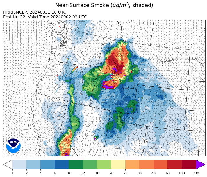
Source: HRRR Smoke
Conditions can change quickly as weather could stimulate active fires and the likelihood of new starts increases. Please keep track of concentrations at todaysair.mtdeq.us or the Fire and Smoke Map.
Current Wildfires
|
Incident |
State |
location |
acres |
containment |
|
Wapiti Fire - IDBOF |
Idaho |
2 miles southwest of Grandjean, ID |
94,685 |
0% |
|
Wolf Creek Fire - IDPAF |
Idaho |
11 Miles NW of Cascade, ID |
1154 |
95% |
|
Snag Fire - IDBOF |
Idaho |
9.5 miles East of Cascade, Idaho |
29,542 |
3% |
|
Boulder Fire - IDBOF |
Idaho |
9 Miles southwest of Cascade, Idaho. |
2,372 |
57% |
|
Dollar Fire - IDBOF |
Idaho |
18 miles NE of Cascade, Idaho |
3,271 |
0% |
|
Goat Fire - IDBOF |
Idaho |
11 miles SE of Cascade, Idaho |
2,708 |
0% |
|
Farrow Fire - IDPAF |
Idaho |
NA |
852 |
NA |
|
Parks Fire - IDPAF |
Idaho |
NA |
3,206 |
NA |
|
Burnt Creek Fire - IDPAF |
Idaho |
NA |
2,497 |
NA |
|
Limepoint Fire - IDPAF |
Idaho |
8 miles NE of Oxbow Dam |
32,735 |
93% |
|
Surprise Fire - IDNCF |
Idaho |
Three and one-half miles NE of Hunter Peak, Fifteen miles NW of Darby, MT in the Selway-Bitterroot Wilderness |
40 |
NA |
|
Wye Fire - IDNCF |
Idaho |
East Moose creek Bridge to Elbow Bend impacted |
7,739 |
NA |
|
Cracker Jack Complex - IDNCF |
Idaho |
All four fires are located within half a mile of each other: two and a half miles east of Concord, ID, less than a quarter acre east from Square Lake and less than a quarter acre west from Fish Lake. |
1,345 |
NA |
|
Anchor Fire - IDNCF |
Idaho |
About half way between Hanover Mountain and Square Mountain in the Gospel Hump Wilderness |
400 |
NA |
|
2024 Flat - IDIDS |
Idaho |
One mile east of Pioneerville, Idaho |
3,734 |
61% |
|
Bulltrout Fire - IDBOF |
Idaho |
15 miles WNW OF Stanley, ID |
271 |
92% |
|
Monumental Fire - IDPAF |
Idaho |
NA |
11 |
NA |
|
Sharrott Creek Fire - MTBRF |
Montana |
Three miles west of Stevensville, Montana |
1,458 |
NA |
|
Johnson Fire - MTBRF |
Montana |
3 miles west of the Springer Memorial Community in the East Fork on the Bitterroot NF |
1,428 |
0% |
|
Grouse - MTBDF |
Montana |
Ten miles southwest of Wise River, MT |
4,266 |
22% |
|
Big Hollow Fire - MTMTS |
Montana |
36 miles southwest of Dillon, MT |
3,435 |
90% |
|
Ratio Mountain - MTBDF |
Montana |
15 miles northwest of Whitehall, MT. |
750 |
NA |
|
Marsh Creek - MTHLF |
Montana |
12 Miles Southeast of Lincoln, MT |
4 |
0% |
|
Remington Fire - MTGNF |
Montana |
14 miles NE of Leiter, WY, multiple counties in southeast Montana. |
196,368 |
76% |
|
McElwain Fire - MTMTS |
Montana |
10 miles west of Helmville, MT |
116 |
25% |
|
Railroad-Daly Fire - MTBRF |
Montana |
Railroad Creek/ Skalkaho Creek confluence, 26 miles SE of Hamilton |
141 |
1% |
|
Elkhorn Ridge - MTBRF |
Montana |
West Fork District |
2,482 |
0% |
|
Middle Fork Fire - ORCLP |
Oregon |
Crater Lake National Park; Middle Fork area |
5,282 |
46% |
|
Diamond Complex - ORUPF |
Oregon |
18 miles southwest of Chemult, Oregon |
11,138 |
78% |
|
Red Fire - ORDEF |
Oregon |
Diamond Peak Wilderness, 16 miles west, north-west of Crescent Oregon. |
762 |
0% |
|
Whisky Creek Fire - ORMHF |
Oregon |
East fork of Herman Creek, 6 miles SE of Cascade Locks, OR |
2,085 |
24% |
|
Sandstone Fire - ORMHF |
Oregon |
9 miles SW of Ripplebrook, OR, on the Mt. Hood National Forest |
702 |
75% |
|
Willamette Complex Fires - South - ORWIF |
Oregon |
Willamette Complex South fires are 8 miles north and 8 to 22 miles S-SE of Oakridge. |
13,169 |
NA |
|
Crazy Creek - OROCF |
Oregon |
Crazy Creek:16 miles north of Paulina, OR |
86,968 |
93% |
|
North Willamette Complex - ORWIF |
Oregon |
Willamette National Forest |
4,525 |
NA |
|
Homestead Complex - ORUPF |
Oregon |
Thirty miles northeast of Glide Oregon |
5,910 |
60% |
|
Microwave Tower Fire - OR95S |
Oregon |
1 mile WSW of Mosier, OR |
1,313 |
95% |
|
Cottage Grove - Lane 1 - OR77S |
Oregon |
Approximately 16 miles SE of Springfield, OR |
25,267 |
93% |
|
Lone Rock Fire - ORPRD |
Oregon |
Lonerock stretching to west of HWY 207 and south to HWY 19 |
137,222 |
98% |
|
Pincer Two Fire - WAMSF |
Washington |
Johannesburg Mountain. 1 Mile East of Mineral Park Campground |
211 |
0% |
|
Williams Mine Fire-GPNF - WAGPF |
Washington |
3.5 miles NNW of Trout Lake WA |
11,821 |
31% |
|
Ruby Fire - WANCP |
Washington |
On Ruby Mountain in North Cascade National Park by Diablo and Ross Lake, 9 miles East of Newhalem |
959 |
0% |
|
Upper Ruby - WACOF |
Washington |
Ruby Creek Drainage - approximately 16 miles northwest of Cusick, WA |
280 |
94% |
|
Pioneer - WASES |
Washington |
Approximate start 10 miles southeast of Stehekin, WA |
38,735 |
23% |
|
Easy Fire - WAOWF |
Washington |
North Cascades Hwy 20 Corridor, 17 air miles west of Mazama, WA |
2,130 |
36% |
|
Retreat - WASES |
Washington |
14 miles WSE of Naches, WA |
45,601 |
85% |
|
Stranger Creek II - WACOA |
Washington |
NA |
66 |
90% |
|
Six Mile - WACOA |
Washington |
Two miles east of Nine Mile Hellgate Road, near the head of Cottonwood Creek |
113 |
90% |
Source: Inciweb
Tags: Smoke Forecast 2024