
Smoke Forecast for Friday, August 30, 2024 9:30 AM
Current Conditions
High pressure builds across the Northern Rockies on Friday and into the weekend. It will allow smoke from regional wildfires to return to parts of the Treasure State.
There are numerous active fires burning in the Bitterroot Mountains of Idaho and Montana. These fires will continue to spread smoke into portions of Western Montana in the coming days. The Elkhorn Ridge fire has burned more than 3,120 acres and is 0% contained. It is burning along the Salmon River just a few miles west of the Montana border. Just west of Salmon, Idaho, the Burnt Creek fire expanded again on Wednesday. It has burned close to 2,500 acres and is 0% contained. The Wye fire is burning 30 miles west of Hamilton and has burned more than 7,000 acres. It is 0% contained.
On Thursday, there were four fires burning in Western Montana that exhibited active fire behavior. The Grouse fire burning just east of Wisdom has burned more than 4,000 acres and is 22% contained. The Johnson fire burning just east of Sula has burned 400 acres and is 0% contained. The Sharrott Creek fire just west of Stevensville has burned over 1,300 acres and is 0% contained. Lastly, the Ratio Mountain fire burning east of Butte has burned more than 400 acres and is 9% contained.
The Remington fire started in Wyoming last week. It is burning in mainly grassland and scrubland. The fire quickly expanded north into Montana over the weekend and has now burned nearly 200,000 acres. A crew of 196 has made considerable progress on the fire which is now 66% contained.
At 9:00 AM Friday, Hamilton was enduring Moderate air quality.
Friday morning’s satellite shows little to no smoke over Western Montana, with heavy smoke across much of central and southern Idaho.
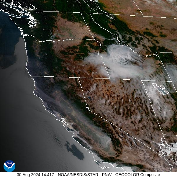
Source: NOAA
Forecast
High pressure will be the main story throughout the Labor Day weekend. It will provide mostly dry conditions for the Northern Rockies. Temperatures will gradually moderate, with highs into the 80s and 90s, well above seasonal averages. There are several active wildfires now burning in Southwest Montana. Due to the combination of warm temperatures, low humidity, and limited precipitation, these fires will likely expand in the coming days. Air quality is expected to deteriorate, particularly over Southwest Montana, including the Bitterroot Valley.
A southwesterly flow will return by late Monday and Tuesday. This pattern will bring smoke from giant wildfires burning in the mountains of Central Idaho into parts of Montana. A weak area of low pressure will also kick off a few showers and thunderstorms and provide slightly cooler temperatures.
Unseasonably warm air returns by midweek thanks to upper-level ridging. This will provide another round of highs well into the 80s and 90s. Expect active fire weather and increased smoke production on wildfires under this pattern, with the usual diurnal fluctuations in surface smoke. Unfortunately, there is little to no precipitation expected for Montana over the next 7-days, so air quality will become an issue, particularly for communities adjacent to wildfires. Stay tuned!
By midday Saturday, the HRRR smoke model shows heavy smoke moving into Southwest Montana, including the Bitterroot Valley.
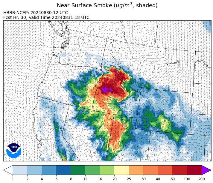
Source: HRRR Smoke
Conditions can change quickly as weather could stimulate active fires and the likelihood of new starts increases. Please keep track of concentrations at todaysair.mtdeq.us or the Fire and Smoke Map.
Current Wildfires
|
Incident |
State |
location |
acres |
containment |
|
Middle Fork Complex Fire: Bulldog, Nellie, Anderson - IDBOF |
Idaho |
9 miles east of Garden Valley, ID |
53,689 |
6% |
|
Wapiti Fire - IDBOF |
Idaho |
2 miles southwest of Grandjean, ID |
92,141 |
0% |
|
Limepoint Fire - IDPAF |
Idaho |
8 miles NE of Oxbow Dam |
32,735 |
93% |
|
Boulder Fire - IDBOF |
Idaho |
9 Miles southwest of Cascade, Idaho. |
2,372 |
57% |
|
Snag Fire - IDBOF |
Idaho |
9.5 miles East of Cascade, Idaho |
28,454 |
3% |
|
Goat Fire - IDBOF |
Idaho |
11 miles SE of Cascade, Idaho |
2,580 |
0% |
|
Dollar Fire - IDBOF |
Idaho |
18 miles NE of Cascade, Idaho |
3,442 |
0% |
|
Wolf Creek Fire - IDPAF |
Idaho |
11 Miles NW of Cascade, ID |
1,154 |
95% |
|
Anchor Fire - IDNCF |
Idaho |
About half way between Hanover Mountain and Square Mountain in the Gospel Hump Wilderness |
400 |
NA |
|
Wye Fire - IDNCF |
Idaho |
East Moose creek Bridge to Elbow Bend impacted |
6,763 |
NA |
|
Cracker Jack Complex - IDNCF |
Idaho |
All four fires are located within half a mile of each other: two and a half miles east of Concord, ID, less than a quarter acre east from Square Lake and less than a quarter acre west from Fish Lake. |
1,345 |
NA |
|
2024 Flat - IDIDS |
Idaho |
One mile east of Pioneerville, Idaho |
3,734 |
61% |
|
Farrow Fire - IDPAF |
Idaho |
NA |
852 |
NA |
|
Burnt Creek Fire - IDPAF |
Idaho |
NA |
600 |
NA |
|
Parks Fire - IDPAF |
Idaho |
NA |
2,043 |
NA |
|
Surprise Fire - IDNCF |
Idaho |
Three and one-half miles NE of Hunter Peak, Fifteen miles NW of Darby, MT in the Selway-Bitterroot Wilderness |
20 |
NA |
|
Bulltrout Fire - IDBOF |
Idaho |
15 miles WNW OF Stanley, ID |
271 |
92% |
|
Monumental Fire - IDPAF |
Idaho |
NA |
11 |
NA |
|
Ace Butte Fire - IDNCF |
Idaho |
Approximately 30 miles Southeast of Grangeville, Idaho |
152 |
NA |
|
Sharrott Creek Fire - MTBRF |
Montana |
Three miles west of Stevensville, Montana |
1367 |
NA |
|
Remington Fire - MTGNF |
Montana |
14 miles NE of Leiter, WY, multiple counties in southeast Montana. |
196,238 |
66% |
|
Johnson Fire - MTBRF |
Montana |
3 miles west of the Springer Memorial Community in the East Fork on the Bitterroot NF |
861 |
0% |
|
Railroad-Daly Fire - MTBRF |
Montana |
Railroad Creek/ Skalkaho Creek confluence, 26 miles SE of Hamilton |
141 |
1% |
|
Marsh Creek - MTHLF |
Montana |
12 Miles Southeast of Lincoln, MT |
4 |
0% |
|
McElwain Fire - MTMTS |
Montana |
10 miles west of Helmville, MT |
176 |
25% |
|
Big Hollow Fire - MTMTS |
Montana |
36 miles southwest of Dillon, MT |
3,435 |
80% |
|
Ratio Mountain - MTBDF |
Montana |
15 miles northwest of Whitehall, MT. |
451 |
NA |
|
Grouse - MTBDF |
Montana |
Ten miles southwest of Wise River, MT |
4,200 |
22% |
|
Elkhorn Ridge - MTBRF |
Montana |
West Fork District |
2,482 |
0% |
|
North Willamette Complex - ORWIF |
Oregon |
Willamette National Forest |
4,487 |
NA |
|
Middle Fork Fire - ORCLP |
Oregon |
Crater Lake National Park; Middle Fork area |
5,281 |
42% |
|
Diamond Complex - ORUPF |
Oregon |
18 miles southwest of Chemult, Oregon |
11,152 |
77% |
|
Cottage Grove - Lane 1 - OR77S |
Oregon |
Approximately 16 miles SE of Springfield, OR |
25,267 |
93% |
|
Willamette Complex Fires - South - ORWIF |
Oregon |
Willamette Complex South fires are 8 miles north and 8 to 22 miles S-SE of Oakridge. |
13,091 |
NA |
|
Crazy Creek - OROCF |
Oregon |
Crazy Creek:16 miles north of Paulina, OR |
86,968 |
93% |
|
Sandstone Fire - ORMHF |
Oregon |
9 miles SW of Ripplebrook, OR, on the Mt. Hood National Forest |
702 |
75% |
|
Whisky Creek Fire - ORMHF |
Oregon |
East fork of Herman Creek, 6 miles SE of Cascade Locks, OR |
2,084 |
24% |
|
Homestead Complex - ORUPF |
Oregon |
Thirty miles northeast of Glide Oregon |
5,910 |
60% |
|
Red Fire - ORDEF |
Oregon |
Diamond Peak Wilderness, 16 miles west, north-west of Crescent Oregon. |
755 |
0% |
|
Lone Rock Fire - ORPRD |
Oregon |
Lonerock stretching to west of HWY 207 and south to HWY 19 |
137,222 |
98% |
|
Williams Mine Fire-GPNF - WAGPF |
Washington |
3.5 miles NNW of Trout Lake WA |
11,798 |
31% |
|
Ruby Fire - WANCP |
Washington |
On Ruby Mountain in North Cascade National Park by Diablo and Ross Lake, 9 miles East of Newhalem |
959 |
0% |
|
Upper Ruby - WACOF |
Washington |
Ruby Creek Drainage - approximately 16 miles northwest of Cusick, WA |
280 |
76% |
|
Pincer Two Fire - WAMSF |
Washington |
Johannesburg Mountain. 1 Mile East of Mineral Park Campground |
189 |
0% |
|
Pioneer - WASES |
Washington |
Approximate start 10 miles southeast of Stehekin, WA |
38,735 |
23% |
|
Easy Fire - WAOWF |
Washington |
North Cascades Hwy 20 Corridor, 17 air miles west of Mazama, WA |
2,130 |
36% |
|
Retreat - WASES |
Washington |
14 miles WSE of Naches, WA |
45,601 |
85% |
|
Stranger Creek II - WACOA |
Washington |
NA |
66 |
90% |
Source: Inciweb
Tags: Smoke Forecast 2024