
Smoke Forecast for Thursday, August 29, 2024 9:30 AM
Current Conditions
Low pressure exits the region on Thursday. Warmer air will quickly build across the region, leading to more active fire behavior and increased smoke production.
There are numerous active fires burning along the west side of the Bitterroot Mountains in Idaho. These fires will continue to spread smoke into portions of Western Montana in the coming days. The Elkhorn Ridge fire has burned more than 2,500 acres and is 0% contained. It is burning along the Salmon River just a few miles west of the Montana border. Just west of Salmon, Idaho, the Burnt Creek fire expanded again on Wednesday. It has burned close to 2,500 acres and is 0% contained.
The Remington fire started in Wyoming last week. It is burning in mainly grassland and scrubland. The fire quickly expanded north into Montana over the weekend and has now burned nearly 200,000 acres. A crew of 228 has made considerable progress on the fire which is now 61% contained.
At 9:00 AM Thursday, Great Falls, Hamilton, and Libby were enduring Moderate air quality.
Thursday morning’s satellite shows light smoke over Southwest Montana, with heavy smoke from Idaho wildfires staying south of the Treasure State.
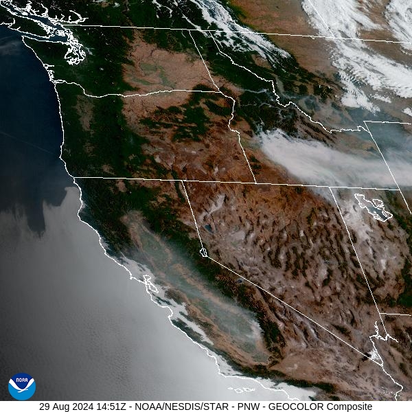
Source: NOAA
Forecast
Low pressure pulls away from the Treasure State on Thursday. Drier and warmer air will quickly move into the region behind the departing low. There are numerous active fires burning across the higher terrain of Central Idaho and fire activity should increase in the coming days. In the upper levels, the flow remains out of the northwest on Thursday keeping the bulk of the smoke from these fires out of Montana.
High pressure builds over the region this weekend. It will bring much warmer temperatures back to the Treasure State, with highs back in the upper 80s and 90s for most of the valleys. The flow gradually turns around to the west and southwest. This will pump smoke from fires burning across Idaho back in Montana. Expect air quality to deteriorate under this pattern with the usual diurnal fluctuations in surface smoke.
By early next week, a southwesterly flow will persist across the Northern Rockies. It will bring monsoonal moisture back to the Treasure State with daily chances for afternoon showers and storms. Widespread rain isn’t likely, so fire behavior will remain active on existing fires due to warm temperatures and gusty winds. Unfortunately, the southwesterly flow will continue to bring smoke from fires burning upstream in Idaho into Montana. Stay tuned!
By late Friday, the HRRR smoke model shows smoke moving into parts of Southwest Montana from fires burning across Central Idaho.
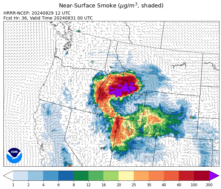
Source: HRRR Smoke
Conditions can change quickly as weather could stimulate active fires and the likelihood of new starts increases. Please keep track of concentrations at todaysair.mtdeq.us or the Fire and Smoke Map.
Current Wildfires
|
Incident |
State |
location |
acres |
containment |
|
Middle Fork Complex Fire: Bulldog, Nellie, Anderson - IDBOF |
Idaho |
9 miles east of Garden Valley, ID |
52,974 |
5% |
|
Wapiti Fire - IDBOF |
Idaho |
2 miles southwest of Grandjean, ID |
89,714 |
0% |
|
Limepoint Fire - IDPAF |
Idaho |
8 miles NE of Oxbow Dam |
32,636 |
88% |
|
Snag Fire - IDBOF |
Idaho |
9.5 miles East of Cascade, Idaho |
27,458 |
3% |
|
Dollar Fire - IDBOF |
Idaho |
18 miles NE of Cascade, Idaho |
2,937 |
0% |
|
Goat Fire - IDBOF |
Idaho |
11 miles SE of Cascade, Idaho |
2,427 |
0% |
|
Boulder Fire - IDBOF |
Idaho |
9 Miles southwest of Cascade, Idaho. |
2,396 |
57% |
|
Anchor Fire - IDNCF |
Idaho |
About half way between Hanover Mountain and Square Mountain in the Gospel Hump Wilderness |
400 |
NA |
|
Wolf Creek Fire - IDPAF |
Idaho |
11 Miles NW of Cascade, ID |
1,154 |
95% |
|
Wye Fire - IDNCF |
Idaho |
East Moose creek Bridge to Elbow Bend impacted |
6,763 |
NA |
|
Cracker Jack Complex - IDNCF |
Idaho |
All four fires are located within half a mile of each other: two and a half miles east of Concord, ID, less than a quarter acre east from Square Lake and less than a quarter acre west from Fish Lake. |
1,345 |
NA |
|
2024 Flat - IDIDS |
Idaho |
One mile east of Pioneerville, Idaho |
3,734 |
61% |
|
Farrow Fire - IDPAF |
Idaho |
NA |
852 |
NA |
|
Burnt Creek Fire - IDPAF |
Idaho |
NA |
600 |
NA |
|
Parks Fire - IDPAF |
Idaho |
NA |
2,043 |
NA |
|
Surprise Fire - IDNCF |
Idaho |
Three and one-half miles NE of Hunter Peak, Fifteen miles NW of Darby, MT in the Selway-Bitterroot Wilderness |
20 |
NA |
|
Bulltrout Fire - IDBOF |
Idaho |
15 miles WNW OF Stanley, ID |
271 |
92% |
|
Monumental Fire - IDPAF |
Idaho |
NA |
11 |
NA |
|
Ace Butte Fire - IDNCF |
Idaho |
Approximately 30 miles Southeast of Grangeville, Idaho |
152 |
NA |
|
Robbin Fire - IDNCF |
Idaho |
Within Game Unit 12: located less than six and a half miles southwest of Powell Ranger Station and less than three and a half miles south of Wendover Campground |
NA |
NA |
|
Grave Butte Fire - IDNCF |
Idaho |
Within Game Unit 12: located ten miles west of Jerry Johnson Campground and about half a mile from National Forest Service Road #107 (Saddle Camp Road) |
10 |
NA |
|
Boulder Creek Fire - IDNCF |
Idaho |
Within Game Unit 12: located ten miles north of the Powell Ranger Station and 12 miles west of Lolo Hot Springs |
25 |
NA |
|
Ratio Mountain - MTBDF |
Montana |
15 miles northwest of Whitehall, MT. |
451 |
NA |
|
Sharrott Creek Fire - MTBRF |
Montana |
Three miles west of Stevensville, Montana |
1,130 |
NA |
|
McElwain Fire - MTMTS |
Montana |
10 miles west of Helmville, MT |
176 |
5% |
|
Marsh Creek - MTHLF |
Montana |
12 Miles Southeast of Lincoln, MT |
4 |
0% |
|
Johnson Fire - MTBRF |
Montana |
3 miles west of the Springer Memorial Community in the East Fork on the Bitterroot NF |
400 |
0% |
|
Big Hollow Fire - MTMTS |
Montana |
36 miles southwest of Dillon, MT |
3,415 |
40% |
|
Remington Fire - MTGNF |
Montana |
14 miles NE of Leiter, WY, multiple counties in southeast Montana. |
196,459 |
50% |
|
Grouse - MTBDF |
Montana |
Ten miles southwest of Wise River, MT |
4,200 |
22% |
|
Railroad-Daly Fire - MTBRF |
Montana |
Railroad Creek/ Skalkaho Creek confluence, 26 miles SE of Hamilton |
98 |
1% |
|
Elkhorn Ridge - MTBRF |
Montana |
West Fork District |
2,482 |
0% |
|
Willamette Complex Fires - South - ORWIF |
Oregon |
Willamette Complex South fires are 8 miles north and 8 to 22 miles S-SE of Oakridge. |
13,082 |
NA |
|
Middle Fork Fire - ORCLP |
Oregon |
Crater Lake National Park; Middle Fork area |
5,280 |
37% |
|
Cottage Grove - Lane 1 - OR77S |
Oregon |
Approximately 16 miles SE of Springfield, OR |
25,267 |
93% |
|
Sandstone Fire - ORMHF |
Oregon |
9 miles SW of Ripplebrook, OR, on the Mt. Hood National Forest |
702 |
74% |
|
Whisky Creek Fire - ORMHF |
Oregon |
East fork of Herman Creek, 6 miles SE of Cascade Locks, OR |
2,084 |
24% |
|
North Willamette Complex - ORWIF |
Oregon |
Willamette National Forest |
4,462 |
NA |
|
Diamond Complex - ORUPF |
Oregon |
18 miles southwest of Chemult, Oregon |
11,152 |
76% |
|
Homestead Complex - ORUPF |
Oregon |
Thirty miles northeast of Glide Oregon |
5,911 |
60% |
|
Crazy Creek - OROCF |
Oregon |
Crazy Creek:16 miles north of Paulina, OR |
86,968 |
93% |
|
Red Fire - ORDEF |
Oregon |
Diamond Peak Wilderness, 16 miles west, north-west of Crescent Oregon. |
755 |
0% |
|
Lone Rock Fire - ORPRD |
Oregon |
Lonerock stretching to west of HWY 207 and south to HWY 19 |
137,222 |
98% |
|
Ruby Fire - WANCP |
Washington |
On Ruby Mountain in North Cascade National Park by Diablo and Ross Lake, 9 miles East of Newhalem |
959 |
0% |
|
Williams Mine Fire-GPNF - WAGPF |
Washington |
3.5 miles NNW of Trout Lake WA |
11,778 |
31% |
|
Upper Ruby - WACOF |
Washington |
Ruby Creek Drainage - approximately 16 miles northwest of Cusick, WA |
280 |
53% |
|
Pioneer - WASES |
Washington |
Approximate start 10 miles southeast of Stehekin, WA |
38,735 |
23% |
|
Pincer Two Fire - WAMSF |
Washington |
Johannesburg Mountain. 1 Mile East of Mineral Park Campground |
189 |
0% |
|
Easy Fire - WAOWF |
Washington |
North Cascades Hwy 20 Corridor, 17 air miles west of Mazama, WA |
2,130 |
36% |
|
Retreat - WASES |
Washington |
14 miles WSE of Naches, WA |
45,601 |
85% |
|
Stranger Creek II - WACOA |
Washington |
NA |
66 |
90% |
|
Six Mile - WACOA |
Washington |
Two miles east of Nine Mile Hellgate Road, near the head of Cottonwood Creek |
113 |
90% |
Source: Inciweb
Tags: Smoke Forecast 2024