
Smoke Forecast for Wednesday, August 28 2024 9:30 AM
Current Conditions
A strong cool front swept across the state on Tuesday. It is providing much cooler air and temporarily helping to reduce smoke production on regional wildfires.
The Wye fire burning about 30 miles west of Hamilton continues to generate smoke in the region. It has burned more than 6,700 acres and is 0% contained. The Sharrott Creek fire is burning just west of Stevensville and has burned more than 1,100 acres and is 0% contained. These fires received some rain on Tuesday and fire behavior will be moderated as a result.
The Remington fire started in Wyoming last week. It is burning in mainly grassland and scrubland. The fire quickly expanded north into Montana over the weekend and has now burned nearly 200,000 acres. Fire crews made a lot of progress over the last 24 hours and the fire is now 50% contained.
At 9:00 AM Wednesday, Great Falls, West Yellowstone, and Bozeman were enduring Moderate air quality.
Wednesday morning’s satellite shows a strong cool front marching across the state with lingering smoke across Central Idaho.
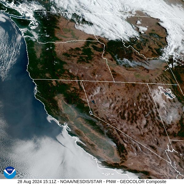
Source: NOAA
Forecast
A cold front swept across the region on Tuesday. It provided some beneficial rain on many regional wildfires. Expect at least a temporary reduction in smoke production and moderated fire behavior because of the precipitation and cooler air. Light rain and even some snow is possible above 5,000 feet through Wednesday evening.
Dry and breezy conditions are anticipated for Thursday across the Northern Rockies. As a result, expect fire behavior and smoke production to ramp up. The flow will be out of the west and northwest, so wildfires smoke from Central Idaho will impact the western half of the state.
Starting Friday, a ridge of high pressure builds across the area. Expect the usual diurnal fluctuations in smoke with this pattern. Overnight, smoke will pool and drain into the valleys adjacent to the wildfires, leading to deteriorating air quality. Once the inversion breaks by late morning or midday, better mixing should help scour out the valley smoke, leading to better air quality. Temperatures will gradually moderate under this pattern, with afternoon highs in the 90s for many of the valleys by the holiday weekend.
By Wednesday night, the HRRR smoke model shows smoke moving into parts of Southwest Montana from regional wildfires.
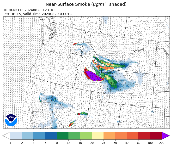
Source: HRRR Smoke
Conditions can change quickly as weather could stimulate active fires and the likelihood of new starts increases. Please keep track of concentrations at todaysair.mtdeq.us or the Fire and Smoke Map.
Current Wildfires
|
Incident |
State |
location |
acres |
containment |
|
Middle Fork Complex Fire: Bulldog, Nellie, Anderson - IDBOF |
Idaho |
9 miles east of Garden Valley, ID |
47,978 |
5% |
|
Wapiti Fire - IDBOF |
Idaho |
2 miles southwest of Grandjean, ID |
79,745 |
0% |
|
Limepoint Fire - IDPAF |
Idaho |
8 miles NE of Oxbow Dam |
32,636 |
88% |
|
Boulder Fire - IDBOF |
Idaho |
9 Miles southwest of Cascade, Idaho. |
2,396 |
57% |
|
Goat Fire - IDBOF |
Idaho |
11 miles SE of Cascade, Idaho |
2,274 |
0% |
|
Wolf Creek Fire - IDPAF |
Idaho |
11 Miles NW of Cascade, ID |
1,154 |
95% |
|
Snag Fire - IDBOF |
Idaho |
9.5 miles East of Cascade, Idaho |
27,458 |
3% |
|
Dollar Fire - IDBOF |
Idaho |
18 miles NE of Cascade, Idaho |
2,937 |
0% |
|
2024 Flat - IDIDS |
Idaho |
One mile east of Pioneerville, Idaho |
3,734 |
61% |
|
Farrow Fire - IDPAF |
Idaho |
NA |
852 |
NA |
|
Burnt Creek Fire - IDPAF |
Idaho |
NA |
600 |
NA |
|
Parks Fire - IDPAF |
Idaho |
NA |
2,043 |
NA |
|
Cracker Jack Complex - IDNCF |
Idaho |
All four fires are located within half a mile of each other: two and a half miles east of Concord, ID, less than a quarter acre east from Square Lake and less than a quarter acre west from Fish Lake. |
702 |
NA |
|
Surprise Fire - IDNCF |
Idaho |
Three and one-half miles NE of Hunter Peak, Fifteen miles NW of Darby, MT in the Selway-Bitterroot Wilderness |
20 |
NA |
|
Bulltrout Fire - IDBOF |
Idaho |
15 miles WNW OF Stanley, ID |
271 |
92% |
|
Wye Fire - IDNCF |
Idaho |
Approximately four and a half miles northwest of Freeman Peak and seven miles northeast of the Moose Creek Airstrip |
5,815 |
NA |
|
Monumental Fire - IDPAF |
Idaho |
NA |
11 |
NA |
|
Anchor Fire - IDNCF |
Idaho |
About half way between Hanover Mountain and Square Mountain in the Gospel Hump Wilderness |
135 |
NA |
|
Ace Butte Fire - IDNCF |
Idaho |
Approximately 30 miles Southeast of Grangeville, Idaho |
152 |
NA |
|
Robbin Fire - IDNCF |
Idaho |
Within Game Unit 12: located less than six and a half miles southwest of Powell Ranger Station and less than three and a half miles south of Wendover Campground |
NA |
NA |
|
Grave Butte Fire - IDNCF |
Idaho |
Within Game Unit 12: located ten miles west of Jerry Johnson Campground and about half a mile from National Forest Service Road #107 (Saddle Camp Road) |
10 |
NA |
|
Boulder Creek Fire - IDNCF |
Idaho |
Within Game Unit 12: located ten miles north of the Powell Ranger Station and 12 miles west of Lolo Hot Springs |
25 |
NA |
|
Bench Lake Fire - IDSTF |
Idaho |
8 miles south of Stanley, Idaho |
2,595 |
90% |
|
Remington Fire - MTGNF |
Montana |
14 miles NE of Leiter, WY, multiple counties in southeast Montana. |
196,459 |
50% |
|
Sharrott Creek Fire - MTBRF |
Montana |
Three miles west of Stevensville, Montana |
1,130 |
0% |
|
Grouse - MTBDF |
Montana |
Ten miles southwest of Wise River, MT |
4,200 |
22% |
|
McElwain Fire - MTMTS |
Montana |
10 miles west of Helmville, MT |
176 |
5% |
|
Ratio Mountain - MTBDF |
Montana |
15 miles northwest of Whitehall, MT. |
451 |
NA |
|
Big Hollow Fire - MTMTS |
Montana |
36 miles southwest of Dillon, MT |
3,415 |
40% |
|
Railroad-Daly Fire - MTBRF |
Montana |
Railroad Creek/ Skalkaho Creek confluence, 26 miles SE of Hamilton |
98 |
1% |
|
Johnson Fire - MTBRF |
Montana |
3 miles west of the Springer Memorial Community in the East Fork on the Bitterroot NF |
370 |
0% |
|
Elkhorn Ridge - MTBRF |
Montana |
West Fork District |
2,482 |
0% |
|
North Willamette Complex - ORWIF |
Oregon |
Willamette National Forest |
4,462 |
NA |
|
Middle Fork Fire - ORCLP |
Oregon |
Crater Lake National Park; Middle Fork area |
5,280 |
27% |
|
Diamond Complex - ORUPF |
Oregon |
18 miles southwest of Chemult, Oregon |
11,152 |
73% |
|
Whisky Creek Fire - ORMHF |
Oregon |
East fork of Herman Creek, 6 miles SE of Cascade Locks, OR |
2,075 |
24% |
|
Sandstone Fire - ORMHF |
Oregon |
9 miles SW of Ripplebrook, OR, on the Mt. Hood National Forest |
702 |
59% |
|
Red Fire - ORDEF |
Oregon |
Diamond Peak Wilderness, 16 miles west, north-west of Crescent Oregon. |
755 |
0% |
|
Homestead Complex - ORUPF |
Oregon |
Thirty miles northeast of Glide Oregon |
5,909 |
50% |
|
Lone Rock Fire - ORPRD |
Oregon |
Lonerock stretching to west of HWY 207 and south to HWY 19 |
137,222 |
98% |
|
Crazy Creek - OROCF |
Oregon |
Crazy Creek:16 miles north of Paulina, OR |
86,968 |
93% |
|
Cottage Grove - Lane 1 - OR77S |
Oregon |
Approximately 16 miles SE of Springfield, OR |
25,265 |
90% |
|
Dixon Fire - ORUPF |
Oregon |
Tiller, Oregon |
1,970 |
87% |
|
Pioneer - WASES |
Washington |
Approximate start 10 miles southeast of Stehekin, WA |
38,735 |
23% |
|
Ruby Fire - WANCP |
Washington |
On Ruby Mountain in North Cascade National Park by Diablo and Ross Lake, 9 miles East of Newhalem |
959 |
0% |
|
Williams Mine Fire-GPNF - WAGPF |
Washington |
3.5 miles NNW of Trout Lake WA |
11,778 |
31% |
|
Upper Ruby - WACOF |
Washington |
Ruby Creek Drainage - approximately 16 miles northwest of Cusick, WA |
280 |
39% |
|
2620 Road Fire - WAOLC |
Washington |
The fire is located 5 miles West of Brinnon Washington. |
398 |
93% |
|
Pincer Two Fire - WAMSF |
Washington |
Johannesburg Mountain. 1 Mile East of Mineral Park Campground |
189 |
0% |
|
Easy Fire - WAOWF |
Washington |
North Cascades Hwy 20 Corridor, 17 air miles west of Mazama, WA |
2,130 |
36% |
|
Six Mile - WACOA |
Washington |
Two miles east of Nine Mile Hellgate Road, near the head of Cottonwood Creek |
113 |
90% |
|
Stranger Creek II - WACOA |
Washington |
NA |
66 |
90% |
|
Clearwater - WYSHF |
Wyoming |
11 Miles West of Wapiti, Wyoming |
1,966 |
75% |
|
House Draw Fire - WYHPD |
Wyoming |
9 Mile SE of Buffalo |
174,683 |
94% |
|
Fish Creek Fire - WYBTF |
Wyoming |
Approximately 7 miles southwest of Togwotee Pass |
11,397 |
NA |
Source: Inciweb
Tags: Smoke Forecast 2024