
Smoke Forecast for Monday, August 26, 2024 10:00 AM
Current Conditions
There are still numerous active wildfires burning in the mountains of Central Idaho. These fires are responsible for the smoke across much of Montana to start the week. The Snag fire grew considerably over the weekend. The fire is burning just south of McCall, Idaho and has already burned over 25,000 acres. The Nellie and Wapiti fires continue to produce a lot of smoke over the Northern Rockies as well. The Nellie fire has burned around 38,000 acres and is 5% contained. The Wapiti fire has burned around 68,000 acres and is 0% contained.
The two most important wildfires in Montana, in terms of resources being used to fight them, are the Sharrott Creek and Ratio Mountain fires. The Sharrott Creek blaze is burning just west of Stevensville, Montana in the Bitterroot Mountains. It has grown to over 1,000 acres with 0% containment. The Ratio Mountain fire is burning east of Butte, Montana has burned almost 500 acres and is 9% contained.
The Remington fire started in Wyoming last week. It is burning in mainly grassland and scrubland. The fire quickly expanded north into Montana over the weekend and has now burned nearly 200,000 acres.
At 9:00 AM Monday, Billings and Broadus were enduring Moderate air quality.
Monday morning’s satellite shows some light smoke across Montana, much of which is aloft, from fires burning in Central Idaho.
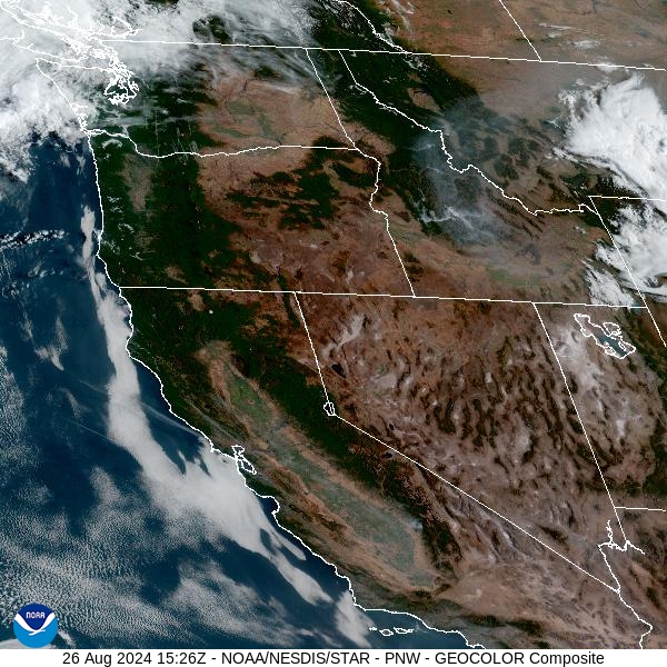
Source: NOAA
Forecast
A light westerly flow will set up over Montana to start the week. It will spread some smoke from wildfires burning in Idaho into the region. There are still numerous large, active wildfires burning across the mountains of Central Idaho. These fires will be a concern for Montana’s air quality for the foreseeable future.
A cold front will push across the area by late Tuesday. A westerly flow will ramp up as the day goes on, with wind gusts over 40 miles per hour possible. This will generate more active fire behavior on existing blazes and will lead to an increase in smoke production. Unfortunately, the front will be dry so the biggest impact will be from wind and cooler air. In fact, the coolest air of the season will follow the front and patchy frost is possible by Thursday morning.
High pressure builds over the Northern Rockies by the end of the week and into the weekend. The warmer air, lower humidity, and gusty winds should lead to an increase in fire activity. The southerly and southwesterly flow will bring additional smoke from the fire burning in Central Idaho into the Treasure State. Stay tuned!
By midday Tuesday, the HRRR smoke model shows smoke moving into Montana from wildfires burning in Idaho and Wyoming.
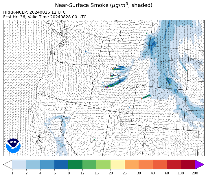
Source: HRRR Smoke
Conditions can change quickly as weather could stimulate active fires and the likelihood of new starts increases. Please keep track of concentrations at todaysair.mtdeq.us or the Fire and Smoke Map.
Current Wildfires
|
Incident |
State |
location |
acres |
containment |
|
Middle Fork Complex Fire: Bulldog, Nellie, Anderson - IDBOF |
Idaho |
9 miles east of Garden Valley, ID |
46,994 |
5% |
|
2024 Flat - IDIDS |
Idaho |
One mile east of Pioneerville, Idaho |
3,734 |
61% |
|
Dollar Fire - IDBOF |
Idaho |
18 miles NE of Cascade, Idaho |
2,665 |
0% |
|
Wolf Creek Fire - IDPAF |
Idaho |
11 Miles NW of Cascade, ID |
1,154 |
95% |
|
Snag Fire - IDBOF |
Idaho |
9.5 miles East of Cascade, Idaho |
25,235 |
3% |
|
Boulder Fire - IDBOF |
Idaho |
9 Miles southwest of Cascade, Idaho. |
2,313 |
44% |
|
Goat Fire - IDBOF |
Idaho |
11 miles SE of Cascade, Idaho |
1,963 |
0% |
|
Wapiti Fire - IDBOF |
Idaho |
2 miles southwest of Grandjean, ID |
68,457 |
0% |
|
Burnt Creek Fire - IDPAF |
Idaho |
NA |
400 |
NA |
|
Farrow Fire - IDPAF |
Idaho |
NA |
852 |
NA |
|
Parks Fire - IDPAF |
Idaho |
NA |
1,000 |
NA |
|
Cracker Jack Complex - IDNCF |
Idaho |
All four fires are located within half a mile of each other: two and a half miles east of Concord, ID, less than a quarter acre east from Square Lake and less than a quarter acre west from Fish Lake. |
702 |
NA |
|
Surprise Fire - IDNCF |
Idaho |
Three and one-half miles NE of Hunter Peak, Fifteen miles NW of Darby, MT in the Selway-Bitterroot Wilderness |
20 |
NA |
|
Limepoint Fire - IDPAF |
Idaho |
8 miles NE of Oxbow Dam |
32,600 |
88% |
|
Bulltrout Fire - IDBOF |
Idaho |
15 miles WNW OF Stanley, ID |
271 |
92% |
|
Wye Fire - IDNCF |
Idaho |
Approximately four and a half miles northwest of Freeman Peak and seven miles northeast of the Moose Creek Airstrip |
5,815 |
NA |
|
Monumental Fire - IDPAF |
Idaho |
NA |
11 |
NA |
|
Anchor Fire - IDNCF |
Idaho |
About half way between Hanover Mountain and Square Mountain in the Gospel Hump Wilderness |
135 |
NA |
|
Ace Butte Fire - IDNCF |
Idaho |
Approximately 30 miles Southeast of Grangeville, Idaho |
152 |
NA |
|
Robbin Fire - IDNCF |
Idaho |
Within Game Unit 12: located less than six and a half miles southwest of Powell Ranger Station and less than three and a half miles south of Wendover Campground |
NA |
NA |
|
Grave Butte Fire - IDNCF |
Idaho |
Within Game Unit 12: located ten miles west of Jerry Johnson Campground and about half a mile from National Forest Service Road #107 (Saddle Camp Road) |
10 |
NA |
|
Boulder Creek Fire - IDNCF |
Idaho |
Within Game Unit 12: located ten miles north of the Powell Ranger Station and 12 miles west of Lolo Hot Springs |
25 |
NA |
|
Bench Lake Fire - IDSTF |
Idaho |
8 miles south of Stanley, Idaho |
2,595 |
90% |
|
Big Hollow Fire - MTMTS |
Montana |
36 miles southwest of Dillon, MT |
3,414 |
40% |
|
Ratio Mountain - MTBDF |
Montana |
15 miles northwest of Whitehall, MT. |
451 |
NA |
|
McElwain Fire - MTMTS |
Montana |
6 miles west of Helmville, MT |
176 |
0% |
|
Remington Fire - MTGNF |
Montana |
20 miles NE of Leiter, WY, multiple counties in southeast Montana. |
184,127 |
0% |
|
Grouse - MTBDF |
Montana |
Ten miles southwest of Wise River, MT |
4,200 |
22% |
|
Elkhorn Ridge - MTBRF |
Montana |
West Fork District |
2,482 |
0% |
|
Pentagon Fire - MTFNF |
Montana |
45 miles SE of Bigfork, MT |
62 |
0% |
|
Johnson Fire - MTBRF |
Montana |
3 miles west of the Springer Memorial Community in the East Fork on the Bitterroot NF |
270 |
0% |
|
North Willamette Complex - ORWIF |
Oregon |
Willamette National Forest |
4,457 |
NA |
|
Red Fire - ORDEF |
Oregon |
Diamond Peak Wilderness, 16 miles west, north-west of Crescent Oregon. |
753 |
0% |
|
Diamond Complex - ORUPF |
Oregon |
18 miles southwest of Chemult, Oregon |
11,152 |
68% |
|
Willamette Complex Fires - South - ORWIF |
Oregon |
Willamette Complex South fires are 8 miles north and 8 to 22 miles S-SE of Oakridge. |
13,064 |
NA |
|
Middle Fork Fire - ORCLP |
Oregon |
Crater Lake National Park; Middle Fork area |
5,280 |
2% |
|
Sandstone Fire - ORMHF |
Oregon |
9 miles SW of Ripplebrook, OR, on the Mt. Hood National Forest |
702 |
37% |
|
Whisky Creek Fire - ORMHF |
Oregon |
East fork of Herman Creek, 6 miles SE of Cascade Locks, OR |
2,067 |
24% |
|
Homestead Complex - ORUPF |
Oregon |
Thirty miles northeast of Glide Oregon |
5,898 |
47% |
|
Crazy Creek - OROCF |
Oregon |
Crazy Creek:16 miles north of Paulina, OR |
86,963 |
93% |
|
Cottage Grove - Lane 1 - OR77S |
Oregon |
Approximately 16 miles SE of Springfield, OR |
25,265 |
90% |
|
Dixon Fire - ORUPF |
Oregon |
Tiller, Oregon |
1,970 |
87% |
|
Battle Mountain Complex - OR97S |
Oregon |
West and south of Ukiah, OR |
183,026 |
94% |
|
Warner Peak Fire - ORSHR |
Oregon |
3 miles East of Plush, on the Hart Mountain Antelope Refuge |
65,866 |
85% |
|
Pioneer - WASES |
Washington |
Approximate start 10 miles southeast of Stehekin, WA |
38,735 |
23% |
|
Williams Mine Fire-GPNF - WAGPF |
Washington |
3.5 miles NNW of Trout Lake WA |
11,776 |
29% |
|
Upper Ruby - WACOF |
Washington |
Ruby Creek Drainage - approximately 16 miles northwest of Cusick, WA |
285 |
16% |
|
2620 Road Fire - WAOLC |
Washington |
The fire is located 5 miles West of Brinnon Washington. |
403 |
73% |
|
Pincer Two Fire - WAMSF |
Washington |
Johannesburg Mountain. 1 Mile East of Mineral Park Campground |
189 |
0% |
|
Ruby Fire - WANCP |
Washington |
On Ruby Mountain in North Cascade National Park by Diablo and Ross Lake, 9 miles East of Newhalem |
955 |
0% |
|
Easy Fire - WAOWF |
Washington |
North Cascades Hwy 20 Corridor, 17 air miles west of Mazama, WA |
2,130 |
36% |
|
Six Mile - WACOA |
Washington |
Two miles east of Nine Mile Hellgate Road, near the head of Cottonwood Creek |
113 |
90% |
|
Stranger Creek II - WACOA |
Washington |
NA |
66 |
90% |
|
Wicked Drive - WANEC |
Washington |
Tum Tum, Washington |
698 |
65% |
|
Lodgepole - WAOWF |
Washington |
16 miles west of Cliffdell, WA |
35 |
6% |
|
Retreat - WASES |
Washington |
14 miles WSE of Naches, WA |
45,601 |
85% |
|
Cougar Creek Fire - WASES |
Washington |
1 mile west of Hwy 129 and Grand Ronde river intersection |
24,091 |
80% |
|
House Draw Fire - WYHPD |
Wyoming |
40 Mile SE of Gillette |
174,448 |
88% |
|
Clearwater - WYSHF |
Wyoming |
11 Miles West of Wapiti, Wyoming |
1,966 |
75% |
|
Fish Creek Fire - WYBTF |
Wyoming, United States |
Approximately 7 miles southwest of Togwotee Pass |
11,278 |
NA |
|
Leeds Creek - WYBTF |
Wyoming, United States |
16 Miles Southwest of Dubois, WY |
780 |
75% |
Source: Inciweb
Tags: Smoke Forecast 2024