
Smoke Forecast for Friday, August 23, 2024 9:30 AM
Current Conditions
The Nellie and Wapiti fires burning in the Central Idaho mountains grew again on Thursday. The Nellie has burned over 28,000 acres and is only 5% contained. The Wapiti fire is now over 17,000 acres with 10% of the blaze contained. Unseasonably warm air and breezy conditions will allow these fires to expand again on Friday.
The Ratio Mountain fire about 10 miles east of Butte, has burned 42 acres. It exhibited moderate fire behavior on Thursday. It will send smoke into the Boulder area and potentially as far north as Helena at times through Saturday.
The Fish Creek fire burning east of Jackson, Wyoming exhibited active fire behavior again on Thursday. As of Friday morning, it had grown to almost 10,000 acres with 0% containment. Smoke from the fire could be seen drifting over parts of Southeast Montana, near Billings Thursday afternoon. However, most of the smoke was elevated so there weren’t any significant impacts to air quality.
At 9:00 AM Friday, Libby, Thompson Falls, Great Falls, Miles City, and Broadus were enduring Moderate air quality.
Friday morning’s satellite shows some light smoke across Montana, much of which is aloft, from fires burning in Central Idaho. A trough begins to march inland providing clouds in the Pacific Northwest.
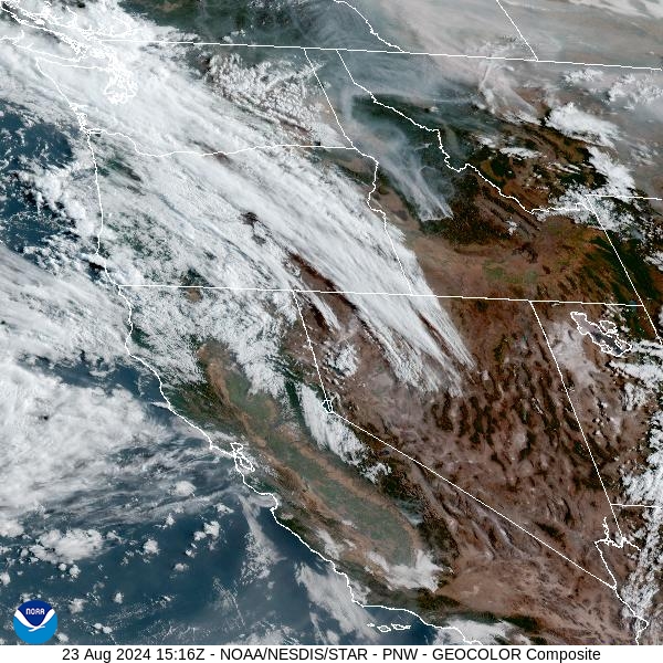
Source: NOAA
Forecast
A southerly to southwesterly flow will persist across the Treasure State through Saturday. Winds will be rather gusty, and this could produce erratic fire behavior on existing blazes. The flow will continue to pump smoke from fires burning in Idaho and Wyoming into Montana. Afternoon mixing heights remain elevated across the region, so much of the smoke from regional fires should stay aloft. Expect some draining and pooling of the smoke after sunset, as inversions develop. This could lead to localized air quality issues, particularly in communities adjacent to wildfires.
By late Saturday and Sunday, an area of low pressure marches across the state. The low will drag a cold front through the region, providing much cooler temperatures. Beneficial rain is likely across Central Idaho where numerous active fires are burning. Montana will also see precipitation from this system, particularly west of the Continental Divide. The moisture will help to moderate fire behavior across the region and limit smoke production.
The flow turns more zonal by early next week. This will produce more seasonable temperatures by Monday and Tuesday. A westerly flow will likely bring smoke from regional wildfires into Montana during this timeframe. Stay tuned!
By midday Saturday, the HRRR smoke model shows smoke moving into Montana from wildfires burning in Idaho and Wyoming.
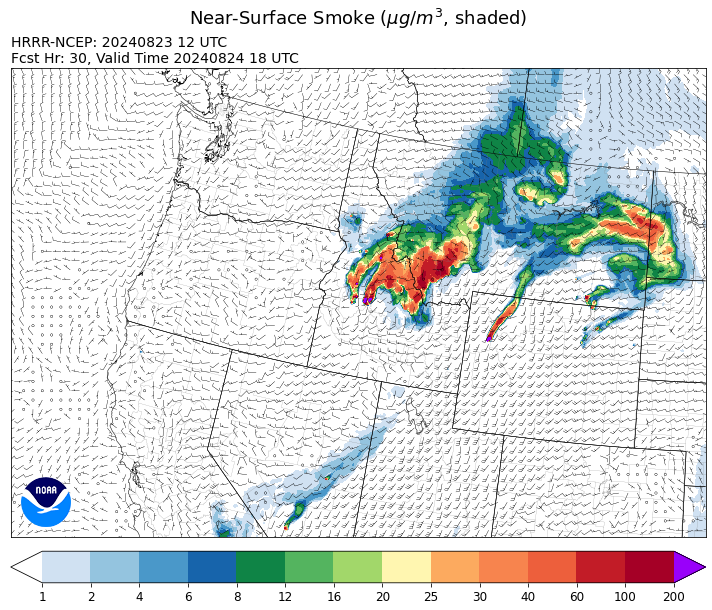
Source: HRRR Smoke
Conditions can change quickly as weather could stimulate active fires and the likelihood of new starts increases. Please keep track of concentrations at todaysair.mtdeq.us or the Fire and Smoke Map.
Current Wildfires
|
Incident |
State |
location |
acres |
containment |
|
Goat Fire - IDBOF |
Idaho |
11 miles SE of Cascade, Idaho |
1,963 |
0% |
|
Wolf Creek Fire - IDPAF |
Idaho |
5 miles west of Donnelly, ID |
1,154 |
95% |
|
Boulder Fire - IDBOF |
Idaho |
9 Miles southwest of Cascade, Idaho. |
2,313 |
44% |
|
Snag Fire - IDBOF |
Idaho |
9.5 miles East of Cascade, Idaho |
25,235 |
3% |
|
Dollar Fire - IDBOF |
Idaho |
18 miles NE of Cascade, Idaho |
2,665 |
0% |
|
Wapiti Fire - IDBOF |
Idaho |
2 miles southwest of Grandjean, ID |
35,631 |
10% |
|
2024 Flat - IDIDS |
Idaho |
One mile east of Pioneerville, Idaho |
3,719 |
43% |
|
Limepoint Fire - IDPAF |
Idaho |
8 miles NE of Oxbow Dam |
32,600 |
84% |
|
Middle Fork Complex Fire: Bulldog, Nellie, Anderson - IDBOF |
Idaho |
9 miles east of Garden Valley, ID |
36,773 |
5% |
|
Bulltrout Fire - IDBOF |
Idaho |
15 miles WNW OF Stanley, ID |
271 |
92% |
|
Cracker Jack Complex - IDNCF |
Idaho |
All four fires are located within half a mile of each other: two and a half miles east of Concord, ID, less than a quarter acre east from Square Lake and less than a quarter acre west from Fish Lake. |
702 |
NA |
|
Robbin Fire - IDNCF |
Idaho |
Within Game Unit 12: located less than six and a half miles southwest of Powell Ranger Station and less than three and a half miles south of Wendover Campground |
NA |
NA |
|
Grave Butte Fire - IDNCF |
Idaho |
Within Game Unit 12: located ten miles west of Jerry Johnson Campground and about half a mile from National Forest Service Road #107 (Saddle Camp Road) |
10 |
NA |
|
Boulder Creek Fire - IDNCF |
Idaho |
Within Game Unit 12: located ten miles north of the Powell Ranger Station and 12 miles west of Lolo Hot Springs |
25 |
NA |
|
Burnt Creek Fire - IDPAF |
Idaho |
NA |
300 |
NA |
|
Farrow Fire - IDPAF |
Idaho |
NA |
727 |
NA |
|
Parks Fire - IDPAF |
Idaho |
NA |
400 |
NA |
|
Bench Lake Fire - IDSTF |
Idaho |
8 miles south of Stanley, Idaho |
2,595 |
90% |
|
Monumental Fire - IDPAF |
Idaho |
NA |
11 |
NA |
|
Wye Fire - IDNCF |
Idaho |
Approximately four and a half miles northwest of Freeman Peak and seven miles northeast of the Moose Creek Airstrip |
5,015 |
NA |
|
Ace Butte Fire - IDNCF |
Idaho |
Approximately 30 miles Southeast of Grangeville, Idaho |
134 |
NA |
|
Anchor Fire - IDNCF |
Idaho |
About half way between Hanover Mountain and Square Mountain in the Gospel Hump Wilderness |
115 |
NA |
|
Ratio Mountain - MTBDF |
Montana |
15 miles northwest of Whitehall, MT. |
42 |
NA |
|
Elkhorn Ridge - MTBRF |
Montana |
West Fork District |
2,482 |
0% |
|
Pentagon Fire - MTFNF |
Montana |
45 miles SE of Bigfork, MT |
62 |
0% |
|
Grouse - MTBDF |
Montana |
Ten miles southwest of Wise River, MT |
4,200 |
22% |
|
Johnson Fire - MTBRF |
Montana |
3 miles west of the Springer Memorial Community in the East Fork on the Bitterroot NF |
270 |
0% |
|
Homestead Complex - ORUPF |
Oregon |
Thirty miles northeast of Glide Oregon |
5,898 |
38% |
|
Diamond Complex - ORUPF |
Oregon |
18 miles southwest of Chemult, Oregon |
11,106 |
56% |
|
Cottage Grove - Lane 1 - OR77S |
Oregon |
Approximately 16 miles SE of Springfield, OR |
25,265 |
85% |
|
North Willamette Complex - ORWIF |
Oregon |
Willamette National Forest |
4,452 |
NA |
|
Middle Fork Fire - ORCLP |
Oregon |
Crater Lake National Park; Middle Fork area |
5,244 |
0% |
|
Whisky Creek Fire - ORMHF |
Oregon |
East fork of Herman Creek, 6 miles SE of Cascade Locks, OR |
2,058 |
24% |
|
Sandstone Fire - ORMHF |
Oregon |
9 miles SW of Ripplebrook, OR, on the Mt. Hood National Forest |
702 |
29% |
|
Red Fire - ORDEF |
Oregon |
Diamond Peak Wilderness, 16 miles west, north-west of Crescent Oregon. |
738 |
0% |
|
Willamette Complex Fires - South - ORWIF |
Oregon |
Willamette Complex South fires are 8 miles north and 8 to 22 miles S-SE of Oakridge. |
13,038 |
NA |
|
Crazy Creek - OROCF |
Oregon |
Crazy Creek:16 miles north of Paulina, OR |
86,963 |
93% |
|
Dixon Fire - ORUPF |
Oregon |
Tiller, Oregon |
1,970 |
87% |
|
Battle Mountain Complex - OR97S |
Oregon |
West and south of Ukiah, OR |
183,026 |
94% |
|
Warner Peak Fire - ORSHR |
Oregon |
3 miles East of Plush, on the Hart Mountain Antelope Refuge |
65,866 |
85% |
|
Town Gulch - ORWWF |
Oregon |
Eagle Creek Rd Area, 24 Miles East of Baker City OR, 8 Miles N of Richland, OR |
18,220 |
89% |
|
Cliff Mountain - ORWWF |
Oregon |
25 Miles East of Joseph, Oregon |
1,108 |
75% |
|
Six Mile - WACOA |
Washington |
Two miles east of Nine Mile Hellgate Road, near the head of Cottonwood Creek |
113 |
60% |
|
Ruby Fire - WANCP |
Washington |
On Ruby Mountain in North Cascade National Park by Diablo and Ross Lake, 9 miles East of Newhalem |
955 |
0% |
|
Stranger Creek II - WACOA |
Washington |
NA |
66 |
60% |
|
Upper Ruby - WACOF |
Washington |
Ione, WA |
220 |
0% |
|
Easy Fire - WAOWF |
Washington |
North Cascades Hwy 20 Corridor, 17 air miles west of Mazama, WA |
2,130 |
36% |
|
Pioneer - WASES |
Washington |
Approximate start 10 miles southeast of Stehekin, WA |
38,730 |
23% |
|
2620 Road Fire - WAOLC |
Washington |
The fire is located 5 miles West of Brinnon Washington. |
403 |
15% |
|
Williams Mine Fire-GPNF - WAGPF |
Washington |
3.5 miles NNW of Trout Lake WA |
11,764 |
21% |
|
Pincer Two Fire - WAMSF |
Washington |
Johannesburg Mountain. 1 Mile East of Mineral Park Campground |
189 |
0% |
|
Wicked Drive - WANEC |
Washington |
Tum Tum, Washington |
698 |
65% |
|
Lodgepole - WAOWF |
Washington |
16 miles west of Cliffdell, WA |
35 |
6% |
|
Retreat - WASES |
Washington |
14 miles WSE of Naches, WA |
45,601 |
85% |
|
Cougar Creek Fire - WASES |
Washington |
1 mile west of Hwy 129 and Grand Ronde river intersection |
24,091 |
80% |
|
Kachess Complex - WAOWF |
Washington |
12 miles west of Cle Elum drainage |
23 |
NA |
|
House Draw Fire - WYHPD |
Wyoming |
Between Clearmont and Kaycee, WY |
163,466 |
0% |
|
Clearwater - WYSHF |
Wyoming |
11 Miles West of Wapiti, Wyoming |
1,966 |
75% |
|
Fish Creek Fire - WYBTF |
Wyoming |
Approximately 7 miles southwest of Togwotee Pass |
9,461 |
0% |
|
Leeds Creek - WYBTF |
Wyoming |
16 Miles Southwest of Dubois, WY |
780 |
75% |
Source: Inciweb
Tags: Smoke Forecast 2024