
Smoke Forecast for Thursday, August 22, 2024 9:30 AM
Current Conditions
Some beneficial rain fell across parts of Montana on Wednesday. Some areas of Southwest Montana received up to a quarter of an inch.
Unfortunately, the fires burning across the Central Idaho mountains didn’t receive any precipitation Wednesday. The Nellie and Wapiti fires were active on Wednesday, and smoke from these fires could be seen moving into Southwest Montana in the afternoon. Despite the plume, much of this smoke was aloft so there weren’t any major impacts to air quality. The Wye fire burning 30 miles west of Hamilton continues to expand. It has grown to 5,000 acres with 0% containment. By Wednesday afternoon, smoke from the Wye fire was visible across sections of the Bitterroot and Missoula Valleys.
The Fish Creek fire burning east of Jackson, Wyoming exhibited active fire behavior on Wednesday. As of Thursday morning, it had grown to 7,798 acres. Smoke from the fire could be seen drifting over parts of Southeast Montana, near Billings Wednesday afternoon.
At 9:00 AM Thursday, Dillon and Broadus were enduring Moderate air quality.
Thursday morning’s satellite shows some light smoke across Montana, much of which is aloft, from fires burning in Central Idaho.
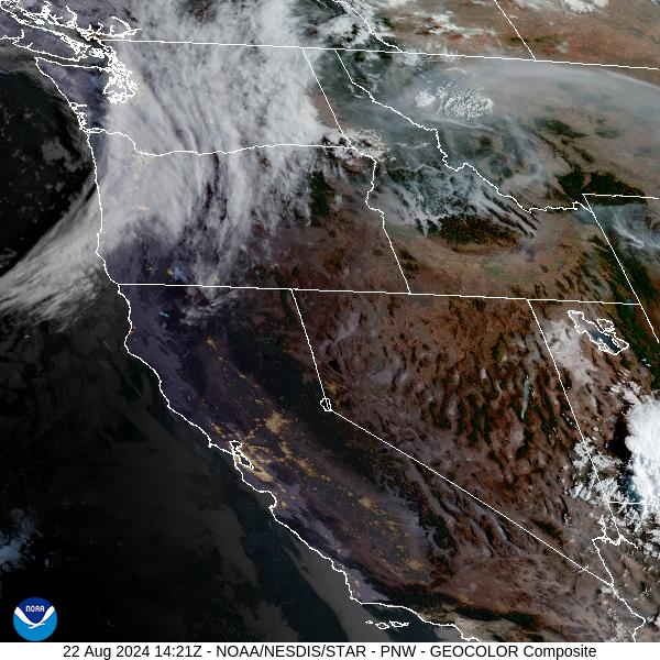
Source: NOAA
Forecast
A southwesterly to southerly flow will persist across the Northern Rockies through at least Saturday. This will continue to send smoke from fires burning in the Central Idaho mountains into portions of Western Montana. The Nellie, Wapiti, and Wye fires have grown considerably of late, and smoke from these blazes will continue to drift into the Treasure State.
Warmer air will be drawn north into Montana on Friday thanks to the southerly flow. Widely isolated showers and thunderstorms are possible, but much of the region should remain dry. Most of the smoke from regional wildfires will remain aloft during the day. However, expect some draining and pooling of the smoke overnight as inversions set-up, especially over Southwest Montana.
A much-anticipated Pacific trough swings through the Northern Rockies beginning Saturday bringing an end to the unseasonably warmth. It will provide some beneficial rain, even across the mountains of Central Idaho where numerous wildfires are burning. The moisture should help to moderate fire behavior and limit smoke production. Snow levels will tumble, and minor accumulations are possible down to 8,000 feet. Stay tuned!
By Friday afternoon, the HRRR smoke model shows smoke moving into Montana from wildfires burning in Idaho and Wyoming.
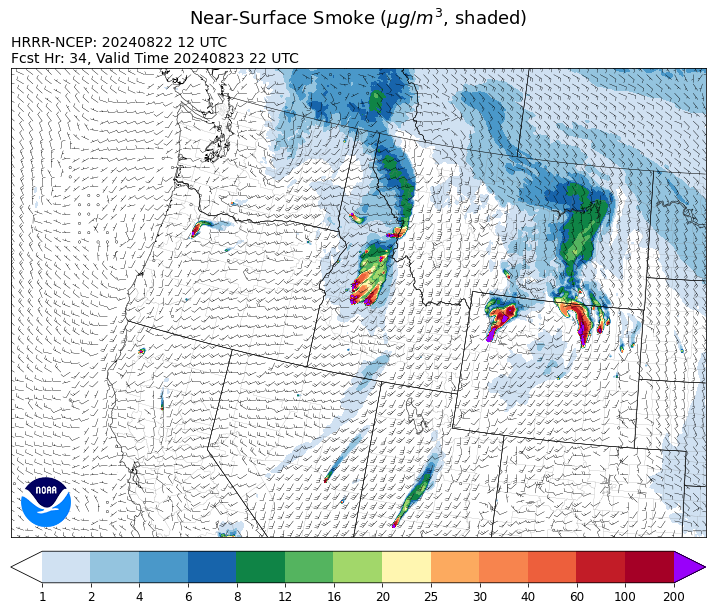
Source: HRRR Smoke
Conditions can change quickly as weather could stimulate active fires and the likelihood of new starts increases. Please keep track of concentrations at todaysair.mtdeq.us or the Fire and Smoke Map.
Current Wildfires
|
Incident |
State |
location |
acres |
containment |
|
Goat Fire - IDBOF |
Idaho |
11 miles SE of Cascade, Idaho |
1,718 |
0% |
|
Boulder Fire - IDBOF |
Idaho |
9 Miles southwest of Cascade, Idaho. |
2,305 |
44% |
|
Snag Fire - IDBOF |
Idaho |
9.5 miles East of Cascade, Idaho |
23,100 |
3% |
|
Dollar Fire - IDBOF |
Idaho |
18 miles NE of Cascade, Idaho |
2,449 |
0% |
|
Wolf Creek Fire - IDPAF |
Idaho |
5 miles west of Donnelly, ID |
1,154 |
95% |
|
Limepoint Fire - IDPAF |
Idaho |
8 miles NE of Oxbow Dam |
32,465 |
84% |
|
Bulltrout Fire - IDBOF |
Idaho |
15 miles WNW OF Stanley, ID |
271 |
92% |
|
Wapiti Fire - IDBOF |
Idaho |
2 miles southwest of Grandjean, ID |
17,520 |
10% |
|
Middle Fork Complex Fire: Bulldog, Nellie, Anderson - IDBOF |
Idaho |
9 miles east of Garden Valley, ID |
31,087 |
5% |
|
2024 Flat - IDIDS |
Idaho |
1 mile east of Pioneerville, ID |
3,668 |
28% |
|
Burnt Creek Fire - IDPAF |
Idaho |
NA |
300 |
NA |
|
Farrow Fire - IDPAF |
Idaho |
NA |
727 |
NA |
|
Parks Fire - IDPAF |
Idaho |
NA |
400 |
NA |
|
Bench Lake Fire - IDSTF |
Idaho |
8 miles south of Stanley, Idaho |
2,595 |
90% |
|
Monumental Fire - IDPAF |
Idaho |
NA |
11 |
NA |
|
Wye Fire - IDNCF |
Idaho |
Approximately four and a half miles northwest of Freeman Peak and seven miles northeast of the Moose Creek Airstrip |
5,015 |
NA |
|
Ace Butte Fire - IDNCF |
Idaho |
Approximately 30 miles Southeast of Grangeville, Idaho |
134 |
NA |
|
Anchor Fire - IDNCF |
Idaho |
About half way between Hanover Mountain and Square Mountain in the Gospel Hump Wilderness |
115 |
NA |
|
Cracker Jack Complex - IDNCF |
Idaho |
All four fires are located within half a mile of each other: two and a half miles east of Concord, ID, less than a quarter acre east from Square Lake and less than a quarter acre west from Fish Lake. |
265 |
NA |
|
Bluff Creek Complex - IDIPF |
Idaho |
The fires are burning along both sides of the Bluff Ridge, approximately 13 1/2 miles southeast of Avery, ID; five and a half miles west from Gold Creek Campground; and approximately two miles northwest of Junction Ridge. |
432 |
NA |
|
Elkhorn Ridge - MTBRF |
Montana |
West Fork District |
2482 |
0% |
|
Pentagon Fire - MTFNF |
Montana |
45 miles SE of Bigfork, MT |
62 |
0% |
|
Black Canyon Fire - MTMTS |
Montana |
30 Miles NW of White Sulphur Springs, MT |
233 |
100% |
|
Grouse - MTBDF |
Montana |
Ten miles southwest of Wise River, MT |
4,200 |
22% |
|
Johnson Fire - MTBRF |
Montana |
3 miles west of the Springer Memorial Community in the East Fork on the Bitterroot NF |
270 |
0% |
|
Willamette Complex Fires - South - ORWIF |
Oregon |
Willamette Complex South fires are 8 miles north and 8 to 22 miles S-SE of Oakridge. |
13,013 |
NA |
|
Cottage Grove - Lane 1 - OR77S |
Oregon |
Approximately 16 miles SE of Springfield, OR |
25,265 |
81% |
|
Red Fire - ORDEF |
Oregon |
Diamond Peak Wilderness, 16 miles west, north-west of Crescent Oregon. |
738 |
0% |
|
Sandstone Fire - ORMHF |
Oregon |
9 miles SW of Ripplebrook, OR, on the Mt. Hood National Forest |
702 |
29% |
|
Homestead Complex - ORUPF |
Oregon |
Thirty miles northeast of Glide Oregon |
5,891 |
35% |
|
Whisky Creek Fire - ORMHF |
Oregon |
East fork of Herman Creek, 6 miles SE of Cascade Locks, OR |
2,058 |
24% |
|
Diamond Complex - ORUPF |
Oregon |
18 miles southwest of Chemult, Oregon |
11,052 |
53% |
|
Middle Fork Fire - ORCLP |
Oregon |
Crater Lake National Park; Middle Fork area |
5,228 |
0% |
|
North Willamette Complex - ORWIF |
Oregon |
Willamette National Forest |
4,458 |
NA |
|
Crazy Creek - OROCF |
Oregon |
Crazy Creek:16 miles north of Paulina, OR |
86,963 |
93% |
|
Dixon Fire - ORUPF |
Oregon |
Tiller, Oregon |
1,970 |
87% |
|
Battle Mountain Complex - OR97S |
Oregon |
West and south of Ukiah, OR |
183,026 |
94% |
|
Warner Peak Fire - ORSHR |
Oregon |
3 miles East of Plush, on the Hart Mountain Antelope Refuge |
65,866 |
85% |
|
Town Gulch - ORWWF |
Oregon |
Eagle Creek Rd Area, 24 Miles East of Baker City OR, 8 Miles N of Richland, OR |
18,220 |
89% |
|
Cliff Mountain - ORWWF |
Oregon |
25 Miles East of Joseph, Oregon |
1,108 |
75% |
|
Williams Mine Fire-GPNF - WAGPF |
Washington |
3.5 miles NNW of Trout Lake WA |
11,764 |
19% |
|
2620 Road Fire - WAOLC |
Washington |
The fire is located 5 miles West of Brinnon Washington. |
403 |
8% |
|
Easy Fire - WAOWF |
Washington |
North Cascades Hwy 20 Corridor, 17 air miles west of Mazama, WA |
2,130 |
36% |
|
Pioneer - WASES |
Washington |
Approximate start 10 miles southeast of Stehekin, WA |
38,730 |
23% |
|
Stranger Creek II - WACOA |
Washington |
NA |
66 |
0% |
|
Pincer Two Fire - WAMSF |
Washington |
Johannesburg Mountain. 1 Mile East of Mineral Park Campground |
189 |
0% |
|
Six Mile - WACOA |
Washington |
Two miles east of Nine Mile Hellgate Road, near the head of Cottonwood Creek |
113 |
0% |
|
Ruby Fire - WANCP |
Washington |
On Ruby Mountain in North Cascade National Park by Diablo and Ross Lake, 9 miles East of Newhalem |
921 |
0% |
|
Upper Ruby - WACOF |
Washington |
Ione, WA |
220 |
0% |
|
Wicked Drive - WANEC |
Washington |
Tum Tum, Washington |
698 |
65% |
|
Lodgepole - WAOWF |
Washington |
16 miles west of Cliffdell, WA |
35 |
6% |
|
Retreat - WASES |
Washington |
14 miles WSE of Naches, WA |
45,601 |
85% |
|
Cougar Creek Fire - WASES |
Washington |
1 mile west of Hwy 129 and Grand Ronde river intersection |
24,091 |
80% |
|
Kachess Complex - WAOWF |
Washington |
12 miles west of Cle Elum drainage |
23 |
NA |
Source: Inciweb
Tags: Smoke Forecast 2024