
Smoke Forecast for Wednesday, August 21, 2024
Current Conditions
Beneficial rain fell across much of Montana again on Tuesday. The precipitation was accompanied by numerous lightning strikes and new fire starts are possible in the coming days.
Unfortunately, the Wye fire burning in the Bitterroot Mountains of Idaho about 30 miles west of Hamilton didn’t receive any rain on Tuesday. The fire has burned 4,551 acres with 0% of the fire contained. A crew of 4 people are assigned to the Wye fire. The fire will continue to send smoke into portions of Western Montana.
Through Tuesday morning, there have been 1,600 fires in Montana that have burned a total of 113,613 acres.
At 9:00 AM Tuesday, Libby, Dillon, Great Falls, Broadus, Miles City, Glendive, and Sidney were enduring Moderate air quality.
Wednesday morning’s satellite shows some smoke over Montana as a trough shifts across the Northern Rockies providing clouds and even some light rain.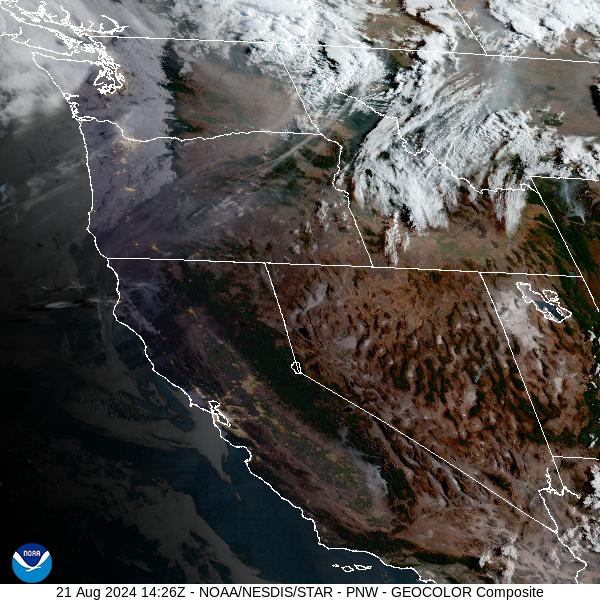
Source: NOAA
Forecast
While parts of Montana received beneficial rain on Tuesday, much of Central Idaho where several large active fires are burning did not. A southwesterly flow will continue Wednesday, pumping smoke from these Idaho fires into the western half of Montana. Fortunately, much of this smoke will remain aloft, so there won’t be any significant impacts to surface air quality.
A trough marches across the region on Wednesday. It will be the focus for another round of showers and thunderstorms for Montana. Some of the storms could contain frequent lightning and gusty winds. The trough exits on Thursday, allowing temperatures to quickly warm-up. The low pressure off the coast of British Columbia sags south, bringing even warmer air to Montana by Friday. A southwesterly flow will persist through Friday, which should keep at least some light smoke from Idaho wildfires over the western half of the state.
A trough begins to move over the Northern Rockies by Friday night. It will provide some much-needed rain for the region. Even the fires burning in Central Idaho will see some rain, which will eventually limit smoke production downstream in Montana. Cooler air with good chances for rain will persist into the upcoming weekend.
By midday Thursday, the HRRR smoke model shows smoke moving into Southwest Montana from fires burning in the mountains of Central Idaho.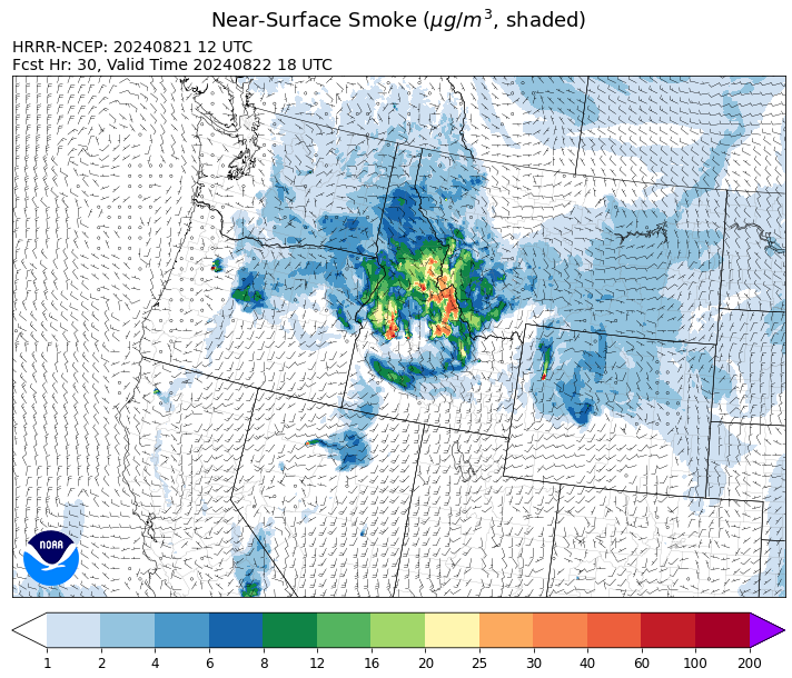
Source: HRRR Smoke
Conditions can change quickly as weather could stimulate active fires and the likelihood of new starts increases. Please keep track of concentrations at todaysair.mtdeq.us or the Fire and Smoke Map.
Current Wildfires
|
Incident |
State |
location |
acres |
containment |
|
Middle Fork Complex Fire - IDBOF |
Idaho |
9 miles east of Garden Valley, ID |
28,052 |
5% |
|
Boulder Fire - IDBOF |
Idaho |
9 Miles southwest of Cascade, Idaho. |
2,305 |
39% |
|
Goat Fire - IDBOF |
Idaho |
11 miles SE of Cascade, Idaho |
1,718 |
0% |
|
Dollar Fire - IDBOF |
Idaho |
18 miles NE of Cascade, Idaho |
2,449 |
0% |
|
Wolf Creek Fire - IDPAF |
Idaho |
5 miles west of Donnelly, ID |
1,154 |
95% |
|
Snag Fire - IDBOF |
Idaho |
9.5 miles East of Cascade, Idaho |
23,100 |
2% |
|
Limepoint Fire - IDPAF |
Idaho |
8 miles NE of Oxbow Dam |
32,439 |
82% |
|
2024 Flat - IDIDS |
Idaho |
1 mile east of Pioneerville, ID |
3,668 |
24% |
|
Bulltrout Fire - IDBOF |
Idaho |
15 miles WNW OF Stanley, ID |
271 |
92% |
|
Wapiti Fire - IDBOF |
Idaho |
2 miles southwest of Grandjean, ID |
13,997 |
10% |
|
Monumental Fire - IDPAF |
Idaho |
NA |
11 |
NA |
|
Burnt Creek Fire - IDPAF |
Idaho |
NA |
200 |
NA |
|
Farrow Fire - IDPAF |
Idaho |
NA |
500 |
NA |
|
Wye Fire - IDNCF |
Idaho |
Approximately four and a half miles northwest of Freeman Peak and seven miles northeast of the Moose Creek Airstrip |
5,015 |
NA |
|
Ace Butte Fire - IDNCF |
Idaho |
Approximately 30 miles Southeast of Grangeville, Idaho |
134 |
NA |
|
Anchor Fire - IDNCF |
Idaho |
About half way between Hanover Mountain and Square Mountain in the Gospel Hump Wilderness |
115 |
NA |
|
Cracker Jack Complex - IDNCF |
Idaho |
All four fires are located within half a mile of each other: two and a half miles east of Concord, ID, less than a quarter acre east from Square Lake and less than a quarter acre west from Fish Lake. |
265 |
NA |
|
Bluff Creek Complex - IDIPF |
Idaho |
The fires are burning along both sides of the Bluff Ridge, approximately 13 1/2 miles southeast of Avery, ID; five and a half miles west from Gold Creek Campground; and approximately two miles northwest of Junction Ridge. |
432 |
NA |
|
Elkhorn Ridge - MTBRF |
Montana |
West Fork District |
2,482 |
0% |
|
Pentagon Fire - MTFNF |
Montana |
45 miles SE of Bigfork, MT |
62 |
0% |
|
Black Canyon Fire - MTMTS |
Montana |
30 Miles NW of White Sulphur Springs, MT |
233 |
100% |
|
Grouse - MTBDF |
Montana |
Ten miles southwest of Wise River, MT |
4,200 |
22% |
|
Johnson Fire - MTBRF |
Montana |
3 miles west of the Springer Memorial Community in the East Fork on the Bitterroot NF |
270 |
0% |
|
Black Mountain - MTHLF |
Montana |
6 miles northwest of Lincoln. Mont. |
182 |
87% |
|
Crazy Creek - OROCF |
Oregon |
Crazy Creek:16 miles north of Paulina, OR |
86,963 |
93% |
|
Willamette Complex Fires - South - ORWIF |
Oregon |
Willamette Complex South fires are 8 miles north and 8 to 22 miles S-SE of Oakridge. |
13,013 |
NA |
|
Dixon Fire - ORUPF |
Oregon |
Tiller, Oregon |
1,970 |
87% |
|
Cottage Grove - Lane 1 - OR77S |
Oregon |
Approximately 16 miles SE of Springfield, OR |
25,255 |
74% |
|
Sandstone Fire - ORMHF |
Oregon |
9 miles SW of Ripplebrook, OR, on the Mt. Hood National Forest |
702 |
29% |
|
Whisky Creek Fire - ORMHF |
Oregon |
East fork of Herman Creek, 6 miles SE of Cascade Locks, OR |
2,057 |
9% |
|
Diamond Complex - ORUPF |
Oregon |
18 miles southwest of Chemult, Oregon |
10,986 |
38% |
|
Homestead Complex - ORUPF |
Oregon |
Thirty miles northeast of Glide Oregon |
5,880 |
35% |
|
Middle Fork Fire - ORCLP |
Oregon |
Crater Lake National Park; Middle Fork area |
5,222 |
0% |
|
Telephone Fire - ORMAF |
Oregon |
16 miles north east of Burns, Oregon |
54,034 |
95% |
|
Falls Fire - ORMAF |
Oregon |
20 miles NW of Burns |
151,680 |
95% |
|
Red Fire - ORDEF |
Oregon |
Diamond Peak Wilderness, 16 miles west, north-west of Crescent Oregon. |
737 |
0% |
|
North Willamette Complex - ORWIF |
Oregon |
Willamette National Forest |
4,458 |
NA |
|
Battle Mountain Complex - OR97S |
Oregon |
West and south of Ukiah, OR |
183,026 |
94% |
|
Warner Peak Fire - ORSHR |
Oregon |
3 miles East of Plush, on the Hart Mountain Antelope Refuge |
65,866 |
85% |
|
Town Gulch - ORWWF |
Oregon |
Eagle Creek Rd Area, 24 Miles East of Baker City OR, 8 Miles N of Richland, OR |
18,220 |
89% |
|
Cliff Mountain - ORWWF |
Oregon |
25 Miles East of Joseph, Oregon |
1,108 |
75% |
|
Easy Fire - WAOWF |
Washington |
North Cascades Hwy 20 Corridor, 17 air miles west of Mazama, WA |
2,130 |
36% |
|
Pioneer - WASES |
Washington |
Approximate start 10 miles southeast of Stehekin, WA |
38,730 |
23% |
|
Ruby Fire - WANCP |
Washington |
On Ruby Mountain in North Cascade National Park by Diablo and Ross Lake, 9 miles East of Newhalem |
921 |
0% |
|
2620 Road Fire - WAOLC |
Washington |
The fire is located 5 miles West of Brinnon Washington. |
398 |
8% |
|
Upper Ruby - WACOF |
Washington |
Ione, WA |
220 |
0% |
|
Wicked Drive - WANEC |
Washington |
Tum Tum, Washington |
698 |
65% |
|
Six Mile - WACOA |
Washington |
Two miles east of Nine Mile Hellgate Road, near the head of Cottonwood Creek |
113 |
0% |
|
Stranger Creek II - WACOA |
Washington |
NA |
66 |
0% |
|
Pincer Two Fire - WAMSF |
Washington |
Johannesburg Mountain. 1 Mile East of Mineral Park Campground |
189 |
0% |
|
Williams Mine Fire-GPNF - WAGPF |
Washington |
3.5 miles NNW of Trout Lake WA |
11,696 |
13% |
|
Lodgepole - WAOWF |
Washington |
16 miles west of Cliffdell, WA |
35 |
6% |
|
Retreat - WASES |
Washington |
14 miles WSE of Naches, WA |
45,601 |
85% |
|
Cougar Creek Fire - WASES |
Washington |
1 mile west of Hwy 129 and Grand Ronde river intersection |
24,091 |
80% |
|
Kachess Complex - WAOWF |
Washington |
12 miles west of Cle Elum drainage |
23 |
NA |
Source: Inciweb
Tags: Smoke Forecast 2024