
Smoke Forecast for Monday, August 19, 2024 10:00 AM
Current Conditions
Several active fires burning in the Boise National Forest in Idaho quickly expanded on Sunday. The smoke from these fires was forced north by southerly winds and was observed over parts of Northwest Montana. However, much of this smoke remains elevated several thousand feet above the surface, so air quality isn’t a major concern.
The Wye fire burning in the Bitterroot Mountains of Idaho about 30 miles west of Hamilton continues to grow. It is up to 5,015 acres with 0% of the fire contained. A crew of 4 people are assigned to the Wye fire.
At 9:00 AM Monday, Great Falls and Sidney were enduring Moderate air quality.
Monday morning’s satellite shows some smoke from Idaho wildfires surging north into Western Montana.
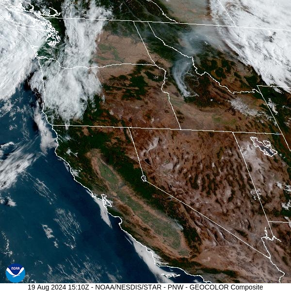
Source: NOAA
Forecast
Surface winds turn from the south to the west across the Northern Rockies over the next 24-hours. This pattern will send more smoke from Idaho wildfires into the Treasure State, particularly over the Bitterroot Valley and Northwest Montana. Per Inciweb, there are currently 18 active wildfires burning in Idaho covering more than 90,000 acres total.
Scattered showers and thunderstorms are possible Monday and Tuesday across the region. These storms will be capable of producing heavy rain, frequent lightning, gusty winds, and even some hail. Existing fires adjacent to these storms will exhibit erratic behavior due to strong outflow winds. While these storms will produce some beneficial rainfall for much of Montana, they will largely avoid central and southern Idaho where numerous wildfires are burning. Smoke from Idaho wildfires will be an ongoing issue, particularly in Western Montana, as the week goes on.
A ridge of high pressure will bring unseasonably warm air to Montana, especially the first half of the week. By the end of the week, a trough will push inland. It will provide much cooler temperatures and the threat of showers and thunderstorms. Stay tuned!
By late Tuesday, the HRRR smoke model shows smoke moving into Western Montana from fires burning in Idaho.
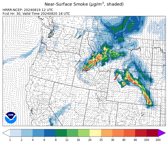
Source: HRRR Smoke
Conditions can change quickly as weather could stimulate active fires and the likelihood of new starts increases. Please keep track of concentrations at todaysair.mtdeq.us or the Fire and Smoke Map.
Current Wildfires
|
Incident |
State |
location |
acres |
containment |
|
Wapiti Fire - IDBOF |
Idaho |
2 miles southwest of Grandjean, ID |
4,943 |
10% |
|
Dollar Fire - IDBOF |
Idaho |
18 miles NE of Cascade, Idaho |
1,865 |
0% |
|
Goat Fire - IDBOF |
Idaho |
11 miles SE of Cascade, Idaho |
1,405 |
0% |
|
Boulder Fire - IDBOF |
Idaho |
9 Miles southwest of Cascade, Idaho. |
2,288 |
35% |
|
Snag Fire - IDBOF |
Idaho |
9.5 miles East of Cascade, Idaho |
21,464 |
0% |
|
Wolf Creek Fire - IDPAF |
Idaho |
5 miles west of Donnelly, ID |
1,154 |
95% |
|
Limepoint Fire - IDPAF |
Idaho |
8 miles NE of Oxbow Dam |
32,212 |
58% |
|
Bulltrout Fire - IDBOF |
Idaho |
15 miles WNW OF Stanley, ID |
271 |
92% |
|
Middle Fork Complex Fire: Bulldog, Nellie, Anderson - IDBOF |
Idaho |
9 miles east of Garden Valley, ID |
15,629 |
5% |
|
Wye Fire - IDNCF |
Idaho |
Approximately four and a half miles northwest of Freeman Peak and seven miles northeast of the Moose Creek Airstrip |
5,015 |
NA |
|
Ace Butte Fire - IDNCF |
Idaho |
Approximately 30 miles Southeast of Grangeville, Idaho |
134 |
NA |
|
Anchor Fire - IDNCF |
Idaho |
About half way between Hanover Mountain and Square Mountain in the Gospel Hump Wilderness |
115 |
NA |
|
Cracker Jack Complex - IDNCF |
Idaho |
All four fires are located within half a mile of each other: two and a half miles east of Concord, ID, less than a quarter acre east from Square Lake and less than a quarter acre west from Fish Lake. |
265 |
NA |
|
2024 Flat - IDIDS |
Idaho |
NA |
3,278 |
14% |
|
Farrow Fire - IDPAF |
Idaho |
NA |
500 |
NA |
|
Bluff Creek Complex - IDIPF |
Idaho |
The fires are burning along both sides of the Bluff Ridge, approximately 13 1/2 miles southeast of Avery, ID; five and a half miles west from Gold Creek Campground; and approximately two miles northwest of Junction Ridge. |
432 |
NA |
|
Monumental Fire - IDPAF |
Idaho |
NA |
11 |
NA |
|
Black Canyon Fire - MTMTS |
Montana |
30 Miles NW of White Sulphur Springs, MT |
233 |
98% |
|
Miller Peak Fire - MTLNF |
Montana |
7 miles southeast of Missoula |
2,724 |
86% |
|
Grouse - MTBDF |
Montana |
Ten miles southwest of Wise River, MT |
4,166 |
22% |
|
Johnson Fire - MTBRF |
Montana |
3 miles west of the Springer Memorial Community in the East Fork on the Bitterroot NF |
270 |
0% |
|
Elkhorn Ridge - MTBRF |
Montana |
West Fork District |
2,482 |
0% |
|
Pentagon Fire - MTFNF |
Montana |
45 miles SE of Bigfork, MT |
62 |
0% |
|
Black Mountain - MTHLF |
Montana |
6 miles northwest of Lincoln. Mont. |
182 |
87% |
|
Telephone Fire - ORMAF |
Oregon |
16 miles north east of Burns, Oregon |
54,034 |
95% |
|
Falls Fire - ORMAF |
Oregon |
20 miles NW of Burns |
151,680 |
95% |
|
North Willamette Complex - ORWIF |
Oregon |
Willamette National Forest |
4,452 |
NA |
|
Willamette Complex Fires - South - ORWIF |
Oregon |
Willamette Complex South fires are 8 miles north and 8 to 22 miles S-SE of Oakridge. |
12,945 |
48% |
|
Homestead Complex - ORUPF |
Oregon |
Thirty miles northeast of Glide Oregon |
5,832 |
31% |
|
Whisky Creek Fire - ORMHF |
Oregon |
East fork of Herman Creek, 6 miles SE of Cascade Locks, OR |
1,973 |
9% |
|
Sandstone Fire - ORMHF |
Oregon |
9 miles SW of Ripplebrook, OR, on the Mt. Hood National Forest |
702 |
19% |
|
Cottage Grove - Lane 1 - OR77S |
Oregon |
Approximately 16 miles SE of Springfield, OR |
25,250 |
61% |
|
Middle Fork Fire - ORCLP |
Oregon |
Crater Lake National Park; Middle Fork area |
5,222 |
0% |
|
Diamond Complex - ORUPF |
Oregon |
18 miles southwest of Chemult, Oregon |
10,984 |
33% |
|
Dixon Fire - ORUPF |
Oregon |
Tiller, Oregon |
1,970 |
47% |
|
Battle Mountain Complex - OR97S |
Oregon |
West and south of Ukiah, OR |
183,026 |
94% |
|
Red Fire - ORDEF |
Oregon |
Diamond Peak Wilderness, 16 miles west, north-west of Crescent Oregon. |
730 |
0% |
|
Warner Peak Fire - ORSHR |
Oregon |
3 miles East of Plush, on the Hart Mountain Antelope Refuge |
65,866 |
85% |
|
Crazy Creek - OROCF |
Oregon |
Crazy Creek:16 miles north of Paulina, OR |
86,928 |
93% |
|
Courtrock Fire - OR95S |
Oregon |
7.1 Miles south of Monument, OR |
20,019 |
100% |
|
Town Gulch - ORWWF |
Oregon |
Eagle Creek Rd Area, 24 Miles East of Baker City OR, 8 Miles N of Richland, OR |
18,220 |
89% |
|
Winding Waters Complex - OR97S |
Oregon |
23 miles east of Union, OR |
752 |
83% |
|
Cliff Mountain - ORWWF |
Oregon |
25 Miles East of Joseph, Oregon |
1,108 |
75% |
|
Porcupine Fire - ORBUD |
Oregon |
Porcupine Reservoir |
6,491 |
95% |
|
Lone Rock Fire - ORPRD |
Oregon |
Lonerock stretching to west of HWY 207 and south to HWY 19 |
137,222 |
98% |
|
Williams Mine Fire-GPNF - WAGPF |
Washington |
3.5 miles NNW of Trout Lake WA |
11,555 |
5% |
|
Cougar Creek Fire - WASES |
Washington |
1 mile west of Hwy 129 and Grand Ronde river intersection |
24,091 |
80% |
|
Ruby Fire - WANCP |
Washington |
On Ruby Mountain in North Cascade National Park by Diablo and Ross Lake, 9 miles East of Newhalem |
820 |
0% |
|
Pioneer - WASES |
Washington |
Approximate start 10 miles southeast of Stehekin, WA |
38,727 |
23% |
|
Easy Fire - WAOWF |
Washington |
North Cascades Hwy 20 Corridor, 17 air miles west of Mazama, WA |
2,130 |
29% |
|
Retreat - WASES |
Washington |
14 miles WSE of Naches, WA |
45,601 |
85% |
|
Lodgepole - WAOWF |
Washington |
16 miles west of Cliffdell, WA |
35 |
6% |
|
2620 Road Fire - WAOLC |
Washington |
The fire is located 5 miles West of Brinnon Washington. |
322 |
8% |
|
Kachess Complex - WAOWF |
Washington |
12 miles west of Cle Elum drainage |
23 |
NA |
|
Pincer Two Fire - WAMSF |
Washington |
Johannesburg Mountain. 1 Mile East of Mineral Park Campground |
189 |
0% |
Source: Inciweb
Tags: Smoke Forecast 2024