
Smoke Forecast for Friday, August 16, 2024 9:30 AM
Current Conditions
Beneficial rain fell across much of Montana again on Thursday. It helped to moderate fire behavior on existing fires and limit smoke production. Smoke from Canadian wildfires remains a concern across much of the eastern half of the state.
If you are experiencing issues accessing Today's Air, clear the cache in your browser and try again in a new tab.
The Grouse fire burning in the Pioneer Mountains southwest of Wise River remains the wildfire of greatest concern in the state. It has grown to 4,166 acres with 22% of the fire contained. A crew of 119 people are assigned to the Grouse fire. The town of Wise River received almost a quarter of an inch of rain on Thursday, which likely helped moderate fire behavior on this wildfire.
At 9:00 AM Friday, Libby, Thompson Falls, Great Falls, Malta, Sidney, Glendive, and Broadus were enduring Moderate air quality. Miles City, Havre, and Lewistown were experiencing air that is considered Unhealthy for Sensitive Groups.
Friday morning’s satellite shows some heavier plumes of smoke over parts of Northeast Montana from wildfires burning in Canada.
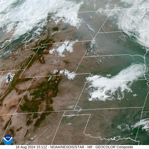
Source: NOAA
Forecast
Surface smoke from Canadian wildfires will become less of a concern across Northeast Montana on Friday. A southwesterly flow will slowly disperse the smoke over this area. As a result, air quality values should gradually improve.
A stagnant weather pattern will be the theme across the Northern Rockies and Pacific Northwest for the foreseeable future. An area of low pressure will deepen along the Pacific coast, keeping things cool and unsettled in much of Washington and Oregon. At the same time, a strong area of high pressure will park itself over the Great Plains, including the eastern half of Montana. This places much of the Treasure State in a southwesterly flow, pumping monsoonal moisture into the state. It will also bring smoke from fires burning in Oregon and Idaho to the area.
The southwesterly flow will also bring daily chances for showers and storms. Because of the proximity of a low to the west and high pressure to the east, there will be a giant range in temperatures across the state, with triple digit heat possible under the ridge and more seasonable temperatures in Western Montana. The area of low pressure starts to push the ridge slightly east by the end of next week, providing more typical temperatures for all of Montana.
By late Saturday, the HRRR smoke model shows the light smoke across Northeast Montana gradually dissipating.
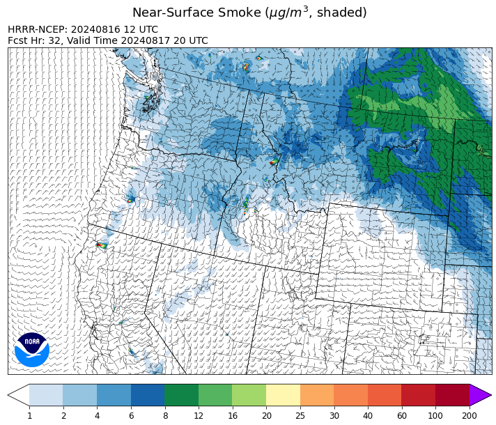
Source: HRRR Smoke
Conditions can change quickly as weather could stimulate active fires and the likelihood of new starts increases. Please keep track of concentrations at todaysair.mtdeq.us or the Fire and Smoke Map.
Current Wildfires
|
Incident |
State |
location |
acres |
containment |
|
Wolf Creek Fire - IDPAF |
Idaho |
5 miles west of Donnelly, ID |
1,154 |
81% |
|
Snag Fire - IDBOF |
Idaho |
9.5 miles East of Cascade, Idaho |
19,825 |
0% |
|
Dollar Fire - IDBOF |
Idaho |
18 mi. NE of Cascade, Idaho |
1,675 |
3% |
|
Boulder Fire - IDBOF |
Idaho |
9 Miles southwest of Cascade, Idaho. |
1,968 |
11% |
|
Goat Fire - IDBOF |
Idaho |
11 miles SE of Cascade, Idaho |
999 |
0% |
|
Middle Fork Complex Fire: Bulldog, Nellie, Anderson - IDBOF |
Idaho |
9 miles east of Garden Valley, ID |
9,207 |
0% |
|
Bulltrout Fire - IDBOF |
Idaho |
15 miles WNW OF Stanley, ID |
271 |
92% |
|
Wapiti Fire - IDBOF |
Idaho |
2 miles southwest of Grandjean, ID |
3,872 |
0% |
|
Limepoint Fire - IDPAF |
Idaho |
8 miles NE of Oxbow Dam |
31,545 |
42% |
|
2024 Flat - IDIDS |
Idaho |
NA |
3,115 |
14% |
|
Paddock - IDBOD |
Idaho |
20 miles north of Emmett, Idaho |
187,185 |
93% |
|
Farrow Fire - IDPAF |
Idaho |
NA |
500 |
NA |
|
Bluff Creek Complex - IDIPF |
Idaho |
The fires are burning along both sides of the Bluff Ridge, approximately 13 1/2 miles southeast of Avery, ID; five and a half miles west from Gold Creek Campground; and approximately two miles northwest of Junction Ridge. |
432 |
NA |
|
Payette Wilderness Fires - IDPAF |
Idaho |
NA |
NA |
NA |
|
Cracker Jack Complex - IDNCF |
Idaho |
All four fires are located within half a mile of each other: two and a half miles east of Concord, ID, less than a quarter acre east from Square Lake and less than a quarter acre west from Fish Lake. |
89 |
NA |
|
Monumental Fire - IDPAF |
Idaho |
NA |
11 |
NA |
|
Wye Fire - IDNCF |
Idaho |
Approximately four and a half miles northwest of Freeman Peak and seven miles northeast of the Moose Creek Airstrip |
4,451 |
NA |
|
Ace Butte Fire - IDNCF |
Idaho |
Approximately 30 miles Southeast of Grangeville, Idaho |
64 |
NA |
|
Anchor Fire - IDNCF |
Idaho |
About half way between Hanover Mountain and Square Mountain in the Gospel Hump Wilderness |
72 |
NA |
|
Grouse - MTBDF |
Montana |
Ten miles southwest of Wise River, MT |
4,166 |
22% |
|
Black Canyon Fire - MTMTS |
Montana |
30 Miles NW of White Sulphur Springs, MT |
233 |
20% |
|
Elkhorn Ridge - MTBRF |
Montana |
West Fork District |
2,482 |
0% |
|
Miller Peak Fire - MTLNF |
Montana |
7 miles southeast of Missoula |
2,724 |
86% |
|
Johnson Fire - MTBRF |
Montana |
3 miles west of the Springer Memorial Community in the East Fork on the Bitterroot NF |
270 |
0% |
|
Black Mountain - MTHLF |
Montana |
6 miles northwest of Lincoln. Mont. |
182 |
87% |
|
Pentagon Fire - MTFNF |
Montana |
45 miles SE of Bigfork, MT |
62 |
0% |
|
North Willamette Complex - ORWIF |
Oregon |
Willamette National Forest |
4,268 |
NA |
|
Homestead Complex - ORUPF |
Oregon |
Thirty miles northeast of Glide Oregon |
5,597 |
25% |
|
Willamette Complex Fires - South - ORWIF |
Oregon |
Willamette Complex South fires are 8 miles north and 8 to 22 miles S-SE of Oakridge. |
12,737 |
48% |
|
Warner Peak Fire - ORSHR |
Oregon |
3 miles East of Plush, on the Hart Mountain Antelope Refuge |
65,002 |
51% |
|
Cottage Grove - Lane 1 - OR77S |
Oregon |
Approximately 16 miles SE of Springfield, OR |
24,934 |
37% |
|
Cliff Mountain - ORWWF |
Oregon |
25 Miles East of Joseph, Oregon |
1,108 |
75% |
|
Dixon Fire - ORUPF |
Oregon |
Tiller, Oregon |
1,997 |
11% |
|
Diamond Complex - ORUPF |
Oregon |
18 miles southwest of Chemult, Oregon |
9,930 |
29% |
|
Telephone Fire - ORMAF |
Oregon |
16 miles north east of Burns, Oregon |
54,034 |
95% |
|
Falls Fire - ORMAF |
Oregon |
20 miles NW of Burns |
151,680 |
95% |
|
Middle Fork Fire - ORCLP |
Oregon |
Crater Lake National Park; Middle Fork area |
5,075 |
0% |
|
Crazy Creek - OROCF |
Oregon |
Crazy Creek:16 miles north of Paulina, OR |
86,870 |
71% |
|
Town Gulch - ORWWF |
Oregon |
Eagle Creek Rd Area, 24 Miles East of Baker City OR, 8 Miles N of Richland, OR |
18,215 |
79% |
|
Red Fire - ORDEF |
Oregon |
Diamond Peak Wilderness |
659 |
0% |
|
Whisky Creek Fire - ORMHF |
Oregon |
East fork of Herman Creek, 6 miles SE of Cascade Locks, OR |
1,938 |
9% |
|
Sandstone Fire - ORMHF |
Oregon |
9 miles SW of Ripplebrook, OR, on the Mt. Hood National Forest |
696 |
10% |
|
Courtrock Fire - OR95S |
Oregon |
7.1 Miles south of Monument, OR |
20,019 |
99% |
|
Porcupine Fire - ORBUD |
Oregon |
Porcupine Reservoir |
6,491 |
95% |
|
Lone Rock Fire - ORPRD |
Oregon |
Lonerock stretching to west of HWY 207 and south to HWY 19 |
137,222 |
98% |
|
Badland Complex 2024 - ORVAD |
Oregon |
Baker County, Oregon |
54,563 |
99% |
|
Microwave Tower Fire - OR95S |
Oregon |
1 mile WSW of Mosier, OR |
1,313 |
95% |
|
Ruby Fire - WANCP |
Washington |
On Ruby Mountain in North Cascade National Park by Diablo and Ross Lake, 9 miles East of Newhalem |
820 |
0% |
|
Williams Mine Fire-GPNF - WAGPF |
Washington |
3.5 miles NNW of Trout Lake WA |
11,302 |
2% |
|
Retreat - WASES |
Washington |
14 miles WSE of Naches, WA |
45,601 |
80% |
|
Lodgepole - WAOWF |
Washington |
16 miles west of Cliffdell, WA |
35 |
5% |
|
Kachess Complex - WAOWF |
Washington |
12 miles west of Cle Elum drainage |
22 |
50% |
|
Easy Fire - WAOWF |
Washington |
North Cascades Hwy 20 Corridor, 17 air miles west of Mazama, WA |
2,130 |
29% |
|
Pioneer - WASES |
Washington |
Approximate start 10 miles southeast of Stehekin, WA |
38,721 |
23% |
|
Cougar Creek Fire - WASES |
Washington |
1 mile west of Hwy 129 and Grand Ronde river intersection |
24,091 |
65% |
|
Pincer Two Fire - WAMSF |
Washington |
Johannesburg Mountain. 1 Mile East of Mineral Park C.G. |
189 |
0% |
Source: Inciweb
Tags: Smoke Forecast 2024