
Smoke Forecast for Thursday, August 15, 2024 9:30 AM
Current Conditions
Several fires burning in Idaho expanded again on Wednesday. Light smoke from these blazes continues to drift into Montana. Per Inciweb, there are 22 active fires burning in Idaho covering more than 260,000 acres. By contrast, in Montana there are only 7 active fires burning a little over 10,000 acres.
If you are experiencing issues accessing Today's Air, clear the cache in your browser and try again in a new tab.
An Air Quality Alert is in effect for all of Northeast Montana until 10AM Friday because of elevated particulate levels from wildfire smoke. The alert includes Phillips, Valley, Daniels, Sheridan, Roosevelt, Petroleum, Garfield, McCone, Richland, Dawson, Prairie, Wibaux Counties.
The Grouse fire burning in the Pioneer Mountains southwest of Wise River remains the wildfire of greatest concern in the state. It has grown to 4,166 acres with 22% of the fire contained. A crew of 161 people are assigned to the Grouse fire. The town of Wise River received almost a tenth of an inch of rain on Wednesday, which likely helped moderate fire behavior on this wildfire.
At 9:00 AM Thursday, Libby, Thompson Falls, Frenchtown, Great Falls, Cut Bank, Lewistown, Bozeman, Broadus, and Sidney were enduring Moderate air quality. Malta is experiencing air that is Unhealthy for Sensitive Groups.
Thursday morning’s satellite shows light smoke covering much of Montana from fires burning in and out of the state.
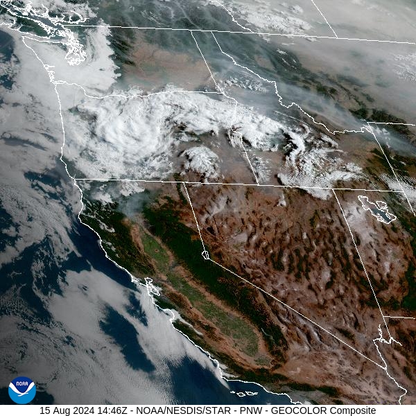
Source: NOAA
Forecast
Numerous wildfires continue to gradually expand across Idaho. These fires will send areas of light smoke into the Treasure State again on Thursday. A system will trigger scattered showers and thunderstorms once again on Thursday. Heavy rain, frequent lightning, and gusty winds will be the main threats from these storms. Outflow winds from these storms could create erratic fire behavior on existing wildfires.
Smoke models continue to advertise a weak cool front sliding south out of Canada Thursday and Friday. Wildfire smoke from Canadian fires will sag south, impacting much of northern and northeast Montana.
Scattered showers and storms will remain a possibility Friday and into the weekend. A southwesterly flow will send plumes of smoke from fires burning in Oregon and Idaho into Montana. A trough will move inland from the Pacific coast. There is still quite a bit of disagreement amongst the models as to how far east the trough will get. The further east it gets, the cooler it will be across Montana, with better chances of precipitation. Stay tuned!
By late Friday, the HRRR smoke model shows light smoke from Canadian wildfires drifting south into the state.
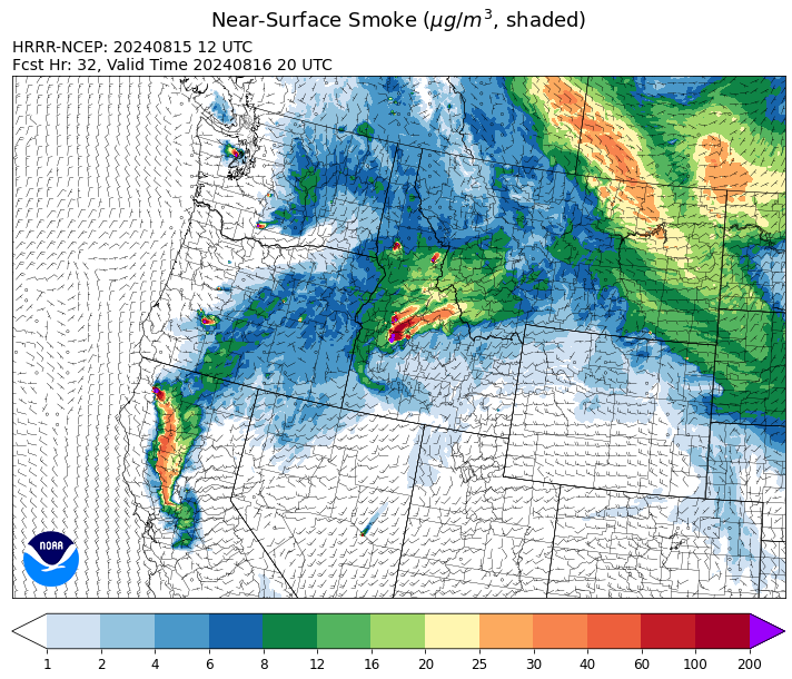
Source: HRRR Smoke
Conditions can change quickly as weather could stimulate active fires and the likelihood of new starts increases. Please keep track of concentrations at todaysair.mtdeq.us or the Fire and Smoke Map.
Current Wildfires
|
Incident |
State |
location |
acres |
containment |
|
Goat Fire - IDBOF |
Idaho |
11 miles SE of Cascade, Idaho |
981 |
0% |
|
Dollar Fire - IDBOF |
Idaho |
18 mi. NE of Cascade, Idaho |
1,666 |
0% |
|
Snag Fire - IDBOF |
Idaho |
9.5 miles East of Cascade, Idaho |
19,563 |
0% |
|
Boulder Fire - IDBOF |
Idaho |
9 Miles southwest of Cascade, Idaho. |
1,948 |
9% |
|
Wolf Creek Fire - IDPAF |
Idaho |
5 miles west of Donnelly, ID |
1,154 |
71% |
|
Middle Fork Complex Fire: Bulldog, Nellie, Anderson - IDBOF |
Idaho |
9 miles east of Garden Valley, ID |
8,308 |
0% |
|
Limepoint Fire - IDPAF |
Idaho |
8 miles NE of Oxbow Dam |
31,397 |
42% |
|
Cliff Mountain - IDPAF |
Idaho |
25 Miles East of Joseph, Oregon |
1,108 |
75% |
|
Paddock - IDBOD |
Idaho |
20 miles north of Emmett, Idaho |
187,185 |
77% |
|
Wapiti Fire - IDBOF |
Idaho |
2 miles southwest of Grandjean, ID |
3,646 |
0% |
|
Bulltrout Fire - IDBOF |
Idaho |
15 miles WNW OF Stanley, ID |
271 |
92% |
|
Bluff Creek Complex - IDIPF |
Idaho |
The fires are burning along both sides of the Bluff Ridge, approximately 13 1/2 miles southeast of Avery, ID; five and a half miles west from Gold Creek Campground; and approximately two miles northwest of Junction Ridge. |
432 |
NA |
|
Cracker Jack Complex - IDNCF |
Idaho |
All four fires are located within half a mile of each other: two and a half miles east of Concord, ID, less than a quarter acre east from Square Lake and less than a quarter acre west from Fish Lake. |
89 |
NA |
|
Farrow Fire - IDPAF |
Idaho |
NA |
396 |
NA |
|
Monumental Fire - IDPAF |
Idaho |
NA |
11 |
NA |
|
Wye Fire - IDNCF |
Idaho |
Approximately four and a half miles northwest of Freeman Peak and seven miles northeast of the Moose Creek Airstrip |
4,451 |
NA |
|
Ace Butte Fire - IDNCF |
Idaho |
Approximately 30 miles Southeast of Grangeville, Idaho |
64 |
NA |
|
Anchor Fire - IDNCF |
Idaho |
About half way between Hanover Mountain and Square Mountain in the Gospel Hump Wilderness |
72 |
NA |
|
Shepp Fire - IDNCF |
Idaho |
Approximately 30 miles Southwest of Elk City, Idaho |
100 |
NA |
|
Bench Lake Fire - IDSTF |
Idaho |
8 miles south of Stanley, Idaho |
2,595 |
90% |
|
Miller Peak Fire - MTLNF |
Montana |
7 miles southeast of Missoula |
2,724 |
86% |
|
Grouse - MTBDF |
Montana |
Ten miles southwest of Wise River, MT |
4,166 |
22% |
|
Black Canyon Fire - MTMTS |
Montana |
30 Miles NW of White Sulphur Springs, MT |
233 |
20% |
|
Johnson Fire - MTBRF |
Montana |
3 miles west of the Springer Memorial Community in the East Fork on the Bitterroot NF |
270 |
0% |
|
Elkhorn Ridge - MTBRF |
Montana |
West Fork District |
2,482 |
0% |
|
Black Mountain - MTHLF |
Montana |
6 miles northwest of Lincoln. Mont. |
182 |
87% |
|
Pentagon Fire - MTFNF |
Montana |
45 miles SE of Bigfork, MT |
62 |
0% |
|
Dixon Fire - ORUPF |
Oregon |
Tiller, Oregon |
1,997 |
4% |
|
Cottage Grove - Lane 1 - OR77S |
Oregon |
Approximately 16 miles SE of Springfield, OR |
24,103 |
31% |
|
Middle Fork Fire - ORCLP |
Oregon |
Middle Fork area, west of Crater Lake, Crater Lake National Park |
5,075 |
0% |
|
Diamond Complex - ORUPF |
Oregon |
18 miles southwest of Chemult, Oregon |
9,663 |
29% |
|
Telephone Fire - ORMAF |
Oregon |
16 miles north east of Burns, Oregon |
53,999 |
65% |
|
Falls Fire - ORMAF |
Oregon |
20 miles NW of Burns |
151,666 |
89% |
|
Red Fire - ORDEF |
Oregon |
Diamond Peak Wilderness |
659 |
0% |
|
Homestead Complex - ORUPF |
Oregon |
Thirty miles northeast of Glide Oregon |
4,387 |
14% |
|
Town Gulch - ORWWF |
Oregon |
Eagle Creek Rd Area, 24 Miles East of Baker City OR, 8 Miles N of Richland, OR |
18,188 |
62% |
|
Battle Mountain Complex - OR97S |
Oregon |
West and south of Ukiah, OR |
182,951 |
90% |
|
Willamette Complex Fires - South - ORWIF |
Oregon |
Willamette Complex fires are to the north and south of Oakridge. |
12,668 |
48% |
|
North Willamette Complex - ORWIF |
Oregon |
Willamette National Forest |
4,187 |
NA |
|
Whisky Creek Fire - ORMHF |
Oregon |
East fork of Herman Creek, 6 miles SE of Cascade Locks, OR |
1,905 |
7% |
|
Sandstone Fire - ORMHF |
Oregon |
9 miles SW of Ripplebrook, OR, on the Mt. Hood National Forest |
671 |
0% |
|
Warner Peak Fire - ORSHR |
Oregon |
3 miles East of Plush, on the Hart Mountain Antelope Refuge |
65,002 |
40% |
|
Courtrock Fire - OR95S |
Oregon |
7.1 Miles south of Monument, OR |
20,019 |
99% |
|
Crazy Creek - OROCF |
Oregon |
Crazy Creek:16 miles north of Paulina, OR |
86,603 |
63% |
|
Porcupine Fire - ORBUD |
Oregon |
Porcupine Reservoir |
6,491 |
95% |
|
Lone Rock Fire - ORPRD |
Oregon |
Lonerock stretching to west of HWY 207 and south to HWY 19 |
137,222 |
98% |
|
Badland Complex 2024 - ORVAD |
Oregon |
Baker County, Oregon |
54,563 |
99% |
|
Microwave Tower Fire - OR95S |
Oregon |
1 mile WSW of Mosier, OR |
1,313 |
95% |
|
Winding Waters Complex - OR97S |
Oregon |
23 miles east of Union, OR |
752 |
83% |
|
Ruby Fire - WANCP |
Washington |
On Ruby Mountain in North Cascade National Park by Diablo and Ross Lake, 9 miles East of Newhalem |
739 |
0% |
|
Kachess Complex - WAOWF |
Washington |
12 miles west of Cle Elum drainage |
21 |
NA |
|
Cougar Creek Fire - WASES |
Washington |
1 mile west of Hwy 129 and Grand Ronde river intersection |
24,091 |
60% |
|
Williams Mine Fire-GPNF - WAGPF |
Washington |
3.5 miles NNW of Trout Lake WA |
11,149 |
2% |
|
Easy Fire - WAOWF |
Washington |
North Cascades Hwy 20 Corridor, 17 air miles west of Mazama, WA |
2,130 |
29% |
|
Lodgepole - WAOWF |
Washington |
16 miles west of Cliffdell, WA |
35 |
0% |
|
Retreat - WASES |
Washington |
14 miles WSE of Naches, WA |
45,601 |
70% |
|
Pioneer - WASES |
Washington |
Approximate start 10 miles southeast of Stehekin, WA |
38,708 |
18% |
|
Pincer Two Fire - WAMSF |
Washington |
Johannesburg Mountain. 1 Mile East of Mineral Park C.G. |
189 |
0% |
Source: Inciweb
Tags: Smoke Forecast 2024