
Smoke Forecast for Wednesday, August 14, 2024 9:30 AM
Current Conditions
Low pressure continues to slowly pull away from Montana on Wednesday. A few showers and storms are possible as this feature exits the area. Much of the smoke around the state on Wednesday is the result of wildfires burning in Oregon and Idaho.
If you are experiencing issues accessing Today's Air, clear the cache in your browser and try again in a new tab.
The Grouse fire burning in the Pioneer Mountains southwest of Wise River remains the wildfire of greatest concern in the state. It has grown to 4,166 acres with 22% of the fire contained. A crew of 212 people are assigned to the Grouse fire.
At 9:00 AM Tuesday, Columbia Falls, Thompson Falls, Missoula, Cut Bank, Great Falls, Dillon, Lewistown, Malta, and Havre were enduring Moderate air quality.
Wednesday morning’s satellite shows a trough exiting the state providing clouds and showers. Light smoke is visible across Montana from regional wildfires.
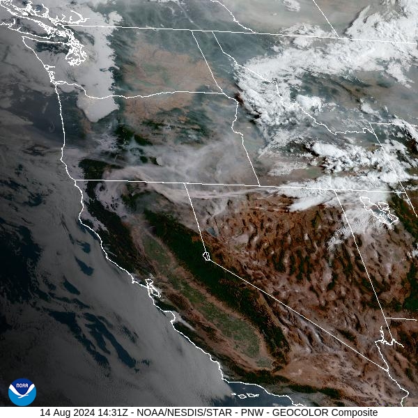
Source: NOAA
Forecast
Low pressure gradually pulls away from the Northern Rockies on Wednesday. A few showers and storms are possible once again, but precipitation won’t be nearly as widespread as it was the day prior. The precipitation should fizzle after sunset. Temperatures on Wednesday should be slightly cooler than Tuesday.
Numerous large fires continue to burn in Idaho. Thanks to a westerly flow, smoke from these fires will drift into the Treasure State. A weak cool front will slide south out of Canada on Thursday, as the flow becomes more northerly. This will send plumes of smoke from wildfires burning in Canada south into Montana.
High pressure builds over the region starting Saturday as a powerful low spins off the Pacific coast. This will result in a southwesterly flow across Montana, with smoke from upstream fires in Idaho and Oregon drifting into the area. High pressure will lead to the usual diurnal fluctuations in smoke. Expect to see smoke draining and pooling into the valleys overnight, leading to deteriorating air quality. In the afternoon, once the inversion breaks up, dispersion will increase and much of the smoke will be pushed away from the surface.
By late Thursday, the HRRR smoke model shows light smoke from Canadian wildfires drifting south into the state.
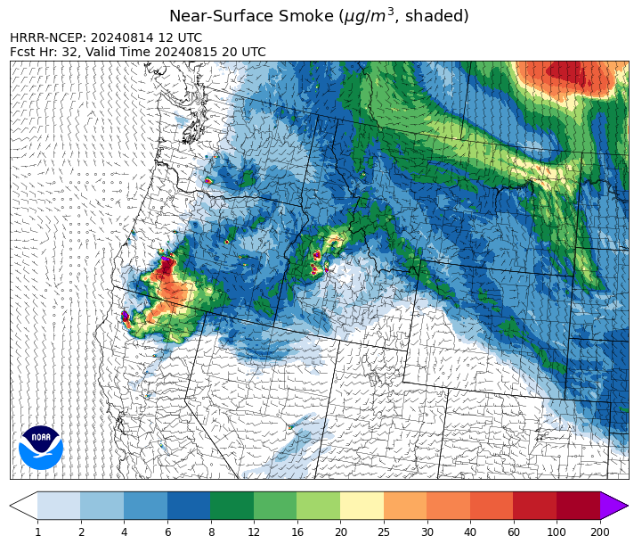
Source: HRRR Smoke
Conditions can change quickly as weather could stimulate active fires and the likelihood of new starts increases. Please keep track of concentrations at todaysair.mtdeq.us or the Fire and Smoke Map.
Current Wildfires
|
Incident |
State |
location |
acres |
containment |
|
Wapiti Fire - IDBOF |
Idaho |
2 miles southwest of Grandjean, ID |
3,104 |
0% |
|
Bulltrout Fire - IDBOF |
Idaho |
15 miles WNW OF Stanley, ID |
271 |
92% |
|
Middle Fork Complex Fire: Bulldog, Nellie, Anderson - IDBOF |
Idaho |
9 miles east of Garden Valley, ID |
7,701 |
0% |
|
Limepoint Fire - IDPAF |
Idaho |
8 miles NE of Oxbow Dam |
31,256 |
38% |
|
Cliff Mountain - IDPAF |
Idaho |
25 Miles East of Joseph, Oregon |
1,108 |
20% |
|
Paddock - IDBOD |
Idaho |
20 miles north of Emmett, Idaho |
187,185 |
60% |
|
Wolf Creek Fire - IDPAF |
Idaho |
5 miles west of Donnelly, ID |
1,154 |
61% |
|
Snag Fire - IDBOF |
Idaho |
9.5 miles East of Cascade, Idaho |
17,118 |
0% |
|
Goat Fire - IDBOF |
Idaho |
11 miles SE of Cascade, Idaho |
683 |
0% |
|
Dollar Fire - IDBOF |
Idaho |
18 mi. NE of Cascade, Idaho |
1,580 |
0% |
|
Boulder Fire - IDBOF |
Idaho |
9 Miles southwest of Cascade, Idaho. |
1,908 |
7% |
|
Farrow Fire - IDPAF |
Idaho |
NA |
396 |
NA |
|
Monumental Fire - IDPAF |
Idaho |
NA |
11 |
NA |
|
Wye Fire - IDNCF |
Idaho |
Approximately four and a half miles northwest of Freeman Peak and seven miles northeast of the Moose Creek Airstrip |
4,451 |
NA |
|
Bluff Creek Complex - IDIPF |
Idaho |
The fires are burning along both sides of the Bluff Ridge, approximately 13 1/2 miles southeast of Avery, ID; five and a half miles west from Gold Creek Campground; and approximately two miles northwest of Junction Ridge. |
432 |
NA |
|
Square Lake Fire - IDNCF |
Idaho |
All four fires are located within half a mile of each other: two and a half miles east of Concord, ID, less than a quarter acre east from Square Lake and less than a quarter acre west from Fish Lake. |
30 |
NA |
|
Ace Butte Fire - IDNCF |
Idaho |
Approximately 30 miles Southeast of Grangeville, Idaho |
64 |
NA |
|
Anchor Fire - IDNCF |
Idaho |
About half way between Hanover Mountain and Square Mountain in the Gospel Hump Wilderness |
72 |
NA |
|
Shepp Fire - IDNCF |
Idaho |
Approximately 30 miles Southwest of Elk City, Idaho |
100 |
NA |
|
Bench Lake Fire - IDSTF |
Idaho |
8 miles south of Stanley, Idaho |
2,595 |
90% |
|
Miller Peak Fire - MTLNF |
Montana |
7 miles southeast of Missoula |
2,724 |
86% |
|
Black Canyon Fire - MTMTS |
Montana |
31 Miles Southeast of Cascade, MT |
270 |
5% |
|
Grouse - MTBDF |
Montana |
Ten miles southwest of Wise River, MT |
4,166 |
22% |
|
Johnson Fire - MTBRF |
Montana |
3 miles west of the Springer Memorial Community in the East Fork on the Bitterroot NF |
270 |
0% |
|
Elkhorn Ridge - MTBRF |
Montana |
West Fork District |
2,482 |
0% |
|
Pentagon Fire - MTFNF |
Montana |
45 miles SE of Bigfork, MT |
62 |
0% |
|
Black Mountain - MTHLF |
Montana |
6 miles northwest of Lincoln. Mont. |
182 |
87% |
|
Warner Peak Fire - ORSHR |
Oregon |
3 miles East of Plush, on the Hart Mountain Antelope Refuge |
61,330 |
19% |
|
Crazy Creek - OROCF |
Oregon |
Crazy Creek:16 miles north of Paulina, OR |
86,603 |
63% |
|
Cottage Grove - Lane 1 - OR77S |
Oregon |
Approximately 16 miles SE of Springfield, OR |
23,451 |
26% |
|
North Willamette Complex - ORWIF |
Oregon |
Willamette National Forest |
4,024 |
NA |
|
Telephone Fire - ORMAF |
Oregon |
16 miles north east of Burns, Oregon |
53,999 |
65% |
|
Falls Fire - ORMAF |
Oregon |
20 miles NW of Burns |
151,666 |
89% |
|
Dixon Fire - ORUPF |
Oregon |
Tiller, Oregon |
1,997 |
0% |
|
Diamond Complex - ORUPF |
Oregon |
18 miles southwest of Chemult, Oregon |
8,885 |
29% |
|
Homestead Complex - ORUPF |
Oregon |
Thirty miles northeast of Glide Oregon |
4,387 |
14% |
|
Middle Fork Fire - ORCLP |
Oregon |
Middle Fork area, west of Crater Lake, Crater Lake National Park |
4,929 |
0% |
|
Town Gulch - ORWWF |
Oregon |
Eagle Creek Rd Area, 24 Miles East of Baker City OR, 8 Miles N of Richland, OR |
18,188 |
42% |
|
Red Fire - ORDEF |
Oregon |
Diamond Peak Wilderness |
659 |
0% |
|
Battle Mountain Complex - OR97S |
Oregon |
West and south of Ukiah, OR |
182,870 |
87% |
|
Sandstone Fire - ORMHF |
Oregon |
9 miles SW of Ripplebrook, OR, on the Mt. Hood National Forest |
625 |
0% |
|
Whisky Creek Fire - ORMHF |
Oregon |
East fork of Herman Creek, 6 miles SE of Cascade Locks, OR |
1,903 |
0% |
|
Courtrock Fire - OR95S |
Oregon |
7.1 Miles south of Monument, OR |
20,019 |
99% |
|
Willamette Complex Fires - South - ORWIF |
Oregon |
Willamette Complex fires are to the north and south of Oakridge. |
12,537 |
38% |
|
Porcupine Fire - ORBUD |
Oregon |
Porcupine Reservoir |
6,491 |
95% |
|
Lone Rock Fire - ORPRD |
Oregon |
Lonerock stretching to west of HWY 207 and south to HWY 19 |
137,222 |
98% |
|
Badland Complex 2024 - ORVAD |
Oregon |
Baker County, Oregon |
54,563 |
99% |
|
Microwave Tower Fire - OR95S |
Oregon |
1 mile WSW of Mosier, OR |
1,313 |
95% |
|
Winding Waters Complex - OR97S |
Oregon |
23 miles east of Union, OR |
752 |
83% |
|
Durkee Fire - ORVAD |
Oregon |
1 mile west of Durkee, Oregon |
294,265 |
95% |
|
Easy Fire - WAOWF |
Washington |
North Cascades Hwy 20 Corridor, 17 air miles west of Mazama, WA |
2,130 |
0% |
|
Pioneer - WASES |
Washington |
Approximate start 10 miles southeast of Stehekin, WA |
38,420 |
13% |
|
Ruby Fire - WANCP |
Washington |
On Ruby Mountain in North Cascade National Park by Diablo and Ross Lake, 9 miles East of Newhalem |
739 |
0% |
|
Williams Mine Fire-GPNF - WAGPF |
Washington |
3.5 miles NNW of Trout Lake WA |
10,968 |
0% |
|
Cougar Creek Fire - WASES |
Washington |
1 mile west of Hwy 129 and Grand Ronde river intersection |
24,091 |
60% |
|
Retreat - WASES |
Washington |
14 miles WSE of Naches, WA |
45,601 |
70% |
|
Lodgepole - WAOWF |
Washington |
16 miles west of Cliffdell, WA |
5 |
0% |
|
Pincer Two Fire - WAMSF |
Washington |
Johannesburg Mountain. 1 Mile East of Mineral Park C.G. |
189 |
0% |
Source: Inciweb
Tags: Smoke Forecast 2024