
Smoke Forecast for Tuesday, August 13, 2024 10:00 AM
Current Conditions
A broad trough remains over Montana again on Tuesday. A disturbance rotating around this trough moves into Montana bringing another round of scattered showers and thunderstorms by Tuesday afternoon. A southwesterly flow will continue to pump smoke into the state from wildfires burning to our south and west.
If you are experiencing issues accessing Today's Air, clear the cache in your browser and try again in a new tab.
The Grouse fire burning in the Pioneer Mountains southwest of Wise River remains the wildfire of greatest concern in the state. It has grown to 4,166 acres with 22% of the fire contained. A crew of 288 people are assigned to the Grouse fire.
At 9:00 AM Tuesday, Libby, Thompson Falls, Seeley Lake, Frenchtown, Missoula, Hamilton, Columbia Falls, Cut Bank, Choteau, Great Falls, Lewistown, and Sleeping Giant were enduring Moderate air quality.
Tuesday morning’s satellite shows a trough swinging across Montana providing clouds and light smoke for the area.
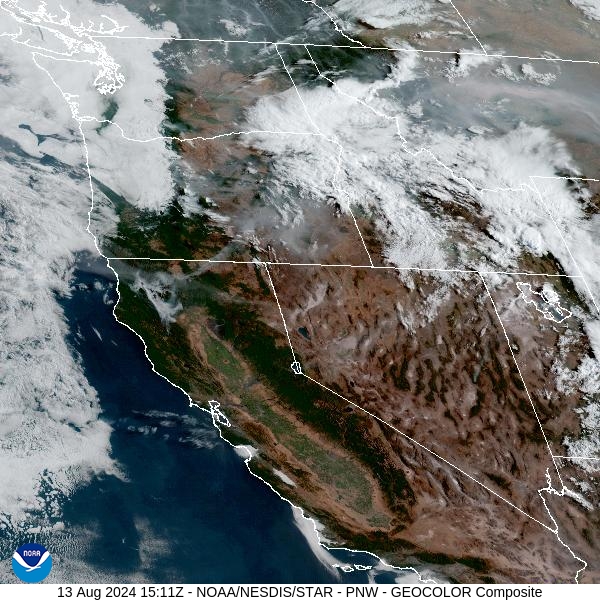
Source: NOAA
Forecast
Another disturbance rotating around a trough of low pressure will provide chances for rain and thunderstorms again on Tuesday. Some of the stronger storms will generate heavy rain, frequent lightning, and gusty winds. There is some concern for rapid runoff and even debris flows over burn scars like the Horse Gulch burn. Strong outflow winds will create erratic fire behavior on ongoing wildfires.
High pressure builds across Montana on Wednesday. It will reduce the threat of showers and thunderstorms. Expect the usual diurnal fluctuations in smoke under this pattern. Smoke will tend to drain and pool into the valleys overnight, with better dispersion and air quality by the afternoon.
A southwesterly flow will persist for the next several days. This will tend to bring smoke from surrounding states into the Northern Rockies and Montana. However, near daily chances for precipitation will continue through the end of the week and into the weekend. This will help to moderate fire behavior and limit smoke production on existing fires.
By late Wednesday, the HRRR smoke model shows light smoke covering much of the state, with higher concentrations of smoke over Southwest Montana.
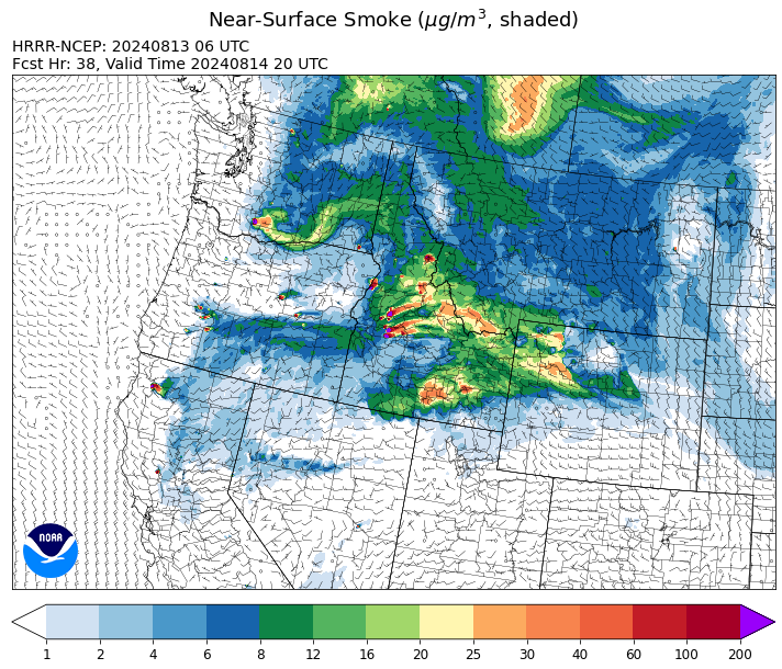
Source: HRRR Smoke
Conditions can change quickly as weather could stimulate active fires and the likelihood of new starts increases. Please keep track of concentrations at todaysair.mtdeq.us or the Fire and Smoke Map.
Current Wildfires
|
Incident |
State |
location |
acres |
containment |
|
Goat Fire - IDBOF |
Idaho |
11 miles SE of Cascade, Idaho |
385 |
0% |
|
Limepoint Fire - IDPAF |
Idaho |
8 miles NE of Oxbow Dam |
31,256 |
27% |
|
Dollar Fire - IDBOF |
Idaho |
18 mi. NE of Cascade, Idaho |
1,376 |
0% |
|
Bulltrout Fire - IDBOF |
Idaho |
15 miles WNW OF Stanley, ID |
271 |
92% |
|
Wapiti Fire - IDBOF |
Idaho |
2 miles southwest of Grandjean, ID |
2,667 |
0% |
|
Middle Fork Complex Fire: Bulldog, Nellie, Anderson - IDBOF |
Idaho |
9 miles east of Garden Valley, ID |
5,781 |
1% |
|
Snag Fire - IDBOF |
Idaho |
9.5 miles East of Cascade, Idaho |
17,118 |
0% |
|
Paddock - IDBOD |
Idaho |
20 miles north of Emmett, Idaho |
187,185 |
31% |
|
Boulder Fire - IDBOF |
Idaho |
9 Miles southwest of Cascade, Idaho. |
1,795 |
6% |
|
Wolf Creek Fire - IDPAF |
Idaho |
5 miles west of Donnelly, ID |
1,154 |
55% |
|
Cliff Mountain - IDPAF |
Idaho |
25 Miles East of Joseph, Oregon |
1,108 |
20% |
|
Bluff Creek Complex - IDIPF |
Idaho |
The fires are burning along both sides of the Bluff Ridge, approximately 13 1/2 miles southeast of Avery, ID; five and a half miles west from Gold Creek Campground; and approximately two miles northwest of Junction Ridge. |
432 |
NA |
|
Square Lake Fire - IDNCF |
Idaho |
All four fires are located within half a mile of each other: two and a half miles east of Concord, ID, less than a quarter acre east from Square Lake and less than a quarter acre west from Fish Lake. |
30 |
NA |
|
Ace Butte Fire - IDNCF |
Idaho |
Approximately 30 miles Southeast of Grangeville, Idaho |
64 |
NA |
|
Anchor Fire - IDNCF |
Idaho |
About half way between Hanover Mountain and Square Mountain in the Gospel Hump Wilderness |
72 |
NA |
|
Wye Fire - IDNCF |
Idaho |
Approximately four and a half miles northwest of Freeman Peak and seven miles northeast of the Moose Creek Airstrip |
3,760 |
NA |
|
Farrow Fire - IDPAF |
Idaho |
NA |
300 |
NA |
|
Monumental Fire - IDPAF |
Idaho |
NA |
7 |
NA |
|
Shepp Fire - IDNCF |
Idaho |
Approximately 30 miles Southwest of Elk City, Idaho |
100 |
NA |
|
Bench Lake Fire - IDSTF |
Idaho |
8 miles south of Stanley, Idaho |
2,595 |
90% |
|
Black Canyon Fire - MTMTS |
Montana |
31 Miles Southeast of Cascade, MT |
270 |
5% |
|
Grouse - MTBDF |
Montana |
Ten miles southwest of Wise River, MT |
4,157 |
22% |
|
Miller Peak Fire - MTLNF |
Montana |
7 miles southeast of Missoula |
2,724 |
86% |
|
Elkhorn Ridge - MTBRF |
Montana |
West Fork District |
2,482 |
0% |
|
Johnson Fire - MTBRF |
Montana |
3 miles west of the Springer Memorial Community in the East Fork on the Bitterroot NF |
270 |
0% |
|
Pentagon Fire - MTFNF |
Montana |
45 miles SE of Bigfork, MT |
62 |
0% |
|
Black Mountain - MTHLF |
Montana |
6 miles northwest of Lincoln. Mont. |
182 |
87% |
|
Falls Fire - ORMAF |
Oregon |
20 miles NW of Burns |
150,941 |
87% |
|
North Willamette Complex - ORWIF |
Oregon |
Willamette National Forest |
4,024 |
NA |
|
Dixon Fire - ORUPF |
Oregon |
Tiller, Oregon |
1,997 |
0% |
|
Cottage Grove - Lane 1 - OR77S |
Oregon |
Approximately 16 miles SE of Springfield, OR |
22,998 |
21% |
|
Warner Peak - ORSHR |
Oregon |
3 miles East of Plush, on the Hart Mountain Antelope Refuge |
59,170 |
4% |
|
Warner Peak - ORSHR |
Oregon |
3 miles East of Plush, on the Hart Mountain Antelope Refuge |
59,170 |
4% |
|
Telephone Fire - ORMAF |
Oregon |
16 miles north east of Burns, Oregon |
53,989 |
64% |
|
Sandstone Fire - ORMHF |
Oregon |
9 miles SW of Ripplebrook, OR, on the Mt. Hood National Forest |
625 |
0% |
|
Town Gulch - ORWWF |
Oregon |
Eagle Creek Rd Area, 24 Miles East of Baker City OR, 8 Miles N of Richland, OR |
18,183 |
42% |
|
Homestead Complex - ORUPF |
Oregon |
Thirty miles northeast of Glide Oregon |
4,151 |
14% |
|
Diamond Complex - ORUPF |
Oregon |
18 miles southwest of Chemult, Oregon |
8,466 |
20% |
|
Middle Fork Fire - ORCLP |
Oregon |
Middle Fork area, west of Crater Lake, Crater Lake National Park |
4,929 |
0% |
|
Battle Mountain Complex - OR97S |
Oregon |
West and south of Ukiah, OR |
182,863 |
82% |
|
Red Fire - ORDEF |
Oregon |
Diamond Peak Wilderness |
585 |
0% |
|
Whisky Creek Fire - ORMHF |
Oregon |
East fork of Herman Creek, 6 miles SE of Cascade Locks, OR |
1,865 |
0% |
|
Ore Fire - ORWIF |
Oregon |
7 Miles NE of Blue River, OR |
NA |
NA |
|
Willamette Complex Fires - South - ORWIF |
Oregon |
Willamette Complex fires are to the north and south of Oakridge. |
11,875 |
38% |
|
Porcupine Fire - ORBUD |
Oregon |
Porcupine Reservoir |
6,491 |
95% |
|
Crazy Creek - OROCF |
Oregon |
Crazy Creek:16 miles north of Paulina, OR |
84,512 |
60% |
|
Courtrock Fire - OR95S |
Oregon |
7.1 Miles south of Monument, OR |
20,019 |
97% |
|
Lone Rock Fire - ORPRD |
Oregon |
Lonerock stretching to west of HWY 207 and south to HWY 19 |
137,222 |
98% |
|
Badland Complex 2024 - ORVAD |
Oregon |
Baker County, Oregon |
54,563 |
99% |
|
Microwave Tower Fire - OR95S |
Oregon |
1 mile WSW of Mosier, OR |
1,313 |
95% |
|
Winding Waters Complex - OR97S |
Oregon |
23 miles east of Union, OR |
752 |
83% |
|
Durkee Fire - ORVAD |
Oregon |
1 mile west of Durkee, Oregon |
294,265 |
95% |
|
Cougar Creek Fire - WASES |
Washington |
1 mile west of Hwy 129 and Grand Ronde river intersection |
24,096 |
60% |
|
Ruby Fire - WANCP |
Washington |
On Ruby Mountain in North Cascade National Park by Diablo and Ross Lake, 9 miles East of Newhalem |
739 |
0% |
|
Easy Fire - WAOWF |
Washington |
North Cascades Hwy 20 Corridor, 17 air miles west of Mazama, WA |
2,130 |
0% |
|
Pioneer - WASES |
Washington |
Approximate start 10 miles southeast of Stehekin, WA |
38,420 |
13% |
|
Williams Mine Fire-GPNF - WAGPF |
Washington |
3.5 miles NNW of Trout Lake WA |
10,584 |
0% |
|
Retreat - WASES |
Washington |
14 miles WSE of Naches, WA |
45,601 |
70% |
|
Pincer Two Fire - WAMSF |
Washington |
Johannesburg Mountain. 1 Mile East of Mineral Park C.G. |
189 |
0% |
|
Lower Granite Fire - WANES |
Washington |
Northeast of Pomeroy, WA |
14,482 |
100% |
Source: Inciweb
Tags: Smoke Forecast 2024