
Smoke Forecast for Friday, August 9, 2024 9:30 AM
Current Conditions
Clouds and continued cooler air kept Montana’s wildfires under control again on Thursday. Oregon, Washington, and Idaho largely missed out on the cooler air and clouds, so fire behavior in these states has remained active.
The Grouse fire burning in the Pioneer Mountains southwest of Wise River remains the wildfire of greatest concern in the state. It has grown to 3,720 acres with only 5% of the fire contained. The National Weather Service is sending an incident meteorologist to the Grouse fire to help keep fire crews safe.
At 9:00 AM Thursday, Libby, Thompson Falls, Frenchtown, Great Falls, Cut Bank, Helena, Sleeping Giant, Missoula, Hamilton, Seeley Lake, Lewistown, Columbia Falls, Billings, Broadus, West Yellowstone, Miles City, and Bozeman were enduring Moderate air quality.
DEQ’s Today’s Air website is scheduled for maintenance 3pm Friday, August 9th through Sunday, August 11th. During this time please find Montana air quality information through the Fire and Smoke Map (airnow.gov)
Friday morning’s satellite shows widespread light smoke covering the western half of Montana.
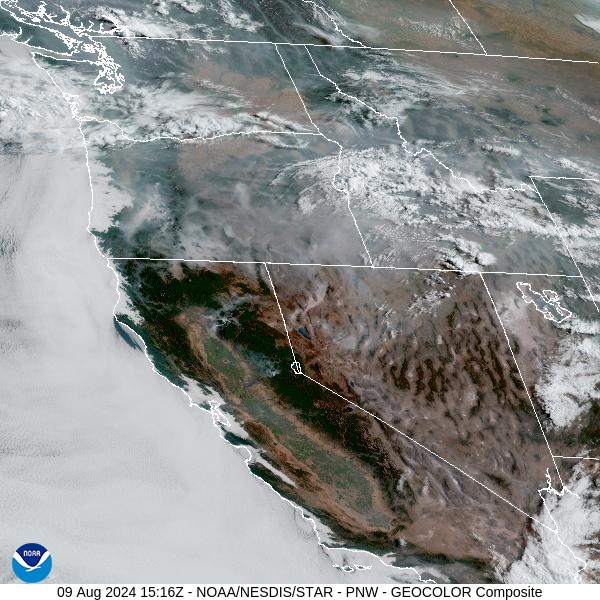
Source: NOAA
Forecast
A southwesterly flow will bring impulses of energy into Montana and the Northern Rockies on Friday. It will provide chances for showers and thunderstorms, primarily along and south of I-90. The southwest wind will also begin to move smoke from fires burning in Idaho and Oregon into portions of Southwest Montana. Idaho and Oregon have several large wildfires burning, and they largely missed out on the precipitation earlier in the week that fell across Montana.
A stronger system is expected to move across the Treasure State on Saturday. It will bring more widespread precipitation to the area, particularly west of the Continental Divide. A few of the stronger storms will be capable of generating gusty outflow winds, which could produce erratic fire behavior on existing blazes. Another round of showers and storms is expected over the region by Sunday afternoon and evening.
A ridge of high pressure will build over Montana by early next week. It is expected to bring warmer and drier weather to the Northern Rockies. The pattern will allow existing wildfire to expand. It will bring the usual diurnal fluctuations in air quality, with draining and pooling of the smoke at night leading to deteriorating air quality. By afternoon, the atmosphere becomes better mixed, allowing much of the surface smoke to move out as winds increase. However, this ridge won’t be nearly as strong as the prior one, so record heat is unlikely.
By late Saturday, the HRRR smoke model shows smoke from wildfires burning in Idaho, Washington, and Oregon drifting into Southwest Montana.
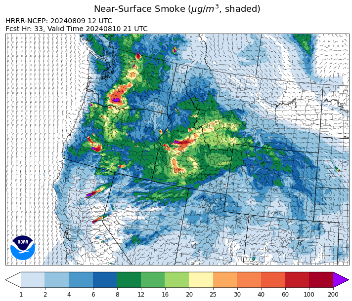
Source: HRRR Smoke
Conditions can change quickly as weather could stimulate active fires and the likelihood of new starts increases. Please keep track of concentrations at todaysair.mtdeq.us or the Fire and Smoke Map.
Current Wildfires
|
Incident |
State |
location |
acres |
containment |
|
Limepoint Fire - IDPAF |
Idaho |
8 miles NE of Oxbow Dam |
26,795 |
27% |
|
Bulltrout Fire - IDBOF |
Idaho |
15 miles WNW OF Stanley, ID |
271 |
74% |
|
Wapiti Fire - IDBOF |
Idaho |
2 miles southwest of Grandjean, ID |
1,705 |
0% |
|
Boulder Fire - IDBOF |
Idaho |
9 Miles southwest of Cascade, Idaho. |
1,493 |
6% |
|
Wolf Creek Fire - IDPAF |
Idaho |
5 miles west of Donnelly, ID |
1,054 |
46% |
|
Snag Fire - IDBOF |
Idaho |
9.5 miles East of Cascade, Idaho |
6,180 |
0% |
|
Dollar Fire - IDBOF |
Idaho |
18 mi. NE of Cascade, Idaho |
1,233 |
0% |
|
Cliff Mountain - IDPAF |
Idaho |
25 Miles East of Joseph, Oregon |
1,108 |
20% |
|
Paddock - IDBOD |
Idaho |
20 miles north of Emmett, Idaho |
153,237 |
0% |
|
Farrow Fire - IDPAF |
Idaho |
NA |
300 |
NA |
|
Monumental Fire - IDPAF |
Idaho |
NA |
7 |
NA |
|
Shepp Fire - IDNCF |
Idaho |
Approximately 30 miles Southwest of Elk City, Idaho |
100 |
NA |
|
Bench Lake Fire - IDSTF |
Idaho |
8 miles south of Stanley, Idaho |
2,595 |
90% |
|
Anchor Fire - IDNCF |
Idaho |
About half way between Hanover Mountain and Square Mountain in the Gospel Hump Wilderness |
72 |
NA |
|
Ace Butte Fire - IDNCF |
Idaho |
Approximately 30 miles Southeast of Grangeville, Idaho |
64 |
NA |
|
Wye Fire - IDNCF |
Idaho |
Approximately four and a half miles northwest of Freeman Peak and seven miles northeast of the Moose Creek Airstrip |
3,760 |
NA |
|
Bluff Creek Complex - IDIPF |
Idaho |
The fires are burning along both sides of the Bluff Ridge, approximately 13 1/2 miles southeast of Avery, ID; five and a half miles west from Gold Creek Campground; and approximately two miles northwest of Junction Ridge. |
432 |
NA |
|
2024 Gwen Fire - IDIDS |
Idaho |
South of Juliaetta Idaho, about 30 miles outside Lewiston near State Highway 3 in Latah County |
28,820 |
90% |
|
Thunder Fire - IDSCF |
Idaho |
12 miles south, southwest of Salmon, ID |
2,474 |
90% |
|
Grouse - MTBDF |
Montana |
Ten miles southwest of Wise River, MT |
3,720 |
5% |
|
Black Mountain - MTHLF |
Montana |
6 miles northwest of Lincoln. Mont. |
182 |
87% |
|
Miller Peak Fire - MTLNF |
Montana |
7 miles southeast of Missoula |
2,724 |
86% |
|
Elkhorn Ridge - MTBRF |
Montana |
West Fork District |
500 |
0% |
|
Johnson Fire - MTBRF |
Montana |
3 miles west of the Springer Memorial Community in the East Fork on the Bitterroot NF |
270 |
0% |
|
Pentagon Fire - MTFNF |
Montana |
45 miles SE of Bigfork, MT |
62 |
0% |
|
Muir Creek Fire - MTGNP |
Montana |
20 miles southeast of West Glacier, MT and east of the Middle Fork of the Flathead River |
30 |
0% |
|
Courtrock Fire - OR95S |
Oregon |
7.1 Miles south of Monument, OR |
20,019 |
83% |
|
Lone Rock Fire - ORPRD |
Oregon |
Lonerock stretching to west of HWY 207 and south to HWY 19 |
137,222 |
98% |
|
Oakridge Lightning Fires 2024 - ORWIF |
Oregon |
Willamette Complex fires are to the north and south of Oakridge. |
NA |
38% |
|
Diamond Complex - ORUPF |
Oregon |
18 miles southwest of Chemult, Oregon |
7,629 |
11% |
|
Falls Fire - ORMAF |
Oregon |
20 miles NW of Burns |
147,789 |
77% |
|
Middle Fork Fire - ORCLP |
Oregon |
Middle Fork area, west of Crater Lake, Crater Lake National Park |
4,012 |
0% |
|
North Willamette Complex - ORWIF |
Oregon |
Willamette National Forest |
NA |
NA |
|
Red Fire - ORDEF |
Oregon |
Diamond Peak Wilderness |
530 |
0% |
|
Ore Fire - ORWIF |
Oregon |
7 Miles NE of Blue River, OR |
2,221 |
29% |
|
Homestead Complex - ORUPF |
Oregon |
Thirty miles northeast of Glide Oregon |
3,384 |
14% |
|
Battle Mountain Complex - OR97S |
Oregon |
West and south of Ukiah, OR |
182,766 |
61% |
|
Sandstone Fire - ORMHF |
Oregon |
9 miles SW of Ripplebrook, OR, on the Mt. Hood National Forest |
385 |
0% |
|
Microwave Tower Fire - OR95S |
Oregon |
1 mile WSW of Mosier, OR |
1,313 |
95% |
|
Cottage Grove - Lane 1 - OR77S |
Oregon |
Approximately 16 miles SE of Springfield, OR |
15,830 |
9% |
|
Whisky Creek Fire - ORMHF |
Oregon |
East fork of Herman Creek, 6 miles SE of Cascade Locks, OR |
1,447 |
0% |
|
Town Gulch - ORWWF |
Oregon |
Eagle Creek Rd Area, 24 Miles East of Baker City OR, 8 Miles N of Richland, OR |
18,500 |
0% |
|
Porcupine Fire - ORBUD |
Oregon |
Porcupine Reservoir |
6,553 |
11% |
|
Winding Waters Complex - OR97S |
Oregon |
23 miles east of Union, OR |
752 |
83% |
|
Telephone Fire - ORMAF |
Oregon |
16 miles north east of Burns, Oregon |
53,487 |
59% |
|
Crazy Creek - OROCF |
Oregon |
Crazy Creek:16 miles north of Paulina, OR |
78,495 |
28% |
|
Durkee Fire - ORVAD |
Oregon |
1 mile west of Durkee, Oregon |
294,265 |
95% |
|
Adam Mountain - ORUPF |
Oregon |
Approximately 6 miles southeast of Dorena, Oregon |
12,645 |
9% |
|
Badland Complex 2024 - ORVAD |
Oregon |
Baker County, Oregon |
54,563 |
99% |
|
Cougar Creek Fire - WASES |
Washington |
1 mile west of Hwy 129 and Grand Ronde river intersection |
20,999 |
35% |
|
Retreat - WASES |
Washington |
14 miles WSE of Naches, WA |
44,588 |
63% |
|
Pioneer - WASES |
Washington |
Approximate start 10 miles southeast of Stehekin, WA |
36,970 |
13% |
|
Easy Fire - WAOWF |
Washington |
North Cascades Hwy 20 Corridor, 17 air miles west of Mazama, WA |
1,754 |
0% |
|
Williams Mine Fire-GPNF - WAGPF |
Washington |
3.5 miles NNW of Trout Lake WA |
4,500 |
0% |
|
Pincer Two Fire - WAMSF |
Washington |
Johannesburg Mountain. 1 Mile East of Mineral Park C.G. |
115 |
0% |
Source: Inciweb
Tags: Smoke Forecast 2024