
Smoke Forecast for Thursday, August 8, 2024 9:30 AM
Current Conditions
Clouds and cooler air kept Montana’s wildfires in check on Wednesday. To our west, Oregon, Idaho, and Washington saw abundant sunshine and more seasonable temperatures on Wednesday, allowing many fires to expand.
The Grouse fire burning in the Pioneer Mountains southwest of Wise River remains the wildfire of greatest concern in the state. It has grown to 3,700 acres with only 5% of the fire contained.
At 9:00 AM Thursday, Libby, Thompson Falls, Frenchtown, Great Falls, Cut Bank, Havre, Malta, Billings, Broadus, Miles City, and Bozeman were enduring Moderate air quality.
DEQ’s Today’s Air website is scheduled for maintenance 3pm Friday, August 9th through Sunday, August 11th. During this time please find Montana air quality information through the Fire and Smoke Map.
Thursday morning’s satellite shows clouds and fog over Montana behind a departing area of low pressure.
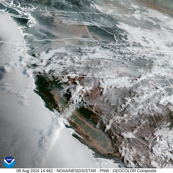
Source: NOAA
Forecast
Low pressure shifts east into the Dakotas on Thursday. This will provide an easterly flow and seasonably cool temperatures. Several large and active wildfires continue to burn in Oregon, Washington, and Idaho. The easterly flow should keep much of the smoke from these fires out of the Treasure State. Light plumes of smoke will impact the eastern half of the state from Canadian wildfires.
A broad trough shifts into the region on Friday. It will help to turn our flow aloft around to the southwest. This will provide a gradual warming trend for the Northern Rockies. It will also bring smoke from upstream wildfires into the state, particularly Southwest Montana. Air quality levels will likely deteriorate, especially for areas like Ravalli, Beaverhead, Granite, and Deer Lodge Counties.
A southwesterly flow will linger into the weekend as a broad trough remains in place. Impulses will rotate around the trough, bringing daily chances for afternoon and early evening precipitation. Temperatures should remain on the cool side compared to seasonal averages. The combination of clouds and cooler temperatures should help keep wildfire activity in check. However, the southwesterly flow will occasionally bring smoke from wildfires burning in Idaho, Washington, and Oregon into Montana.
By late Friday, the HRRR smoke model shows smoke from wildfires burning in Idaho, Washington, and Oregon drifting into Southwest Montana.
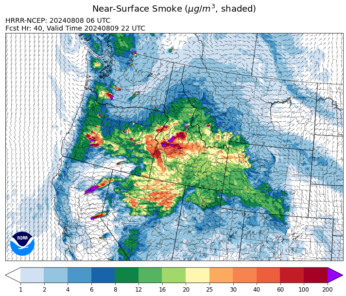
Source: HRRR Smoke
Conditions can change quickly as weather could stimulate active fires and the likelihood of new starts increases. Please keep track of concentrations at todaysair.mtdeq.us or the Fire and Smoke Map.
Current Wildfires
|
Incident |
State |
location |
acres |
containment |
|
Wapiti Fire - IDBOF |
Idaho |
2 miles southwest of Grandjean, ID |
740 |
0% |
|
Limepoint Fire - IDPAF |
Idaho |
8 miles NE of Oxbow Dam |
25,921 |
10% |
|
Bulltrout Fire - IDBOF |
Idaho |
15 miles WNW OF Stanley, ID |
271 |
65% |
|
Cliff Mountain - IDPAF |
Idaho |
25 Miles East of Joseph, Oregon |
1,108 |
20% |
|
Snag Fire - IDBOF |
Idaho |
9.5 miles East of Cascade, Idaho |
1,451 |
0% |
|
Dollar Fire - IDBOF |
Idaho |
18 mi. NE of Cascade, Idaho |
1,060 |
0% |
|
Paddock - IDBOD |
Idaho |
20 miles north of Emmett, Idaho |
118,000 |
5% |
|
Wolf Creek Fire - IDPAF |
Idaho |
5 miles west of Donnelly, ID |
1,149 |
21% |
|
Boulder Fire - IDBOF |
Idaho |
9 Miles southwest of Cascade, Idaho. |
1,023 |
6% |
|
Bench Lake Fire - IDSTF |
Idaho |
8 miles south of Stanley, Idaho |
2,595 |
90% |
|
Anchor Fire - IDNCF |
Idaho |
About halfway between Hanover Mountain and Square Mountain in the Gospel Hump Wilderness |
72 |
NA |
|
Ace Butte Fire - IDNCF |
Idaho |
Approximately 30 miles Southeast of Grangeville, Idaho |
64 |
NA |
|
Wye Fire - IDNCF |
Idaho |
Approximately four and a half miles northwest of Freeman Peak and seven miles northeast of the Moose Creek Airstrip |
3,760 |
NA |
|
Bluff Creek Complex - IDIPF |
Idaho |
The fires are burning along both sides of the Bluff Ridge, approximately 13 1/2 miles southeast of Avery, ID; five and a half miles west from Gold Creek Campground; and approximately two miles northwest of Junction Ridge. |
432 |
NA |
|
Shepp Fire - IDNCF |
Idaho |
Approximately 30 miles Southwest of Elk City, Idaho |
100 |
NA |
|
2024 Gwen Fire - IDIDS |
Idaho |
South of Juliaetta Idaho, about 30 miles outside Lewiston near State Highway 3 in Latah County |
28,820 |
90% |
|
Thunder Fire - IDSCF |
Idaho |
12 miles south, southwest of Salmon, ID |
2,474 |
75% |
|
Grouse - MTBDF |
Montana |
Ten miles southwest of Wise River, MT |
3,700 |
5% |
|
Johnson Fire - MTBRF |
Montana |
3 miles west of the Springer Memorial Community in the East Fork on the Bitterroot NF |
270 |
0% |
|
Miller Peak Fire - MTLNF |
Montana |
7 miles southeast of Missoula |
2,724 |
86% |
|
Black Mountain - MTHLF |
Montana |
6 miles northwest of Lincoln. Mont. |
182 |
67% |
|
Pentagon Fire - MTFNF |
Montana |
45 miles SE of Bigfork, MT |
62 |
0% |
|
Muir Creek Fire - MTGNP |
Montana |
20 miles southeast of West Glacier, MT and east of the Middle Fork of the Flathead River |
30 |
0% |
|
Courtrock Fire - OR95S |
Oregon |
7.1 Miles south of Monument, OR |
20,019 |
83% |
|
Telephone Fire - ORMAF |
Oregon |
16 miles north east of Burns, Oregon |
53,487 |
59% |
|
Falls Fire - ORMAF |
Oregon |
20 miles NW of Burns |
147,403 |
76% |
|
Lone Rock Fire - ORPRD |
Oregon |
Lonerock stretching to west of HWY 207 and south to HWY 19 |
137,222 |
92% |
|
Ore Fire - ORWIF |
Oregon |
7 Miles NE of Blue River, OR |
2,221 |
29% |
|
Oakridge Lightning Fires 2024 - ORWIF |
Oregon |
Willamette Complex fires are to the north and south of Oakridge. |
12,193 |
0% |
|
Whisky Creek Fire - ORMHF |
Oregon |
East fork of Herman Creek, 6 miles SE of Cascade Locks, OR |
1,447 |
0% |
|
Diamond Complex - ORUPF |
Oregon |
18 miles southwest of Chemult, Oregon |
7,624 |
11% |
|
Crazy Creek - OROCF |
Oregon |
Crazy Creek:16 miles north of Paulina, OR |
78,495 |
28% |
|
Battle Mountain Complex - OR97S |
Oregon |
West and south of Ukiah, OR |
182,604 |
48% |
|
Middle Fork Fire - ORCLP |
Oregon |
Middle Fork area, west of Crater Lake, Crater Lake National Park |
2,527 |
1% |
|
Sandstone Fire - ORMHF |
Oregon |
9 miles SW of Ripplebrook, OR, on the Mt. Hood National Forest |
500 |
0% |
|
Microwave Tower Fire - OR95S |
Oregon |
1 mile WSW of Mosier, OR |
1,313 |
89% |
|
Red Fire - ORDEF |
Oregon |
Diamond Peak Wilderness |
508 |
0% |
|
Homestead Complex - ORUPF |
Oregon |
Thirty miles northeast of Glide Oregon |
2,851 |
14% |
|
Porcupine Fire - ORBUD |
Oregon |
Porcupine Reservoir |
4,598 |
0% |
|
Durkee Fire - ORVAD |
Oregon |
1 mile west of Durkee, Oregon |
294,265 |
95% |
|
Cottage Grove - Lane 1 - OR77S |
Oregon |
Approximately 16 miles SE of Springfield, OR |
15,830 |
9% |
|
Adam Mountain - ORUPF |
Oregon |
Approximately 6 miles southeast of Dorena, Oregon |
12,645 |
9% |
|
Badland Complex 2024 - ORVAD |
Oregon |
Baker County, Oregon |
54,563 |
99% |
|
Winding Waters Complex - OR97S |
Oregon |
23 miles east of Union, OR |
752 |
83% |
|
Cougar Creek Fire - WASES |
Washington |
1 mile west of Hwy 129 and Grand Ronde river intersection |
20,922 |
35% |
|
Pioneer - WASES |
Washington |
Approximate start 10 miles southeast of Stehekin, WA |
36,970 |
13% |
|
Williams Mine Fire-GPNF - WAGPF |
Washington |
3.5 miles NNW of Trout Lake WA |
4,500 |
0% |
|
Retreat - WASES |
Washington |
14 miles southwest of Naches, WA |
44,588 |
64% |
|
Pincer Two Fire - WAMSF |
Washington |
Johannesburg Mountain. 1 Mile East of Mineral Park C.G. |
115 |
0% |
|
Easy Fire - WAOWF |
Washington |
North Cascades Hwy 20 Corridor, 17 air miles west of Mazama, WA |
1,538 |
0% |
|
Lower Granite Fire - WANES |
Washington |
Northeast of Pomeroy, WA |
14,482 |
100% |
|
Black Canyon - WASES |
Washington |
10 Miles NW, Naches, WA |
9,211 |
99% |
|
South Columbia Basin - WANES |
Washington |
9.5 Miles WSW of Cheney, WA |
252 |
100% |
Source: Inciweb
Tags: Smoke Forecast 2024