
Smoke Forecast for Wednesday, August 7, 2024 9:00 AM
Current Conditions
A wetting rain fell across much of Montana on Tuesday, and some of the higher terrain around Glacier National Park received more than an inch of precipitation. The rain helped moderate fire behavior on existing wildfires, reducing smoke production.
The Grouse fire burning in the Pioneer Mountains 10 miles southwest of Wise River has been the most active fire in Western Montana of late. Some rain fell on the fire Tuesday but only .04” fell in Wise River. The Grouse fire has burned 3,500 acres and is 5% contained.
At 8:00 AM Wednesday, Libby, Thompson Falls, Frenchtown, Hamilton, Butte, Great Falls, Bozeman, and Broadus were enduring Moderate air quality.
Wednesday morning’s satellite shows a heavy plume of smoke across Idaho and Wyoming. A cool front is providing clouds and showers over Central Montana.
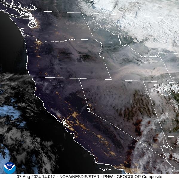
Source: NOAA
Forecast
A northwesterly flow will provide much cooler air for the region on Wednesday, particularly east of the Continental Divide. The cooler temperatures and higher humidity should help moderate fire behavior and limit smoke production. Showers are possible on Wednesday over Central Montana, but it will be nothing like the heavy rain and thunderstorms the region experienced the day prior.
There are still numerous large, active fires burning upstream in Idaho, Washington, and Oregon. Thanks to the northerly push of air, much of the smoke from these fires will stay out of the Treasure State. However, the northerly flow will bring some surface smoke into the state from wildfires burning in Canada. Much of this smoke will remain aloft so significant impacts due to smoke are unlikely.
Montana should remain under a zonal flow between Friday and early next week. This will keep things unsettled, with nearly daily chances of rain. The combination of seasonably cool air and the threat of rain should keep smoke production from regional wildfires in check. Stay tuned!
By Thursday night, the HRRR smoke model shows smoke from Canadian wildfires sagging south into Montana.
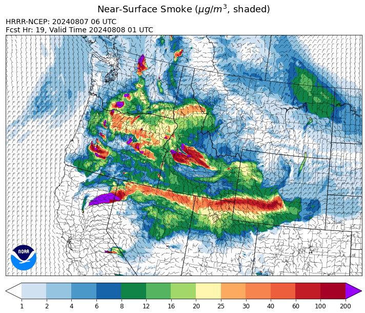
Source: HRRR Smoke
Conditions can change quickly as weather could stimulate active fires and the likelihood of new starts increases. Please keep track of concentrations at todaysair.mtdeq.us or the Fire and Smoke Map.
Current Wildfires
|
Incident |
State |
location |
acres |
containment |
|
Limepoint Fire - IDPAF |
Idaho |
8 miles NE of Oxbow Dam |
25,803 |
8% |
|
Cliff Mountain - IDPAF |
Idaho |
25 Miles East of Joseph, Oregon |
1,108 |
20% |
|
Wapiti Fire - IDBOF |
Idaho |
2 miles southwest of Grandjean, ID |
740 |
0% |
|
Bulltrout Fire - IDBOF |
Idaho |
15 miles WNW OF Stanley, ID |
271 |
65% |
|
Boulder Fire - IDBOF |
Idaho |
9 Miles southwest of Cascade, Idaho. |
1,023 |
6% |
|
Wolf Creek Fire - IDPAF |
Idaho |
5 miles west of Donnelly, ID |
1,149 |
14% |
|
Wye Fire - IDNCF |
Idaho |
Approximately four and a half miles northwest of Freeman Peak and seven miles northeast of the Moose Creek Airstrip |
3,760 |
NA |
|
Anchor Fire - IDNCF |
Idaho |
About half way between Hanover Mountain and Square Mountain in the Gospel Hump Wilderness |
72 |
NA |
|
Ace Butte Fire - IDNCF |
Idaho |
Approximately 30 miles Southeast of Grangeville, Idaho |
64 |
NA |
|
Shepp Fire - IDNCF |
Idaho |
Approximately 30 miles Southwest of Elk City, Idaho |
100 |
NA |
|
Bluff Creek Complex - IDIPF |
Idaho |
The fires are burning along both sides of the Bluff Ridge, approximately 13 1/2 miles southeast of Avery, ID; five and a half miles west from Gold Creek Campground; and approximately two miles northwest of Junction Ridge. |
432 |
NA |
|
2024 Gwen Fire - IDIDS |
Idaho |
South of Juliaetta Idaho, about 30 miles outside Lewiston near State Highway 3 in Latah County |
28,820 |
90% |
|
Bench Lake Fire - IDSTF |
Idaho |
8 miles south of Stanley, Idaho |
2,595 |
90% |
|
Oxbow Fire - IDPAF |
Idaho |
Near Oxbow dam in Hells Canyon |
6,000 |
NA |
|
Texas Fire - IDIDS |
Idaho |
Two miles East of Kendrick, ID |
1,582 |
90% |
|
Billy Creek Fire - IDIDS |
Idaho |
14.71 Miles SSE of Asotin, WA |
3,185 |
74% |
|
Thunder Fire - IDSCF |
Idaho |
12 miles south, southwest of Salmon, ID |
2,474 |
75% |
|
Grouse - MTBDF |
Montana |
Ten miles southwest of Wise River, MT |
3,500 |
NA |
|
Pentagon Fire - MTFNF |
Montana |
45 miles SE of Bigfork, MT |
62 |
0% |
|
Johnson Fire - MTBRF |
Montana |
3 miles west of the Springer Memorial Community in the East Fork |
270 |
0% |
|
Miller Peak Fire - MTLNF |
Montana |
7 miles southeast of Missoula |
2,724 |
75% |
|
Black Mountain - MTHLF |
Montana |
6 miles northwest of Lincoln. Mont. |
180 |
35% |
|
Muir Creek Fire - MTGNP |
Montana |
20 miles southeast of West Glacier, MT and east of the Middle Fork of the Flathead River |
30 |
0% |
|
Butler Creek Fire - MTMTS |
Montana |
5 miles northwest of Missoula |
284 |
100% |
|
Horse Gulch Fire - MTHLF |
Montana |
1/2 mile north of Canyon Ferry Dam near Helena, Montana |
15,167 |
100% |
|
Deadman Fire - MTMTS |
Montana |
Approx 17 mi south of Birney and north of the Tongue River Reservoir in Rosebud and Big Horn Counties |
47,827 |
NA |
|
Courtrock Fire - OR95S |
Oregon |
7.1 Miles south of Monument, OR |
20,019 |
77% |
|
Cottage Grove - Lane 1 - OR77S |
Oregon |
Approximately 16 miles SE of Springfield, OR |
15,830 |
9% |
|
Homestead Complex - ORUPF |
Oregon |
Thirty miles northeast of Glide Oregon |
2,851 |
14% |
|
Oakridge Lightning Fires 2024 - ORWIF |
Oregon |
Willamette Complex fires are to the north and south of Oakridge. |
11,734 |
0% |
|
Durkee Fire - ORVAD |
Oregon |
1 mile west of Durkee, Oregon |
294,265 |
95% |
|
Telephone Fire - ORMAF |
Oregon |
16 miles north east of Burns, Oregon |
53,388 |
31% |
|
Lone Rock Fire - ORPRD |
Oregon |
Lonerock stretching to west of HWY 207 and south to HWY 19 |
137,222 |
92% |
|
Diamond Complex - ORUPF |
Oregon |
18 miles southwest of Chemult, Oregon |
6,630 |
11% |
|
Ore Fire - ORWIF |
Oregon |
7 Miles NE of Blue River, OR |
2,001 |
29% |
|
Middle Fork Fire - ORCLP |
Oregon |
Middle Fork area, west of Crater Lake, Crater Lake National Park |
2,315 |
1% |
|
Microwave Tower Fire - OR95S |
Oregon |
1 mile WSW of Mosier, OR |
1,313 |
89% |
|
Whisky Creek Fire - ORMHF |
Oregon |
East fork of Herman Creek, 6 miles SE of Cascade Locks, OR |
1,330 |
0% |
|
Porcupine Fire - ORBUD |
Oregon |
Porcupine Reservoir |
5,000 |
25% |
|
Sandstone Fire - ORMHF |
Oregon |
NA |
350 |
0% |
|
Red Fire - ORDEF |
Oregon |
Diamond Peak Wilderness |
498 |
0% |
|
Falls Fire - ORMAF |
Oregon |
20 miles NW of Burns |
147,161 |
75% |
|
Crazy Creek - OROCF |
Oregon |
Crazy Creek:16 miles north of Paulina, OR |
71,625 |
19% |
|
Adam Mountain - ORUPF |
Oregon |
Approximately 6 miles southeast of Dorena, Oregon |
12,645 |
9% |
|
Badland Complex 2024 - ORVAD |
Oregon |
Baker County, Oregon |
54,563 |
99% |
|
Winding Waters Complex - OR97S |
Oregon |
23 miles east of Union, OR |
752 |
83% |
|
Cow Valley Fire - ORVAD |
Oregon |
West of Brogan and Northwest of Vale |
133,490 |
99% |
|
Salt Creek - OR710S |
Oregon |
5 miles SSW of Butte Falls, Oregon |
4,102 |
100% |
|
Larch Creek Fire - OR95S |
Oregon |
Friend, OR, a rural community |
18,286 |
81% |
|
Cougar Creek Fire - WASES |
Washington |
1 mile west of Hwy 129 and Grand Ronde river intersection |
20,699 |
35% |
|
Retreat - WASES |
Washington |
14 miles southwest of Naches, WA |
44,588 |
64% |
|
Pioneer - WASES |
Washington |
Approximate start 10 miles southeast of Stehekin, WA |
36,763 |
12% |
|
Swawilla Fire - WACOA |
Washington |
North of Columbia River, East of Swawilla Basin, West of Hwy 21 |
53,462 |
94% |
|
Bridge Creek - WACOA |
Washington |
North of Bridge Creek, East of Elbow River |
3,998 |
100% |
|
Pincer Two Fire - WAMSF |
Washington |
Johannesburg Mountain. 1 Mile East of Mineral Park C.G. |
115 |
0% |
|
Lower Granite Fire - WANES |
Washington |
Northeast of Pomeroy, WA |
14,482 |
100% |
|
Easy Fire - WAOWF |
Washington |
North Cascades Hwy 20 Corridor, 17 air miles west of Mazama, WA |
1,056 |
0% |
|
Black Canyon - WASES |
Washington |
10 Miles NW, Naches, WA |
9,211 |
99% |
|
South Columbia Basin - WANES |
Washington |
9.5 Miles WSW of Cheney, WA |
252 |
100% |
|
Big Horn Fire - WASES |
Washington |
7 miles SE of Bickleton Washington, and 7 miles N of Roosevelt, Washington |
51,569 |
100% |
Source: Inciweb
Tags: Smoke Forecast 2024