
Smoke Forecast for Tuesday, August 6, 2024
Current Conditions
Rain fell across much of the region on Monday, helping to moderate wildfire behavior. Through Monday, there have been 1,247 fires in Montana and a total of 105,371 acres burned.
The Grouse fire burning in the Pioneer Mountains 10 miles southwest of Wise River was the most active wildfire in the state for much of last week. It has burned 2,600 acres and is 0% contained.
At 8:00 AM Tuesday, Libby, Great Falls, Lewistown, and Billings were enduring Moderate air quality.
Tuesday morning’s satellite shows a heavy plume of smoke drifting into Montana from fires burning in Idaho, Oregon, and California.
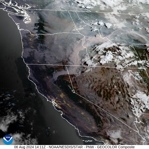
Source: NOAA
Forecast
The Grouse fire burning in the Pioneer Mountain remains the most active wildfire in Montana as of Tuesday morning. Rain fell on the fire, and across much of Western Montana on Monday, tempering fire behavior and limiting smoke production.
Another round of thunderstorms will develop Tuesday afternoon and evening. Some of these storms have the potential to produce large hail and damaging wind gusts. Precipitation from this system should linger into Wednesday morning.
A cool front on Wednesday will bring another round of showers and storms in the afternoon. However, these aren’t expected to be as widespread or intense as the Tuesday version. The front will usher in seasonably cool air, especially east of the Continental Divide. Behind the front, a northerly flow will send smoke from Canadian wildfires into Montana. The greatest impact from this smoke will be generally north of I-90. Stay tuned!
By Wednesday night, the HRRR smoke model shows smoke from Canadian wildfires sagging south into Montana.
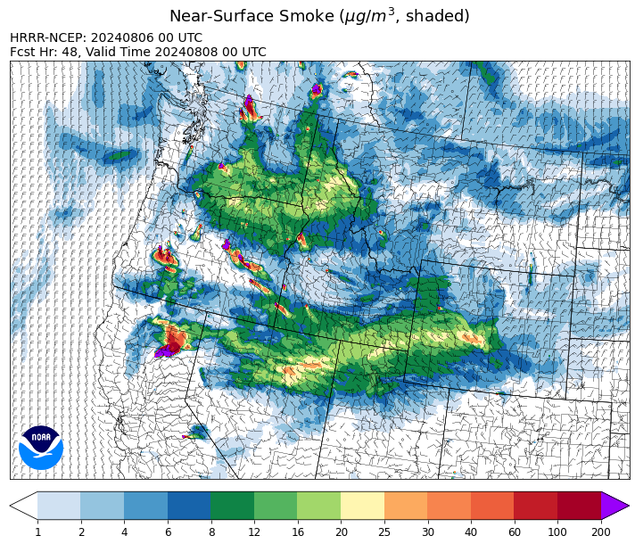
Source: HRRR Smoke
Conditions can change quickly as weather could stimulate active fires and the likelihood of new starts increases. Please keep track of concentrations at todaysair.mtdeq.us or the Fire and Smoke Map.
Current Wildfires
|
Incident |
State |
location |
acres |
containment |
|
Bulltrout Fire - IDBOF |
Idaho |
15 miles W-NW OF Stanley, ID |
271 |
55% |
|
Wapiti Fire - IDBOF |
Idaho |
2 miles southwest of Grandjean, ID |
205 |
0% |
|
Limepoint Fire - IDPAF |
Idaho |
8 miles NE of Oxbow Dam |
25,295 |
8% |
|
Cliff Mountain - IDPAF |
Idaho |
25 Miles East of Joseph, Oregon |
1,108 |
20% |
|
Wolf Creek Fire - IDPAF |
Idaho |
5 miles west of Donnelly, ID |
1,138 |
4% |
|
Boulder Fire - IDBOF |
Idaho |
9 Miles southwest of Cascade, Idaho. |
841 |
5% |
|
Bluff Creek Complex - IDIPF |
Idaho |
The fires are burning along both sides of the Bluff Ridge, approximately 13 1/2 miles southeast of Avery, ID; five and a half miles west from Gold Creek Campground; and approximately two miles northwest of Junction Ridge. |
432 |
NA |
|
2024 Gwen Fire - IDIDS |
Idaho |
South of Juliaetta Idaho, about 30 miles outside Lewiston near State Highway 3 in Latah County |
28,820 |
90% |
|
Ace Butte - IDNCF |
Idaho |
Approximately 30 miles Southeast of Grangeville, Idaho |
64 |
NA |
|
Anchor - IDNCF |
Idaho |
About half way between Hanover Mountain and Square Mountain in the Gospel Hump Wilderness |
72 |
NA |
|
Bench Lake Fire - IDSTF |
Idaho |
8 miles south of Stanley, Idaho |
2,595 |
90% |
|
Shepp - IDNCF |
Idaho |
Approximately 30 miles Southwest of Elk City, Idaho |
100 |
NA |
|
Wye Fire - IDNCF |
Idaho |
Approximately four and a half miles northwest of Freeman Peak and seven miles northeast of the Moose Creek Airstrip |
3,500 |
NA |
|
Oxbow Fire - IDPAF |
Idaho |
Near Oxbow dam in Hells Canyon |
6,000 |
NA |
|
Thunder Fire - IDSCF |
Idaho |
12 miles south, southwest of Salmon, ID |
2,474 |
50% |
|
Johnson Fire - MTBRF |
Montana |
3 miles west of the Springer Memorial Community in the East Fork |
305 |
0% |
|
Pentagon Fire - MTFNF |
Montana |
45 miles SE of Bigfork, MT |
62 |
0% |
|
Black Mountain - MTHLF |
Montana |
6 miles northwest of Lincoln. Mont. |
180 |
30% |
|
Miller Peak Fire - MTLNF |
Montana |
7 miles southeast of Missoula |
2,724 |
73% |
|
Muir Creek Fire - MTGNP |
Montana |
20 miles southeast of West Glacier, MT and east of the Middle Fork of the Flathead River |
30 |
0% |
|
Courtrock Fire - OR95S |
Oregon |
7.1 Miles south of Monument, OR |
20,018 |
57% |
|
Lone Rock Fire - ORPRD |
Oregon |
Lonerock stretching to west of HWY 207 and south to HWY 19 |
137,222 |
92% |
|
Diamond Complex - ORUPF |
Oregon |
18 miles southwest of Chemult, Oregon |
6,630 |
11% |
|
Falls Fire - ORMAF |
Oregon |
20 miles NW of Burns |
147,161 |
75% |
|
Homestead Complex - ORUPF |
Oregon |
Thirty miles northeast of Glide Oregon |
2,670 |
10% |
|
Durkee Fire - ORVAD |
Oregon |
1 mile west of Durkee, Oregon |
294,265 |
90% |
|
Oakridge Lightning Fires 2024 - ORWIF |
Oregon |
Willamette Complex fires are to the north and south of Oakridge. |
11,415 |
0% |
|
Ore Fire - ORWIF |
Oregon |
7 Miles NE of Blue River, OR |
1,874 |
29% |
|
Battle Mountain Complex - OR97S |
Oregon |
West and south of Ukiah, OR |
181,941 |
39% |
|
Microwave Tower Fire - OR95S |
Oregon |
1 mile WSW of Mosier, OR |
1,313 |
89% |
|
Middle Fork Fire - ORCLP |
Oregon |
Middle Fork area, west of Crater Lake, Crater Lake National Park |
1,980 |
1% |
|
Cottage Grove - Lane 1 - OR77S |
Oregon |
Approximately 16 miles SE of Springfield, OR |
2,456 |
9% |
|
Whisky Creek Fire - ORMHF |
Oregon |
East fork of Herman Creek, 6 miles SE of Cascade Locks, OR |
1,330 |
0% |
|
Adam Mountain - ORUPF |
Oregon |
Approximately 6 miles southeast of Dorena, Oregon |
12,645 |
9% |
|
Badland Complex 2024 - ORVAD |
Oregon |
Baker County, Oregon |
54,563 |
99% |
|
Telephone Fire - ORMAF |
Oregon |
16 miles north east of Burns, Oregon |
52,130 |
31% |
|
Red Fire - ORDEF |
Oregon |
Diamond Peak Wilderness |
490 |
0% |
|
Winding Waters Complex - OR97S |
Oregon |
23 miles east of Union, OR |
752 |
83% |
|
Crazy Creek - OROCF |
Oregon |
Crazy Creek:16 miles north of Paulina, OR |
64,288 |
6% |
|
Cow Valley Fire - ORVAD |
Oregon |
West of Brogan and Northwest of Vale |
133,490 |
99% |
|
Retreat - WASES |
Washington |
14 miles southwest of Naches, WA |
44,540 |
53% |
|
Pioneer - WASES |
Washington |
Approximate start 10 miles southeast of Stehekin, WA |
36,763 |
12% |
|
Lower Granite Fire - WANES |
Washington |
Northeast of Pomeroy, WA |
14,482 |
100% |
|
Swawilla Fire - WACOA |
Washington |
North of Columbia River, East of Swawilla Basin, West of Hwy 21 |
53,462 |
90% |
|
Bridge Creek - WACOA |
Washington |
North of Bridge Creek, East of Elbow River |
3,998 |
100% |
|
Easy Fire - WAOWF |
Washington |
North Cascades Hwy 20 Corridor, 17 air miles west of Mazama, WA |
1,056 |
0% |
|
Cougar Creek Fire - WASES |
Washington |
1 mile west of Hwy 129 and Grand Ronde river intersection |
20,712 |
35% |
|
Pincer Two Fire - WAMSF |
Washington |
Johanasburg Mountain. 1 Mile East of Mineral Park C.G. |
110 |
0% |
|
Black Canyon - WASES |
Washington |
10 Miles NW, Naches, WA |
9,211 |
99% |
|
South Columbia Basin - WANES |
Washington |
9.5 Miles WSW of Cheney, WA |
252 |
100% |
|
Big Horn Fire - WASES |
Washington |
7 miles SE of Bickleton Washington, and 7 miles N of Roosevelt, Washington |
51,569 |
100% |
Source: Inciweb
Tags: Smoke Forecast 2024