
Smoke Forecast for Monday, August 5, 2024
Current Conditions
Cooler temperatures and rain over the weekend helped to temper fire behavior and smoke production on existing wildfires in the region. Up to an inch of rain fell on Sunday in the higher terrain of Western Montana, where several active fires continue to burn.
The Grouse fire burning in the Pioneer Mountains was the most active wildfire in the state for much of last week. It has burned 2,600 acres and is 0% contained.
At 8:00 AM Monday, Libby, Thompson Falls, Columbia Falls, Choteau, Bozeman Great Falls, Hamilton, Cut Bank, Havre, Lewistown, and Broadus were enduring Moderate air quality.
Monday morning’s satellite shows a disturbance moving across the Northern Rockies and Pacific Northwest. Widespread fog can be seen over the northern half of the state, where heavy rain fell over the weekend.
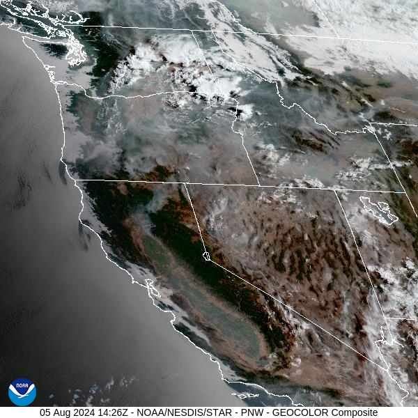
Source: NOAA
Forecast
Surface smoke isn’t nearly as widespread across the state as it was a week ago. However, there is still quite a bit of smoke upstream in Idaho, Washington, and Oregon. High pressure builds over the Northern Rockies on Monday. It will provide unseasonably warm temperatures for the area. Scattered thunderstorms are possible in the afternoon and evening, but widespread rain is unlikely.
Tuesday is likely the best opportunity for rain this week. There’s even a slight risk of severe storms, with heavy rain, gusty winds, and even some hail possible. Isolated dry thunderstorms are possible over Southwest Montana on Tuesday, which could result in new wildfires down the road.
A trough of low pressure will slide south out of British Columbia by Tuesday night and Wednesday. It will bring much cooler air into the Northern Rockies and provide additional chances for rain. The trough will also bring down surface smoke into Western Montana from fires burning in Western Canada. This smoke could bring deteriorating air quality levels, particularly to Northwest Montana. Stay tuned!
By Tuesday night, the HRRR smoke model shows increasing surface smoke over Northwest Montana from fires burning in Western Canada.
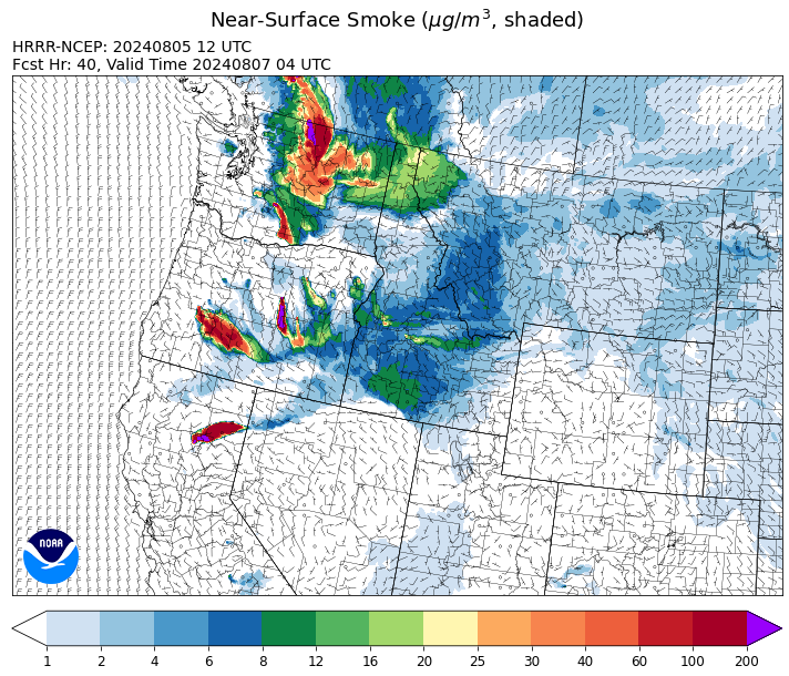
Source: HRRR Smoke
Conditions can change quickly as weather could stimulate active fires and the likelihood of new starts increases. Please keep track of concentrations at todaysair.mtdeq.us or the Fire and Smoke Map.
Currrent Wildfires
|
Incident |
State |
location |
acres |
containment |
|
Wolf Creek Fire - IDPAF |
Idaho |
5 miles west of Donnelly, ID |
1,137 |
4% |
|
Boulder Fire - IDBOF |
Idaho |
9 Miles southwest of Cascade, Idaho. |
926 |
5% |
|
Bulltrout Fire - IDBOF |
Idaho |
15 miles W-NW OF Stanley, ID |
292 |
41% |
|
Wapiti Fire - IDBOF |
Idaho |
2 miles southwest of Grandjean, ID |
205 |
0% |
|
Limepoint Fire - IDPAF |
Idaho |
8 miles NE of Oxbow Dam |
24,605 |
5% |
|
Cliff Mountain - IDPAF |
Idaho |
25 Miles East of Joseph, Oregon |
1,108 |
20% |
|
Bluff Creek Complex - IDIPF |
Idaho |
The fires are burning along both sides of the Bluff Ridge, approximately 13 1/2 miles southeast of Avery, ID; five and a half miles west from Gold Creek Campground; and approximately two miles northwest of Junction Ridge. |
432 |
NA |
|
2024 Gwen Fire - IDIDS |
Idaho |
South of Juliaetta Idaho, about 30 miles outside Lewiston near State Highway 3 in Latah County |
28,820 |
90% |
|
Ace Butte - IDNCF |
Idaho |
Approximately 30 miles Southeast of Grangeville, Idaho |
64 |
NA |
|
Anchor - IDNCF |
Idaho |
About half way between Hanover Mountain and Square Mountain in the Gospel Hump Wilderness |
72 |
NA |
|
Bench Lake Fire - IDSTF |
Idaho |
8 miles south of Stanley, Idaho |
2,595 |
90% |
|
Shepp - IDNCF |
Idaho |
Approximately 30 miles Southwest of Elk City, Idaho |
100 |
NA |
|
Wye Fire - IDNCF |
Idaho |
Approximately four and a half miles northwest of Freeman Peak and seven miles northeast of the Moose Creek Airstrip |
3,500 |
NA |
|
Oxbow Fire - IDPAF |
Idaho |
Near Oxbow dam in Hells Canyon |
6,000 |
NA |
|
Thunder Fire - IDSCF |
Idaho |
12 miles south, southwest of Salmon, ID |
2,474 |
50% |
|
Miller Peak Fire - MTLNF |
Montana |
7 miles southeast of Missoula |
2,724 |
73% |
|
Black Mountain - MTHLF |
Montana |
6 miles northwest of Lincoln. Mont. |
180 |
0% |
|
Johnson Fire - MTBRF |
Montana |
3 miles west of the Springer Memorial Community in the East Fork |
305 |
0% |
|
Muir Creek Fire - MTGNP |
Montana |
20 miles southeast of West Glacier, MT and east of the Middle Fork of the Flathead River |
30 |
0% |
|
Cottage Grove - Lane 1 - OR77S |
Oregon |
Approximately 16 miles SE of Springfield, OR |
2,395 |
9% |
|
Badland Complex 2024 - ORVAD |
Oregon |
Baker County, Oregon |
54,563 |
99% |
|
Telephone Fire - ORMAF |
Oregon |
16 miles north east of Burns, Oregon |
52,130 |
31% |
|
Whisky Creek Fire - ORMHF |
Oregon |
East fork of Herman Creek, 6 miles SE of Cascade Locks, OR |
1,174 |
0% |
|
Durkee Fire - ORVAD |
Oregon |
1 mile west of Durkee, Oregon |
294,690 |
86% |
|
Winding Waters Complex - OR97S |
Oregon |
23 miles east of Union, OR |
752 |
83% |
|
Homestead Complex - ORUPF |
Oregon |
Thirty miles northeast of Glide Oregon |
2,532 |
9% |
|
Battle Mountain Complex - OR97S |
Oregon |
West and south of Ukiah, OR |
181,941 |
36% |
|
Lone Rock Fire - ORPRD |
Oregon |
Lonerock stretching to west of HWY 207 and south to HWY 19 |
137,222 |
92% |
|
Courtrock Fire - OR95S |
Oregon |
7.1 Miles south of Monument, OR |
20,018 |
57% |
|
Adam Mountain - ORUPF |
Oregon |
Approximately 6 miles southeast of Dorena, Oregon |
11,998 |
9% |
|
Oakridge Lightning Fires 2024 - ORWIF |
Oregon |
Willamette Complex fires are to the north and south of Oakridge. |
10,450 |
0% |
|
Diamond Complex - ORUPF |
Oregon |
18 miles southwest of Chemult, Oregon |
6,133 |
11% |
|
Ore Fire - ORWIF |
Oregon |
7 Miles NE of Blue River, OR |
1,766 |
29% |
|
Middle Fork Fire - ORCLP |
Oregon |
Middle Fork area, west of Crater Lake, Crater Lake National Park |
1,938 |
1% |
|
Red Fire - ORDEF |
Oregon |
Diamond Peak Wilderness |
490 |
0% |
|
Microwave Tower Fire - OR95S |
Oregon |
5 miles WSW of Mosier, OR |
1,311 |
84% |
|
Falls Fire - ORMAF |
Oregon |
20 miles NW of Burns |
146,000 |
73% |
|
Crazy Creek - OROCF |
Oregon |
Crazy Creek:16 miles north of Paulina, OR |
60,091 |
5% |
|
Cow Valley Fire - ORVAD |
Oregon |
West of Brogan and Northwest of Vale |
133,490 |
99% |
|
Retreat - WASES |
Washington |
14 miles southwest of Naches, WA |
41,279 |
49% |
|
Pioneer - WASES |
Washington |
Approximate start 10 miles southeast of Stehekin, WA |
35,607 |
12% |
|
Cougar Creek Fire - WASES |
Washington |
1 mile west of Hwy 129 and Grand Ronde river intersection |
20,666 |
35% |
|
Swawilla Fire - WACOA |
Washington |
North of Columbia River, East of Swawilla Basin, West of Hwy 21 |
53,403 |
90% |
|
Bridge Creek - WACOA |
Washington |
North of Bridge Creek, East of Elbow River |
3,998 |
100% |
|
Pincer Two Fire - WAMSF |
Washington |
Johanasburg Mountain. 1 Mile East of Mineral Park C.G. |
102 |
0% |
|
Easy Fire - WAOWF |
Washington |
North Cascades Hwy 20 Corridor, 17 air miles west of Mazama, WA |
528 |
0% |
|
Lower Granite Fire - WANES |
Washington |
Northeast of Pomeroy, WA |
14,482 |
99% |
|
Black Canyon - WASES |
Washington |
10 Miles NW, Naches, WA |
9,211 |
99% |
|
South Columbia Basin - WANES |
Washington |
9.5 Miles WSW of Cheney, WA |
252 |
100% |
|
Big Horn Fire - WASES |
Washington |
7 miles SE of Bickleton Washington, and 7 miles N of Roosevelt, Washington |
51,569 |
100% |
Source: Inciweb
Tags: Smoke Forecast 2024