
Smoke Forecast for Friday, August 2, 2024 9:00 AM
Current Conditions
A ridge of high pressure will peak on Friday over the Northern Rockies and Montana, producing the hottest day of the week. After a slow start, fire behavior has begun to perk up on several regional wildfires.
The Grouse fire burning in the Pioneer Mountains grew significantly on Thursday and was the most active fire on satellite. It has grown to 800 acres with 0% of the fire contained. Numerous regional wildfires in Washington and Oregon grew on Thursday, and the smoke from these blazes is pouring into parts of Montana.
At 8:00 AM Friday, Frenchtown, Great Falls, Lewistown, Billings, Broadus, and Sidney were enduring Moderate air quality.
Friday morning’s satellite shows smoke trickling into Montana from fires burning upstream in Washington, Oregon, and Idaho. Monsoonal moisture is providing plenty of clouds over the Desert Southwest.
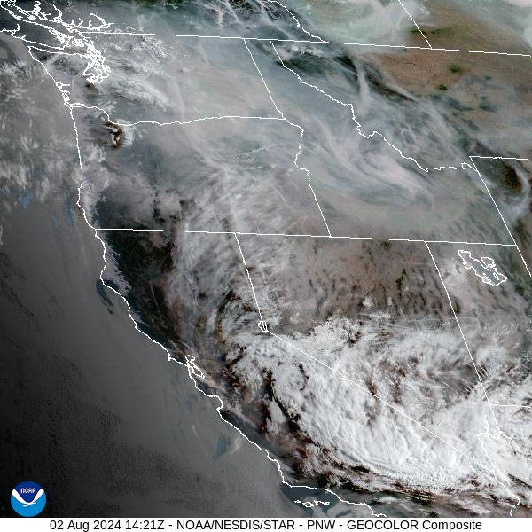
Source: NOAA
Forecast
Smoke will gradually increase over the Northern Rockies through Saturday as heat builds under a ridge of high pressure. Skies will be noticeably smokier after the break we enjoyed Wednesday and Thursday. Many of the valleys in Western Montana will break the century make Friday and Saturday. The combination of excessive heat, low humidity, and gusty afternoon winds will lead to erratic fire behavior on existing wildfires and deteriorating air quality.
Monsoonal moisture will arrive by late Saturday and Sunday. It will provide increasing clouds for the region, with chances for rain and thunderstorms. The shift in winds will provide chances for some beneficial rainfall. Much of the state, particularly west of the Continental Divide, is enduring a worsening drought. The thunderstorms will also bring the potential for lightning and the threat for new wildfires.
The moisture from the Desert Southwest will continue to stream north into Montana for much of the upcoming week. It should keep daily chances for rain and thunderstorms in the forecast. A cold front will move across the region by midweek. The combination of cooler temperatures, clouds, and precipitation should help ease fire behavior and smoke production for much of the state.
By Saturday afternoon, the HRRR smoke model shows increasing surface smoke over Western Montana from regional wildfires.
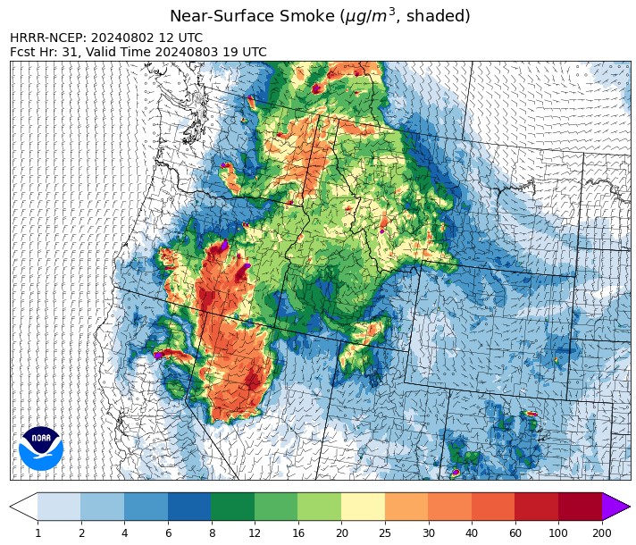
Source: HRRR Smoke
Conditions can change quickly as weather could stimulate active fires and the likelihood of new starts increases. Please keep track of concentrations at todaysair.mtdeq.us or the Fire and Smoke Map.
Current Wildfires
|
Incident |
State |
location |
acres |
containment |
|
Wapiti Fire - IDBOF |
Idaho |
2 miles southwest of Grandjean |
86 |
0% |
|
Bulltrout Fire - IDBOF |
Idaho |
15 MILE WNW OF STANLEY, ID |
292 |
15% |
|
Boulder Fire - IDBOF |
Idaho |
9 Miles southwest of Cascade, Idaho. |
620 |
7% |
|
Cliff Mountain - IDPAF |
Idaho |
25 Miles East of Joseph, Oregon |
1,107 |
0% |
|
Limepoint Fire - IDPAF |
Idaho |
8 miles NE of Oxbow Dam |
18,734 |
0% |
|
Wolf Creek Fire - IDPAF |
Idaho |
5 miles west of Donnelly, ID |
909 |
2% |
|
2024 Gwen Fire - IDIDS |
Idaho |
South of Juliaetta Idaho, about 30 miles outside Lewiston near State Highway 3 in Latah County |
28,410 |
85% |
|
Shepp - IDNCF |
Idaho |
Approximately 30 miles Southwest of Elk City, Idaho |
100 |
NA |
|
Ace Butte - IDNCF |
Idaho |
Approximately 30 miles Southeast of Grangeville, Idaho |
75 |
NA |
|
Anchor - IDNCF |
Idaho |
About half way between Hanover Mountain and Square Mountain in the Gospel Hump Wilderness |
50 |
NA |
|
Wye Fire - IDNCF |
Idaho |
Approximately four and a half miles northwest of Freeman Peak and seven miles northeast of the Moose Creek Airstrip |
3,500 |
NA |
|
Bluff Creek Complex - IDIPF |
Idaho |
The fires are burning along both sides of the Bluff Ridge, approximately 13 1/2 miles southeast of Avery, ID; five and a half miles west from Gold Creek Campground; and approximately two miles northwest of Junction Ridge. |
432 |
NA |
|
Bench Lake Fire - IDSTF |
Idaho |
8 miles south of Stanley, Idaho |
2,595 |
85% |
|
Oxbow Fire - IDPAF |
Idaho |
Near Oxbow dam in Hells Canyon |
6,000 |
NA |
|
Thunder Fire - IDSCF |
Idaho |
12 miles south, southwest of Salmon, ID |
2,474 |
34% |
|
Black Mountain - MTHLF |
Montana |
6 miles northwest of Lincoln. Mont. |
76 |
0% |
|
Miller Peak Fire - MTLNF |
Montana |
7 miles southeast of Missoula |
2,724 |
65% |
|
Muir Creek Fire - MTGNP |
Montana |
20 miles southeast of West Glacier, MT and east of the Middle Fork of the Flathead River |
30 |
0% |
|
Blacktail Canyon - MTBDF |
Montana |
4 miles southeast of Butte, MT |
80 |
95% |
|
Butler Creek Fire - MTMTS |
Montana |
5 miles northwest of Missoula |
284 |
100% |
|
Horse Gulch Fire - MTHLF |
Montana |
1/2 mile north of Canyon Ferry Dam near Helena, Montana |
15,167 |
100% |
|
Durkee Fire - ORVAD |
Oregon |
1 mile west of Durkee, Oregon |
293,882 |
63% |
|
Winding Waters Complex - OR97S |
Oregon |
23 miles east of Union, OR |
752 |
29% |
|
Microwave Tower Fire - OR95S |
Oregon |
5 miles WSW of Mosier, OR |
1,311 |
84% |
|
Lone Rock Fire - ORPRD |
Oregon |
Lonerock OR stretching to west of HWY 207 and south to HWY 19 |
137,222 |
83% |
|
Homestead Complex - ORUPF |
Oregon |
Thirty miles northeast of Glide Oregon |
2,043 |
5% |
|
Whisky Creek Fire - ORMHF |
Oregon |
East fork of Herman Creek, 6 miles SE of Cascade Locks, OR |
891 |
0% |
|
Battle Mountain Complex - OR97S |
Oregon |
West and south of Ukiah, OR |
179,080 |
23% |
|
Adam Mountain - ORUPF |
Oregon |
Approximately 6 miles southeast of Dorena, Oregon |
10,413 |
7% |
|
Middle Fork Fire - ORCLP |
Oregon |
Middle Fork area, west of Crater Lake, Crater Lake National Park |
728 |
1% |
|
Diamond Complex - ORUPF |
Oregon |
18 miles southwest of Chemult, Oregon |
5,622 |
11% |
|
Badland Complex 2024 - ORVAD |
Oregon |
Baker County, Oregon |
54,563 |
75% |
|
Courtrock Fire - OR95S |
Oregon |
7.1 Miles S. of Monument, Oregon |
19,282 |
41% |
|
Ore Fire - ORWIF |
Oregon |
7 Miles NE of Blue River, OR |
1,539 |
29% |
|
Red Fire - ORDEF |
Oregon |
Diamond Peak Wilderness |
428 |
0% |
|
Telephone Fire - ORMAF |
Oregon |
16 miles north east of Burns, Oregon |
38,726 |
23% |
|
Falls Fire - ORMAF |
Oregon |
20 miles NW of Burns |
143,236 |
73% |
|
Crazy Creek - OROCF |
Oregon |
Crazy Creek:16 miles north of Paulina, OR |
31,440 |
5% |
|
Cow Valley Fire - ORVAD |
Oregon |
West of Brogan and Northwest of Vale |
133,490 |
99% |
|
Easy Fire - WAOWF |
Washington |
North Cascades Hwy 20 Corridor, 17 air miles west of Mazama, WA |
528 |
0% |
|
Pioneer - WASES |
Washington |
Approximate start 10 miles southeast of Stehekin, WA |
33,761 |
12% |
|
Retreat - WASES |
Washington |
14 miles southwest of Naches, WA |
34,759 |
37% |
|
Pincer Two Fire - WAMSF |
Washington |
Johanasburg Mountain. 1 Mile East of Mineral Park C.G. |
102 |
0% |
|
Cougar Creek Fire - WASES |
Washington |
1 mile west of Hwy 129 and Grand Ronde river intersection |
18,258 |
29% |
|
Bridge Creek - WACOA |
Washington |
North of Bridge Creek, East of Elbow River |
3,950 |
55% |
|
Lower Granite Fire - WANES |
Washington |
Northeast of Pomeroy, WA |
14,482 |
50% |
|
Swawilla Fire - WACOA |
Washington |
North of Columbia River, East of Swawilla Basin, West of Hwy 21 |
50,012 |
65% |
|
Black Canyon - WASES |
Washington |
10 Miles NW, Naches, WA |
9,211 |
99% |
|
South Columbia Basin - WANES |
Washington |
9.5 Miles WSW of Cheney, WA |
252 |
100% |
|
Big Horn Fire - WASES |
Washington |
7 miles SE of Bickleton Washington, and 7 miles N of Roosevelt, Washington |
51,569 |
100% |
Source: Inciweb
Tags: Smoke Forecast 2024